18 - 19 FEBRUARY 1996 - DIAGNOSIS FOR 18 FEBRUARY 1996/06.00 UTC
by ZAMG
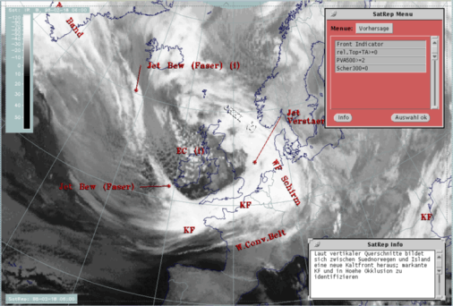
| Front Indicator | This is a line indicating the maximum of the thermal front parameter (TFP) 500/850 hPa (*10-1Km-1) |
|---|---|
| rel.Top + TA>=0 | This is a combination of the equivalent thickness 500/850 hPa (rel.Top) and warm advection (TA>=0) 500/1000 hPa; this combination of key parameters is especially indicative of the thermal qualities of an Occlusion |
| PVA500>=2 | This parameter shows maxima of positive vorticity advection (PVA) at 500 hPa exceeding 2 units (*10-9sec-2); this key parameter indicates areas with increased possibility for more severe weather events because of increased vertical motion (compare Front Intensification by Jet Crossing ) |
| Scher300=0 | The zero line of shear vorticity (Scher300=0) is a key parameter indicative of the relation between front and jet stream; in this connection the basic rule that the jet stream crosses the cloud band with its axis close to the Occlusion point is included. |
|
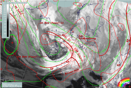
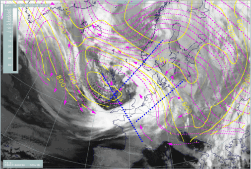
18 February 1996/06.00 UTC - Meteosat IR image; red thick: front indicator, green: equivalent thickness 500/850 hPa, red: temperature advection - WA
1000 hPa, SatRep overlay: names of conceptual models
|
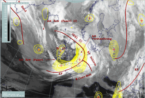
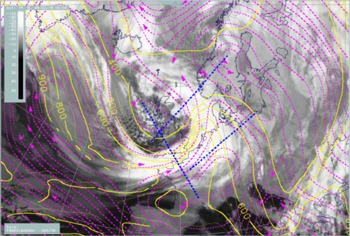
18 February 1996/06.00 UTC - Meteosat IR image; red thick: front indicator, yellow: positive vorticity advection (PVA) 500 hPa, SatRep overlay: names
of conceptual models
|
|
|
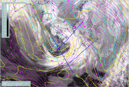
There is another very typical configuration fulfilled in the key parameters: the zero line of shear vorticity at 300 hPa representing the jet axis (black line) crosses the cloud band exactly at the Occlusion point indicated by the front indicator (thick red line).
As can be seen in the second image, this point as well as the southern part of the Occlusion band are under the influence of PVA.
Looking at these typical diagnoses there should be no doubt about the physical state of an Occlusion in the region under discussion. However, there are some indications that contradict this classical model. The cloud spiral in the satellite image is not as distinct as is usually the case with Occlusion bands, and there are some dissolution effects in the northern part over the North Sea. But the main difference appears in the vertical cross section.
|
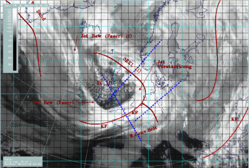
18 February 1996/06.00 UTC - Meteosat IR image; SatRep overlay: names of conceptual models, position of vertical cross section indicated
|
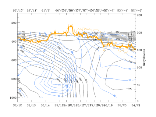
18 February 1996/06.00 UTC - Vertical cross section; black: isentropes (ThetaE), blue: relative humidity, orange thin: IR pixel values,
orange thick: WV pixel values
|
|
|
|
|
|
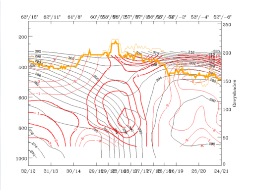
18 February 1996/06.00 UTC - Vertical cross section; black: isentropes (ThetaE), red thin: temperature advection - CA, red thick: temperature
advection - WA, orange thin: IR pixel values, orange thick: WV pixel values
|
In this case equivalent potential temperature shows a completely different structure. The main feature is a pronounced thick zone typical for a Cold Front, inclined from about 400 hPa over Sweden down to gridpoint 27/17, which is close to the rear end of the cloud band immediately east of the Scottish coast. A trough-like configuration in the isentropes only exists higher than approximately 600 hPa, and may indicate an Occlusion there.
Wet air is in front and on top of the frontal zone with very high values in high levels above 600 hPa; there is very dry air (less than 30%) within and below the frontal zone and an even drier maximum of less than 20% just approaching on top of the frontal zone from north-east. WV and IR pixel values are very similar with a jump from typically cloud-free to cloudy values near 61°N/08°E, and a rather broad band extends south-westwards over the trough feature in the isentropes. The vertical distribution of temperature advection shows the typical appearance of an Occlusion band with a maximum of WA centred around the trough in the isentropes, typical for an Occlusion but with maximal values of WA below it. The whole frontal zone north-eastward from the gridpoint 29/15 is under CA, an area which is already outside the main part of the cloud band.
Summarizing these different features, one can conclude on the basis of a couple of key parameters, that an Occlusion cloud band exists but is undergoing transformation to a new Cold Front. This process will be evaluated in more detail.
Two characteristic isentropic surfaces are selected: ThetaE = 290K, a surface which is within the frontal zone of the Cold Front close to its top and appears only in this cloud system, and ThetaE = 300K. This surface is relatively high in relation to this cloud system, but the connection to the main Warm and Cold Front cloud bands is more evident.
|
18 February 1996/06.00 UTC - Meteosat IR image; red thick: front indicator, magenta: relative streams 290K - system velocity 305° 18m/s, yellow:
isobars, SatRep overlay: names of conceptual models, position of vertical cross section indicated
|
18 February 1996/06.00 UTC - Meteosat IR image; red thick: front indicator, magenta: relative streams 300K - system velocity 305° 18m/s, yellow:
isobars, SatRep overlay: names of conceptual models, position of vertical cross section indicated
|
|
|
Another relative stream merges with the Cold Conveyor Belt from more north-eastern directions exactly in the region of the cross section. This stream is sinking from about 500 hPa down to 650 hPa where it meets the relative stream from the south which has been discussed above. Comparing again with the vertical cross section, this relative stream from east and north-east transports much drier air.
The higher 300K isentropic surface describes a layer between 400 and 350 hPa in the area of the vertical cross section. In this layer a relative stream from the humid side on the back of the Cold Front crosses (compare Cold Front and Conceptual Models: Cold Front - Meteorological physical background ) the vertical cross section, rising strongly over the North Sea but only moderately in the more northern part of the Occlusion. Describing the qualities of air masses at this height of the vertical cross section clearly shows that this is the region of highest humidity, connected with the brightest peak in the IR and WV imagery. So this relative stream is responsible for the formation of the high level cloudiness.
Similarly to the lower 290K surface, a sinking relative stream from north-eastern directions forms a limiting stream line for the north-eastern edge of the cloud band.
This may be a typical situation for the start of a transformation from Occlusion to Cold Front cloud band. For a further development see Forecast for "Special Investigation": 18 February 12.00 to 19 February 06.00 UTC .


