Cold Front - Meteorological Physical Background
by ZAMG and FMI
Cold Fronts can be devided into two types: Ana and Kata Cold Fronts. These types can be described both in terms of classical frontal theory and in terms of conveyor belts.
The main feature which separates the different types of Cold Front is the orientation of the jet relative to the front in the middle and upper levels of the troposphere:
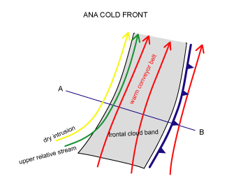
- In the case of an Ana Cold Front, the jet axis and dry intrusion are parallel to the frontal cloud band, and form a well pronounced rear cloud edge.
- In the case of a Kata cold front, the jet axis crosses the frontal cloud band.
Discussion
In the literature, as well in the studies carried out by ZAMG and FMI, there are some uncertainties about the structure of Ana and Kata types:- It is not always completely clear whether a Cold Front is Ana or Kata type.
- Even within the same front Ana and Kata structures can be observed; in these cases Ana features can be found close to the occlusion point, whereas Kata structures prevail in the parts of the front farther away.
- The frontal cloudiness, especially in Kata Cold Front, is often not produced solely by the Warm Conveyor Belt. The rear parts of the cloud band are produced by an upper relative stream orginating from the trough behind the Cold Front. This moist rising stream can sometimes be followed backwards as far as the area of Warm Front clouds. Thus, the upper relative stream is added to the schematics describing the conveyor belt model of the Ana and Kata Fronts.
- There can be parallel or even forward inclined Warm Conveyor Belts. The rearward component at lower levels is due to the ageostrophic wind within the boundary layer, while the parallel or even forward sloping Warm Conveyor Belt in the middle and upper levels is in accordance with the geostrophic wind relationship.
Ana Cold Front
According to the classical theory:- The cold air moves rapidly against warm air, creating convergence within the baroclinic zone between the two air masses.
- Convergence forces the warm, moist air to ascend along the frontal surface. The developing cloud band is inclined rearward with height.
- The main zone of cloudiness and precipitation is located behind the surface front.
- An exception is a case with strong upper winds which force the high clouds to extend downstream ahead of the surface front.
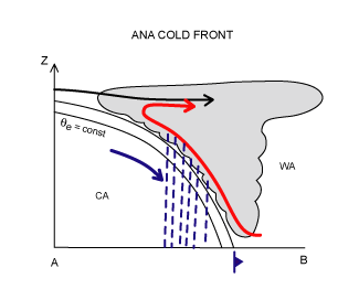
- The frontal cloud band and precipitation are related to an ascending Warm Conveyor Belt, which has a rearward component relative to the movement of the front, causing the frontal cloud band and precipitation to appear behind the surface front.
- Parallel to the warm conveyor belt there is a dry stream (dry intrusion). The sharp rear cloud edge of frontal cloudiness marks the transition between the two relative streams.
|
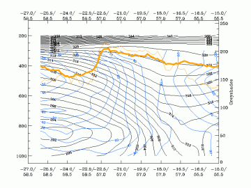
04 October 2005/12.00 UTC - Vertical cross section; black: isentropes, blue: relative humidity, orange thin: IR
pixel values, orange thick: WV pixel values
|
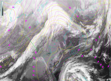
04 October 2005/12.00 UTC - Meteosat 8 IR 10.8 image; magenta: relative streams 308K - system velocity 236°
15 m/s, yellow: isobars 308K; position of vertical cross section indicated
|
|
|
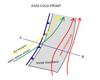
Kata Cold Front
According to classical theory:- The ascent of warm air is restricted by dry descending air originating from behind the front and, consequently, dissipating the higher clouds.
- The main zones of cloudiness and precipitation appear in front of the surface front.
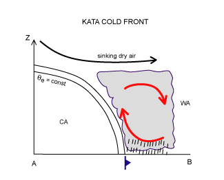
- The ascending Warm Conveyor Belt is overrun by the dry intrusion.
- The dry air originates from upper levels of the troposphere or even from the lower levels of the stratosphere, and crosses the Cold Front from behind.
- The warm conveyor belt acquires a component which is inclined forwards relative to the movement of the Cold Front. Therefore, frontal clouds and precipitation tend to lie ahead of the surface front.
- The cloud tops in the area of the dry airstream are relatively low, whereas on the leading edge of this area the cloud tops are higher. This area indicates the so-called upper Cold Front.
- The air mass which is advected by the dry intrusion is colder than the air within the warm conveyor belt. The intrusion cools air above and, later, also ahead of the Cold Front. Furthermore, the air of the upper relative stream has lower equivalent potential temperature. The result is the development of a conditionally unstable layer close to the leading edge of the frontal cloud band. This can be observed as a transformation of layered clouds into convective ones.
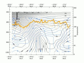
|
19 September 2005/12.00 UTC - Vertical cross section; black: isentropes, blue: relative humidity, orange thin: IR
pixel values, orange thick: WV pixel values
|
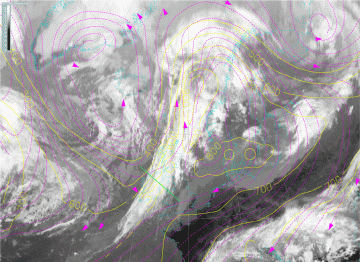
19 September 2005/12.00 UTC - Meteosat 8 IR 10.8 image; magenta: relative streams 312K - system velocity 236°
15 m/s, yellow: isobars 312K; position of vertical cross section indicated
|
|
|
There are a lot of similarities between Kata Cold Fronts and Split Fronts (see Split Front ). The main difference is the orientation between the jet and the front.
It is generally considered that a Kata Cold Front evolves from an Ana Cold Front. As baroclinic disturbances often develop over the Atlantic, the newly developed Ana Fronts can mainly be found there, whereas older, continental fronts are mostly Kata type. Another reason for the spatial differences might be that the lower parts of the front are decelerated due to the friction of the continent, while the upper parts continue with higher speed.


