18 - 19 FEBRUARY 1996 - FORECAST FOR "SPECIAL INVESTIGATION": 18 FEBRUARY 12.00 UTC TO 19.00 FEBRUARY 06.00 UTC
by ZAMG
18 February 12.00 UTC
|
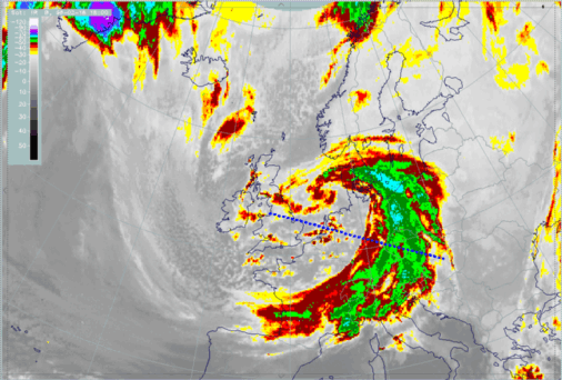
18 February 1996/18.00 UTC - Meteosat IR enhanced image; position of vertical cross section indicated
|
18 February 1996/06.00 UTC - Meteosat IR enhanced image; position of vertical cross section indicated
|
|
|
|
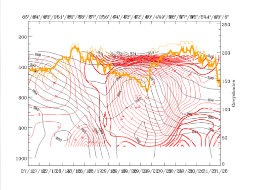
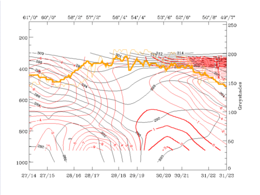
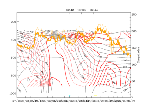
18 February 1996/12.00 UTC - Vertical cross section; black: isentropes (ThetaE), red thin: temperature advection - CA, red thick: temperature
advection - WA, orange thin: IR pixel values, orange thick: WV pixel values
|
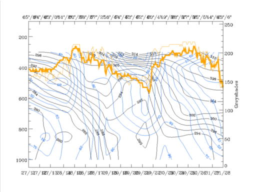
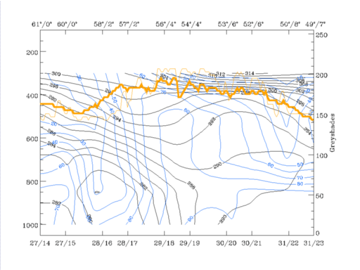
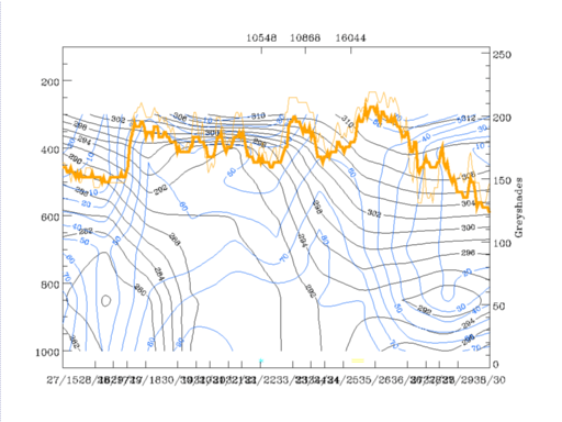
18 February 1996/12.00 UTC - Vertical cross section; black: isentropes (ThetaE), blue: relative humidity, orange thin: IR pixel values,
orange thick: WV pixel values
|
|
|
The same two surfaces as for 06.00 UTC are selected for this point of time: 290K immediately on top of the frontal crowding zone, and 300K which is in the upper part of the troposphere.
|
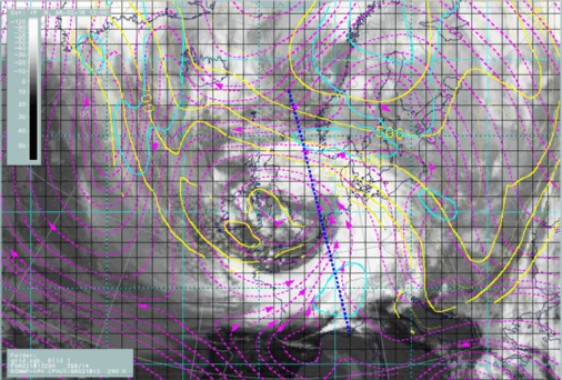
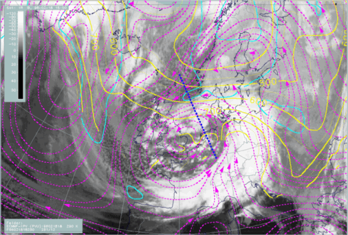
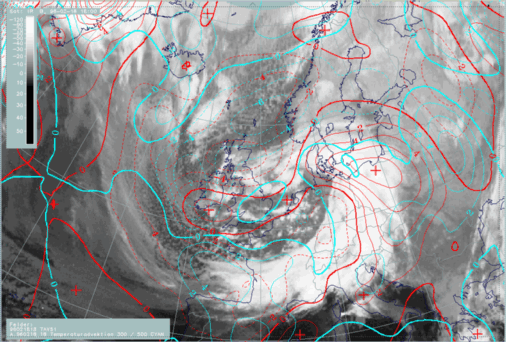
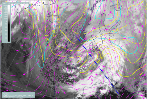
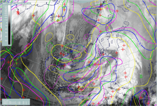
18 February 1996/12.00 UTC - Meteosat IR image; magenta: relative streams 290K - system velocity 298° 14 m/s, yellow: isobars, cyan: potential
vorticity 290K, ECMWF grid superimposed, position of vertical cross section indicated
|
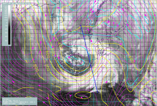
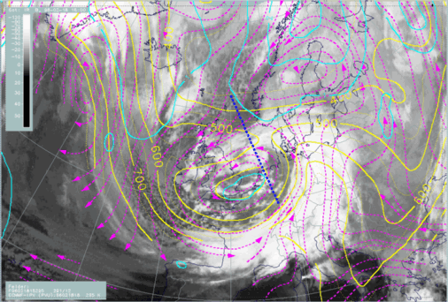
18 February 1996/12.00 UTC - Meteosat IR image; magenta: relative streams 300K - system velocity 298° 14 m/s, yellow: isobars, cyan: potential
vorticity 300K, ECMWF grid superimposed, position of vertical cross section indicated
|
|
|
Also at the high 300K level the main configuration of relative streams is similar to 06.00 UTC, with a humid stream from the back of the Cold Front and a very dry stream from northern directions forming a limiting stream line to the cloud band. In addition to the 06.00 UTC situation, a saddle point now appears in this relative stream over south-west Norway. The branch crossing the vertical cross section is from regions with very high PV values (blue) in the north bending westwards along the northern edge of the cloud spiral.
In comparison to the situation at 06.00 UTC, the advection of dry and cold air on the northern side of the Occlusion band has intensified, but no notable changes have taken place between these two times.
18 February 18.00 UTC
|
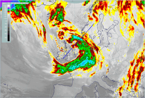
18 February 1996/06.00 UTC - Meteosat IR enhanced image; position of vertical cross section indicated
|
18 February 1996/12.00 UTC - Meteosat IR enhanced image; position of vertical cross section indicated
|

|
|
|
18 February 1996/18.00 UTC - Vertical cross section; black: isentropes (ThetaE), red thin: temperature advection - CA, red thick: temperature
advection - WA, orange thin: IR pixel values, orange thick: WV pixel values
|
18 February 1996/18.00 UTC - Vertical cross section; black: isentropes (ThetaE), blue: relative humidity, orange thin: IR pixel values,
orange thick: WV pixel values
|
|
|
|
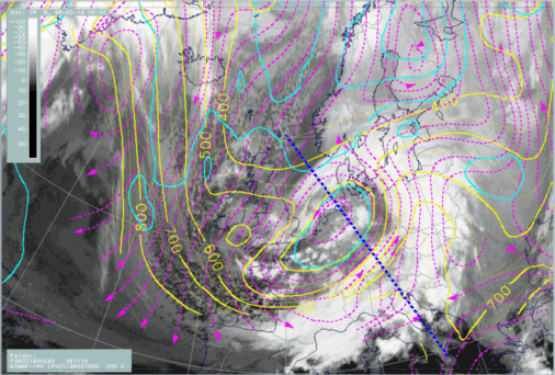
18 February 1996/18.00 UTC - Meteosat IR image; magenta: relative streams 290K - system velocity 291° 12 m/s, yellow: isobars, cyan: potential
vorticity 290K, position of vertical cross section indicated
|
18 February 1996/18.00 UTC - Meteosat IR image; magenta: relative streams 295K - system velocity 291° 12 m/s, yellow: isobars, cyan: potential
vorticity 295K, position of vertical cross section indicated
|
|
|
Compared with a classical Cold Front (compare Conceptual Models: Cold Front - Meteorological physical background ) there is a very similar situation now with two different humid and converging streams, but in the case of a classical Cold Front, both streams would originate from western not eastern directions, unlike the case here where an Occlusion band is transformed into a new Cold Front.
19 February 00.00 UTC
At 19 February 1996/00.00 UTC the process continues and the relevant parameter distribution can be followed easily from the discussions up to now.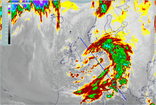
|
19 February 1996/00.00 UTC - Vertical cross section; black: isentropes (ThetaE), red thin: temperature advection - CA, red thick: temperature
advection - WA, orange thin: IR pixel values, orange thick: WV pixel values
|
19 February 1996/00.00 UTC - Vertical cross section; black: isentropes (ThetaE), blue: relative humidity, orange thin: IR pixel values,
orange thick: WV pixel values
|
|
|
|
19 February 1996/00.00 UTC - Meteosat IR image; magenta: relative streams 290K - system velocity 261° 10 m/s, yellow: isobars, cyan: potential
vorticity 290K, position of vertical cross section indicated
|
19 February 1996/00.00 UTC - Meteosat IR image; magenta: relative streams 295K - system velocity 261° 10 m/s, yellow: isobars, cyan: potential
vorticity 295K, position of vertical cross section indicated
|
|
|
Evolution from 18 February 06.00 UTC to 19 February 06.00 UTC
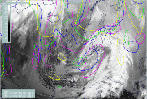
In this process of the change of an Occlusion cloud band into a Cold Front the propagation of PV values typical for stratospheric air and CA was essential. The next two images summarize this movement from 18 February 12.00 UTC until 19 February 06.00 UTC. Different colours represent different points of time: yellow: 18/12.00 UTC, green: 18/18.00 UTC, blue: 19/00.00 UTC and magenta: 19/06.00 UTC. The isoline with a PV value of one unit which separates tropospheric from stratospheric air moves from south Norway south-westwards to Scotland and central England.CA maxima show up as dashed lines in the same colours as just mentioned. Attention has to be drawn to the area of the British Isles. A CA maximum moves from north of Scotland (small yellow circle) to south England and the English Channel, widening and increasing.
|
19 February 1996/06.00 UTC - Meteosat IR image; yellow: potential vorticity 18/12.00 UTC, green: potential vorticity 18/18.00 UTC, blue:
potential vorticity 19/00.00 UTC, magenta: potential vorticity 19/06.00 UTC
|
19 February 1996/06.00 UTC - Meteosat IR image; yellow: temperature advection - CA 18/12.00 UTC, green: temperature advection - CA 18/18.00 UTC,
blue: temperature advection - CA 19/00.00 UTC, magenta: temperature advection - CA 19/06.00 UTC
|
|
|
Diagnosis for 19 February 06.00 UTC
|
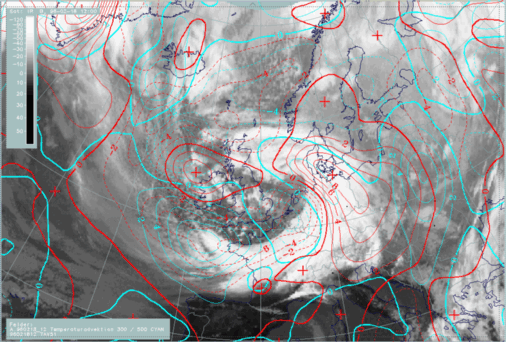
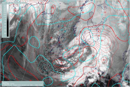
19 February 1996/06.00 UTC - Meteosat IR image; red thick: front indicator, red: height contours 1000 hPa, green: height contours 500 hPa, SatRep
overlay: names of conceptual models
|
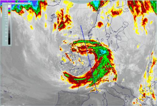
19 February 1996/06.00 UTC - Meteosat IR image; red thick: front indicator, blue: thermal front parameter (TFP), green: equivalent thickness
500/850 hPa, red: temperature advection - WA 1000 hPa, SatRep overlay: names of conceptual models
|
|
|

