18 - 19 FEBRUARY 1996 - FORECAST FOR THE WARM FRONT FOR 18 FEBRUARY 12.00 UTC AND 18.00 UTC
by ZAMG
18 February 1996/06.00 UTC - Meteosat IR image; SatRep overlay: names of conceptual models; SatRep menu: key parameters for Warm Front forecast
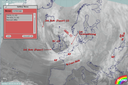
The very short range forecast VSRF (06.00 - 18.00 UTC, 12 hours)
For the very short range forecast, six-hourly forecasts from ECMWF are used, and those parameters which are key parameters of a conceptual model are prepared as overlays on the satellite image in three different colours, representing the three points of time 06.00, 12.00 and 18.00 UTC:- yellow: 06.00 UTC
- green: 12.00 UTC
- blue: 18.00 UTC
Nowcasting (0-2 hours)
For this forecast interval, atmospheric motion vectors (AMVs) are used which extrapolate the cloud systems for the next two hours. These nowcasts are renewed half-hourly or hourly and are not discussed here.
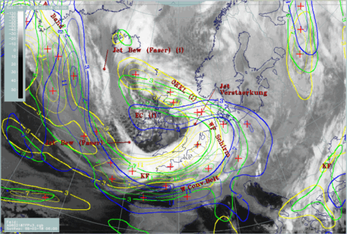
18 February 1996/06.00 UTC - Meteosat IR image; yellow: thermal front parameter (TFP) 500/850 hPa 06.00 UTC, green: thermal front parameter (TFP)
500/850 hPa 12.00 UTC, blue: thermal front parameter (TFP) 500/850 hPa 18.00 UTC

As has been mentioned in the diagnosis, the TFP field shows a trough-like feature for the maximum of the TFP where the warm front should be indicated. This feature can be followed until 18.00 UTC. At 06.00 UTC (yellow) it can be found over the Netherlands, Belgium and west Germany, at 12.00 UTC (green) over west Germany and Switzerland and at 18.00 UTC over south Germany, Austria and Croatia.
18 February 1996/06.00 UTC - Meteosat IR image; yellow: temperature advection - WA 1000 hPa 06.00 UTC, green: temperature advection - WA 1000 hPa
12.00 UTC, blue: temperature advection - WA 1000 hPa 18.00 UTC
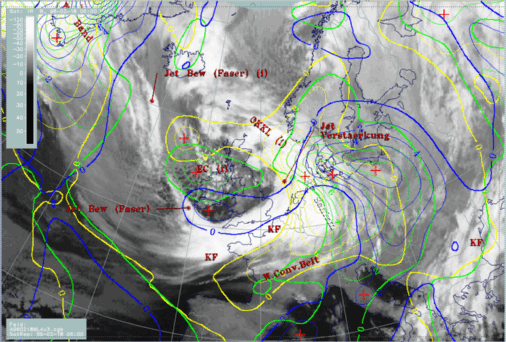
TFP as well as WA do not give indications for intensity changes, but the vertical cross sections can help with this question.
|
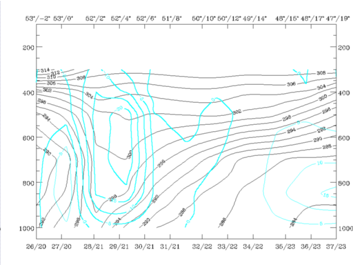
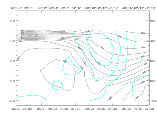
18 February 1996/06.00 UTC - Vertical cross section; black: isentropes (ThetaE), cyan thick: vertical motion (omega) - upward motion, cyan thin:
vertical motion (omega) - downward motion, orange thin: IR pixel values, orange thick: WV pixel values
|
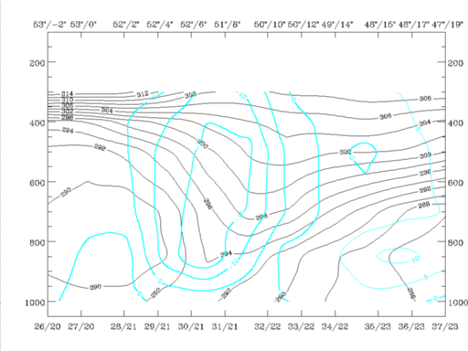
18 February 1996/12.00 UTC - Vertical cross section; black: isentropes (ThetaE), cyan thick: vertical motion (omega) - upward motion, cyan thin:
vertical motion (omega) - downward motion, orange thin: IR pixel values, orange thick: WV pixel values
|
|
|
|
|
|
18 February 1996/18.00 UTC - Vertical cross section; black: isentropes (ThetaE), cyan thick: vertical motion (omega) - upward motion, cyan thin:
vertical motion (omega) - downward motion, orange thin: IR pixel values, orange thick: WV pixel values
|
The satellite images of these three points of time confirm this decrease by showing dissolution of Warm Front cloudiness.
|
18 February 1996/06.00 UTC - Meteosat IR image;yellow: thermal front parameter (TFP) 500/850 hPa 06.00 UTC, green: thermal front parameter (TFP)
500/850 hPa 12.00 UTC, blue: thermal front parameter (TFP) 500/850 hPa 18.00 UTC
|
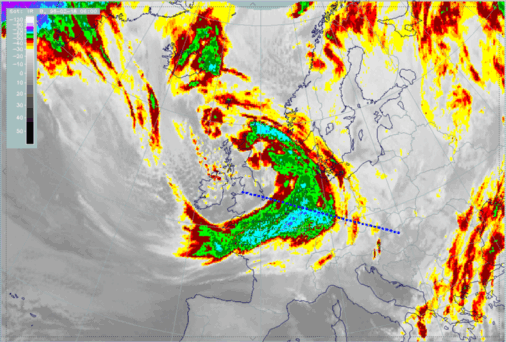
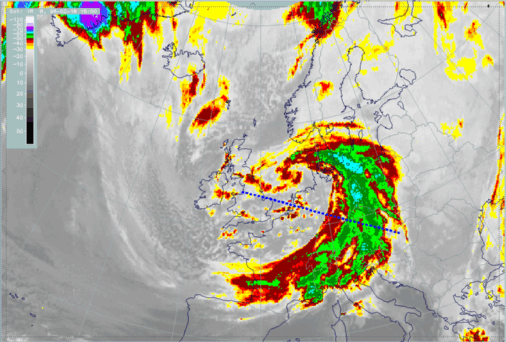
18 February 1996/06.00 UTC - Meteosat IR enhanced image; position of vertical cross section indicated
|
|
|
|
|
|
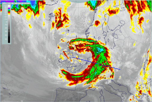
18 February 1996/12.00 UTC - Meteosat IR enhanced image; position of vertical cross section indicated
|
18 February 1996/18.00 UTC - Meteosat IR enhanced image; position of vertical cross section indicated
|


