18 - 19 FEBRUARY 1996 - FORECAST FOR THE COLD FRONT FOR 18 FEBRUARY 12.00 UTC AND 18.00 UTC
by ZAMG
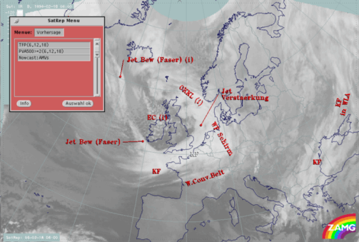
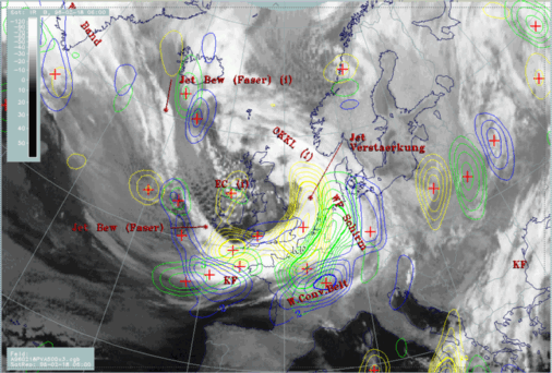
The very short range forecast VSRF (06.00 - 18.00 UTC, 12 hours)
For the very short range forecast, six-hourly forecasts from ECMWF are used, and those parameters which are key parameters of a conceptual model are prepared as overlays on the satellite image in three different colours, representing the three points of time 06.00, 12.00 and 18.00 UTC:- yellow: 06.00 UTC
- green: 12.00 UTC
- blue: 18.00 UTC
Nowcasting (0-2 hours)
For this forecast interval atmospheric motion vectors (AMVs) are used which extrapolate the cloud systems for the next two hours. These nowcasts are renewed half-hourly or hourly and are not discussed here.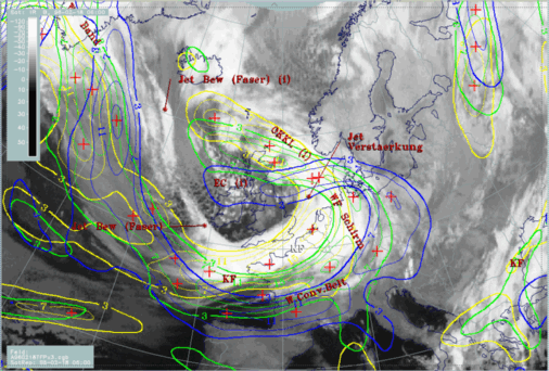
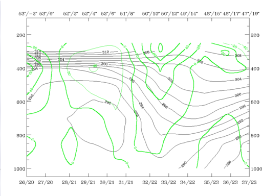
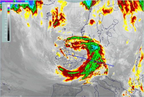
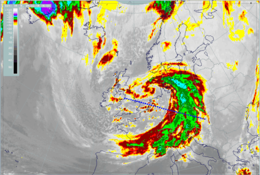
The thermal front parameter indicating location of the Cold Front is propagating very fast from the west European coast to central France and west Germany at 12.00 UTC, and south France, Switzerland and Austria at 18.00 UTC.
Estimates about intensity changes of the cloudiness using the isoline distribution of the TFP can only be made very roughly. For this, the parameter of PVA at 500 hPa is much more appropriate.
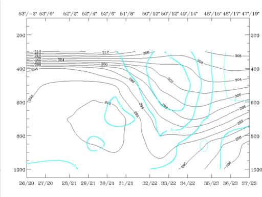
Another forecast help is to inspect the vertical cross sections computed from ECMWF forecast fields. Besides providing information about propagation, this method has the advantage of gaining insight into the changes in the vertical structure of the frontal surface.
|
18 February 1996/06.00 UTC - Meteosat IR enhanced image; position of vertical cross section indicated
|
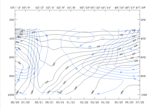
18 February 1996/06.00 UTC - Vertical cross section; black: isentropes (ThetaE), blue: relative humidity, orange thin: IR pixel values,
orange thick: WV pixel values
|
|
|
|

|
|
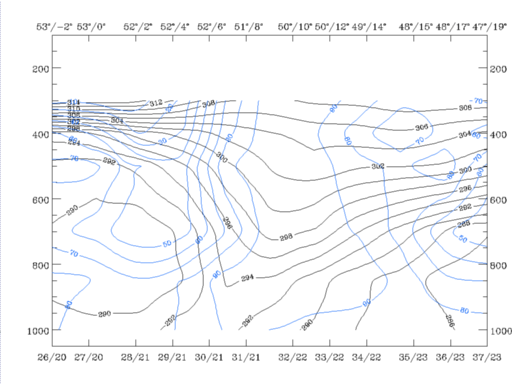
18 February 1996/12.00 UTC - Vertical cross section; black: isentropes (ThetaE), blue: relative humidity, orange thin: IR pixel values,
orange thick: WV pixel values
|
18 February 1996/18.00 UTC - Vertical cross section; black: isentropes (ThetaE), blue: relative humidity, orange thin: IR pixel values,
orange thick: WV pixel values
|
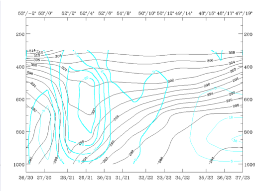
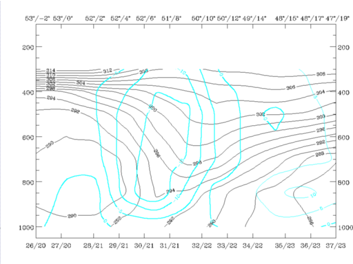
All other parameters, especially PVA and vertical motion (Omega), indicate a continuously high intensity of the eastward-moving cold front for 12.00 and 18.00 UTC. The PVA field contains at 300 hPa a pronounced maximum which is superimposed on the frontal zone as well as on the cloudiness connected to it and moves eastward. Vertical motion shows a very intensive zone of upward motion (negative values of Omega) on top of the Cold Front surface; during an increasing inclination of the crowding zone of isentropes representing the Cold Front until 18.00 UTC, the maximum of vertical motion inclines in the same way.
|
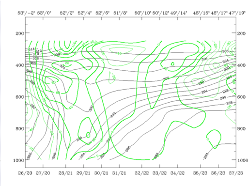
18 February 1996/06.00 UTC - Vertical cross section; black: isentropes (ThetaE), green thick: vorticity advection - PVA, green thin: vorticity
advection - NVA, orange thin: IR pixel values, orange thick: WV pixel values
|
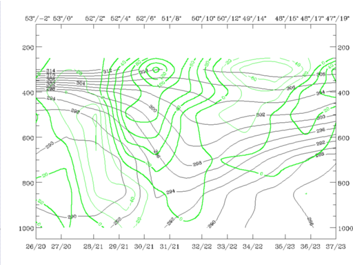
18 February 1996/12.00 UTC - Vertical cross section; black: isentropes (ThetaE), green thick: vorticity advection - PVA, green thin: vorticity
advection - NVA, orange thin: IR pixel values, orange thick: WV pixel values
|
|
|
|
|
|
18 February 1996/18.00 UTC - Vertical cross section; black: isentropes (ThetaE), green thick: vorticity advection - PVA, green thin: vorticity
advection - NVA, orange thin: IR pixel values, orange thick: WV pixel values
|
|
18 February 1996/06.00 UTC - Vertical cross section; black: isentropes (ThetaE), cyan thick: vertical motion (omega) - upward motion, cyan thin:
vertical motion (omega) - downward motion, orange thin: IR pixel values, orange thick: WV pixel values
|
18 February 1996/12.00 UTC - Vertical cross section; black: isentropes (ThetaE), cyan thick: vertical motion (omega) - upward motion, cyan thin:
vertical motion (omega) - downward motion, orange thin: IR pixel values, orange thick: WV pixel values
|
|
|
|
|
|
18 February 1996/18.00 UTC - Vertical cross section; black: isentropes (ThetaE), cyan thick: vertical motion (omega) - upward motion, cyan thin:
vertical motion (omega) - downward motion, orange thin: IR pixel values, orange thick: WV pixel values
|
|
18 February 1996/06.00 UTC - Meteosat IR enhanced image; position of vertical cross section indicated
|
18 February 1996/12.00 UTC - Meteosat IR enhanced image; position of vertical cross section indicated
|

|
|
|
|
|
18 February 1996/18.00 UTC - Meteosat IR enhanced image; position of vertical cross section indicated
|


