18 - 19 FEBRUARY 1996 - ENHANCED CUMULUS
by ZAMG
| Rel.Top. + TA=<0 | This combination gives an overview at the larger scale situation; typically ECs can be found within the thickness troughs on the rear of the Cold Front mostly within cold advection CA 500/1000 hPa |
|---|---|
| PVA500>=2 | Positive vorticity advection (PVA) at 500 hPa exceeding a threshold of 2 units (*10-9 sec-2); well developed cases show up with pronounced PVA maxima which can also be followed prognostically |
| Isot + PVA300>=3 | This is a combination of isotachs greater than 30 units (m sec-1) and positive vorticity advection (PVA) at 300 hPa exceeding 3 units (*10-9 sec-2); this combination indicates a special situation where ECs can develop, namely in the left exit region of jet streaks |
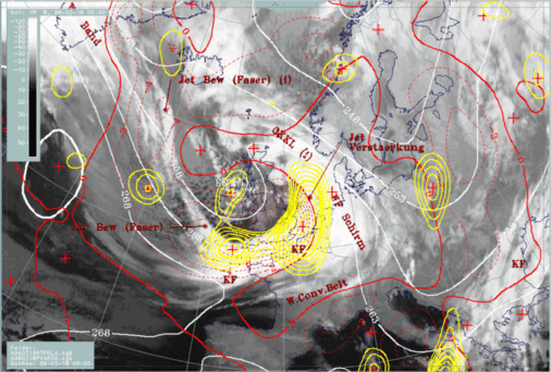
18 February 1996/06.00 UTC - Meteosat IR image; white: equivalent thickness 500/850 hPa, red thick: front indicator, red: temperature advection - CA
1000 hPa, yellow: positive vorticity advection (PVA) 500 hPa, SatRep overlay: names of conceptual models