18 - 19 FEBRUARY 1996 - INTRODUCTION AND SHORT CASE DESCRIPTION
by ZAMG
18 February 1996/06.00 UTC - Meteosat IR image; weather events (green: rain and showers, blue: drizzle, cyan: snow, purple:
freezing rain, red: thunderstorm with precipitation, orange: hail, black: no actual precipitation or thunderstorm with
precipitation)
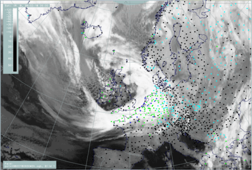
Cloud fibres stretching from Greenland across the Atlantic (approximately 58N/20W) reach the frontal cloud band west of Cornwall (50N/06W). An angle is formed between the frontal cloudiness and the fibres which is typical for the crossing of frontal cloudiness by a jet stream/streak with the fibres indicating the jet axis (compare Cloud fibre at jet axis ).
Cellular cloudiness west of England and over Ireland indicates cold air with an EC or EC-like intensified area embedded (approximately 55N/09W).
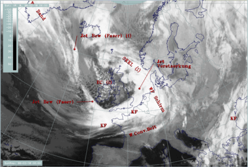
The next image shows the names of the conceptual models diagnosed within the SatRep (Satellite Report) and superimposed as a first level of SatRep on the satellite image:
- KF: Cold Front
- WF Schirm: Warm Front Shield
- OKKL: Occlusion
- Jet Verstaerkung: Jet intensification i.e. intensification of frontal cloudiness by jet streak crossing
- Jet Bew (Faser): Jet cloudiness (fibre) i.e. Cloud Fibres related to jet axis
18 February 1996/06.00 UTC - Meteosat IR image; SatRep overlay: names of conceptual models