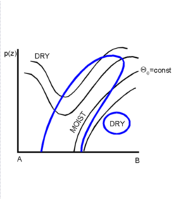
Occlusion: Warm Conveyor Belt Type - Typical Appearance In Vertical Cross Sections
by ZAMG
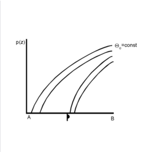
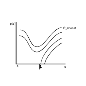
The isentropes of the equivalent potential temperature generally show a distinct trough structure indicating the warmer air which has been lifted (see Meteorological physical background) and the crowding zone of a surface front. In this case the upper level trough is forward inclined with height. The most frequent configuration is a Warm Front inclined crowding zone in front of the isentropic trough structure. The difference between the cross section of an Occlusion cloud band and of a Warm Front cloud band can be seen in the layer above the Warm Front surface: in a Warm Front case the isentropic trough configuration does not exist (see Warm Front Band, Warm Front Shield and Detached Warm Front).

|
|
|
|
|
- A Warm Front type: in this case the isentropic trough is forward inclined on top of the Warm Front zone.
- A Warm Front inclined crowding zone in front and a Cold Front inclined crowding zone behind the isentropic trough feature. In this case the forward inclination of the isentropic trough is not as strongly pronounced as in the other case. Sometimes also a straight vertical trough axis can be observed.
|
|
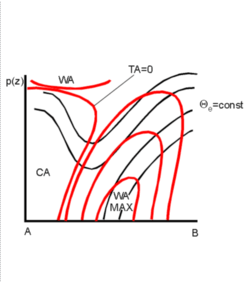
The whole area of the Warm Front inclined crowding zone and the leading part of the isentropic trough feature is under the influence of pronounced WA. The maximum of WA mostly can be found within the lower levels of the troposphere very close to the area where the Warm Front inclined crowding zone reaches the surface. A secondary pronounced area of WA can be found within the upper levels of the troposphere on the rear side of the isentropic trough. This area is typically situated at approximately 300 hPa and indicates the tropopause. The lower and mid-levels of the troposphere are characterized by pronounced CA. The zero line of temperature advection is close to the minimum of the isentropic trough in the lower and mid-levels of the troposphere. Very often the zero line in these levels is characterized by a forward inclination which leads to the development of a potentially unstable stratification of the troposphere (see Meteorological physical background and Key parameters).
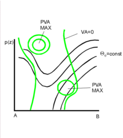
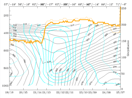
The field of vorticity advection is characterized by PVA within the whole area of the Occlusion. Typically two PVA maxima can be found in the cross section. The main maximum exists in the upper levels of the troposphere on the rear side of the isentropic trough and is connected with the left exit region of a jet streak; a weaker PVA maximum exists within the Warm Front inclined crowding zone in the lower levels of the troposphere at approximately 800 hPa. This maximum is connected with the already pronounced cyclonic circulation in these levels and indicates the propagation of the low area (see Meteorological physical background and Key parameters).
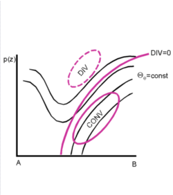
The field of divergence shows pronounced convergence within the area of the Warm Front inclined crowding zone and within the lower part of the leading area of the isentropic trough configuration. In the upper part divergence prevails. The zero line of divergence can be found very close to the trough axis.
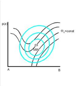
According to the distribution of convergence, temperature advection and vorticity advection, the field of vertical motion (omega) shows a wide area of strong upward motion within the area of the occlusion. The strongest upward motion typically can be found within the mid-levels of the troposphere.
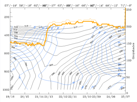
The pixel values of the satellite images in IR, VIS and WV are characterized by high values within the cloud band indicating multilevel cloudiness. The rear cloud edge in the WV image often is characterized by a sharp gradient due to the dry air which is advected within the relative stream of the dry intrusion (see Cloud structure in satellite image and Meteorological physical background).
|
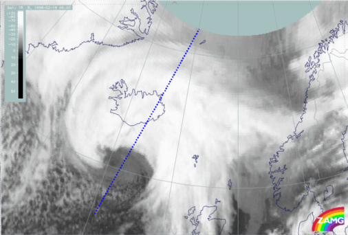
19 February 1998/06.00 UTC - Meteosat IR image; position of vertical cross section indicated
|
|
|
|
|
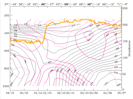
19 February 1998/06.00 UTC - Vertical cross section; black: isentropes (ThetaE), blue: relative humidity, orange thin: IR pixel values,
orange thick: WV pixel values
|
|
|
|
|
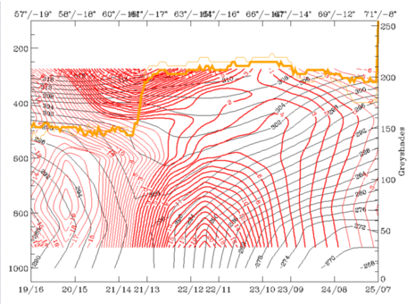
19 February 1998/06.00 UTC - Vertical cross section; black: isentropes (ThetaE), red thick: temperature advection - WA, red thin:
temperature advection - CA, orange thin: IR pixel values, orange thick: WV pixel values
|
|
|
|
|
19 February 1998/06.00 UTC - Vertical cross section; black: isentropes (ThetaE), green thick: vorticity advection - PVA, green thin:
vorticity advection - NVA, orange thin: IR pixel values, orange thick: WV pixel values
|
|
|

|
|
19 February 1998/06.00 UTC - Vertical cross section; black: isentropes (ThetaE), magenta thin: divergence, magenta thick: convergence,
orange thin: IR pixel values, orange thick: WV pixel values
|
|
|
|
|
19 February 1998/06.00 UTC - Vertical cross section; black: isentropes (ThetaE), cyan thick: vertical motion (omega) - upward motion,
cyan thin: vertical motion (omega) - downward motion, orange thin: IR pixel values, orange thick: WV pixel values
|
|
|
|


