12 MARCH 1996 - COLD FRONT
by ZAMG
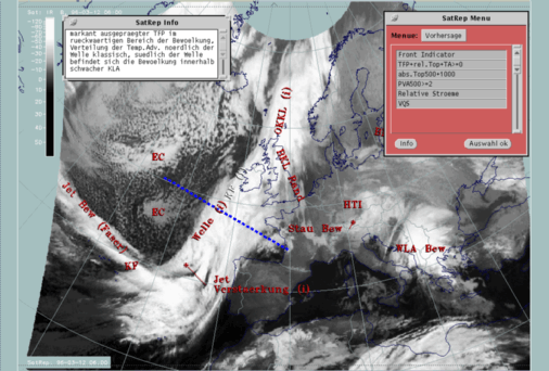
| Front Indicator | This is a line indicating the maximum of the thermal front parameter (TFP) 500/850 hPa (*10-1Km-1) |
|---|---|
| TFP + rel.Top + TA>=0 | This is a combination of the thermal front parameter (TFP) greater than 3 units, the equivalent thickness (rel.Top) 500/850 hPa (K) and warm advection (TA>=0) (K 12h-1); this combination of key parameters is especially indicative of the thermal characteristics of a Cold Front |
| TFP + Scher300=0 | This is a combination of the thermal front parameter (TFP) 500/850 hPa greater than 3 units and the zero line of shear vorticity at the 300 hPa level (Scher300=0); this combination of key parameters is indicative of the relation between front and jet stream |
| Abs.Top500 + 1000 | This is the combination of height contours at 1000 and 500 hPa (gpm); this combination of key parameters is indicative of the stream and pressure distribution near the surface and in the middle of the troposphere |
| PVA500>=2 | This parameter shows maxima of positive vorticity advection (PVA) at 500 hPa exceeding 2 units (*10-9sec-2); this key parameter indicates areas with increased possibility for more severe weather events because of increased vertical motion (compare Conceptual Models: Wave and Conceptual Models: Front Intensification by Jet Crossing ) |
| Relative Stroeme (relative streams) | This parameter shows relative streams on isentropic surfaces; relative streams are indicative of the different air masses involved in the process and of areas with sinking or rising motion; they can be used to explain cloud configurations requiring special explanation |
| VQS | Gives the location of available vertical cross sections (VQS) |
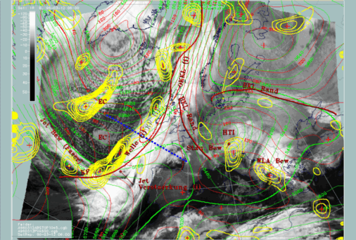
Yellow isolines enclose maxima of PVA at 500 hPa and show the high values close to the rear edge, especially in connection with the southern part of the cloud band. This situation will be discussed in detail in the special investigation (compare Diagnosis for 12 March 06.00 UTC ). Another dominant area is connected with the EC over the Atlantic and will be discussed as a separate conceptual model (compare Enhanced cumulus ).
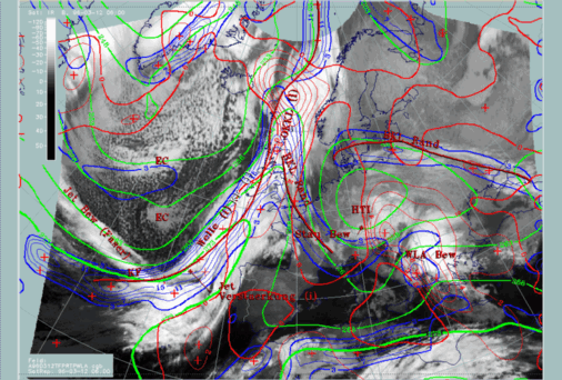
Another important tool for a deeper diagnosis of the Cold Front structure is vertical cross sections. In the first satellite image in this part the vertical cross section has been superimposed as a section line. It is in the region of the Wave bulge.
|
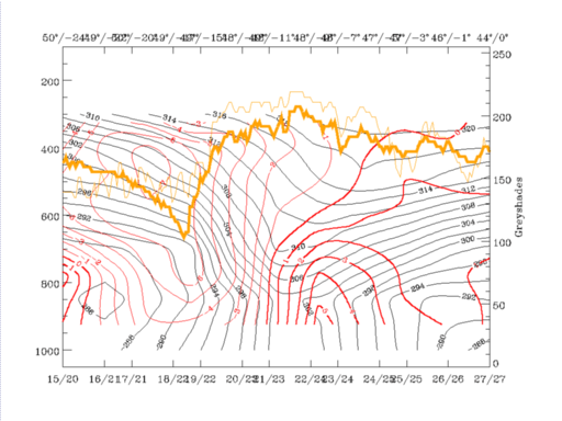
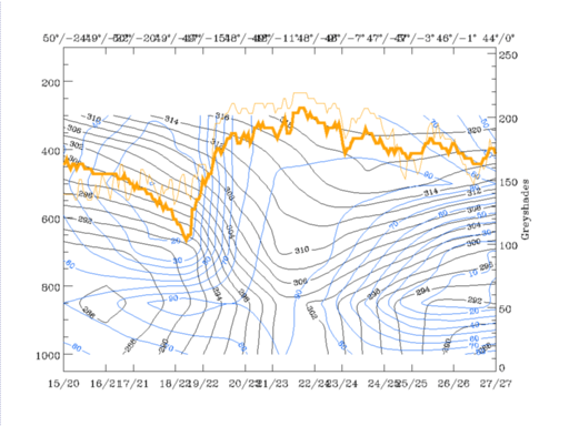
12 March 1996/06.00 UTC - Vertical cross section; black: isentropes (ThetaE), red thick: temperature advection - WA, red thin: temperature
advection - CA, orange thin: IR pixel values, orange thick: WV pixel values
|
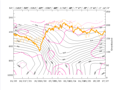
12 March 1996/06.00 UTC - Vertical cross section; black: isentropes (ThetaE), blue: relative humidity, orange thin: IR pixel values,
orange thick: WV pixel values
|
|
|
This configuration seems to be the consequence of the Wave area existing there and is confirmed by the other parameters to a certain extent. Humidity, for instance, contains high values of more than 90% reaching up to 500 hPa immediately ahead of the surface Cold Front and within and east of the trough in the isentropes and the Wave area. In contrast to this there is a steep gradient of humidity at about 49N/15W which coincides quite well with the western edge of the cloud band. This configuration has some similarities to the Kata Front type (compare Conceptual Models: Cold Front - Meteorological physical background ) where humidity and consequently cloudiness is ahead of the frontal surface, as opposed to the Ana Front type where it is inclined backwards on top of the frontal surface.
Looking at the vertical distribution of temperature advection, one can note a rather untypical situation, especially for the existence of a Wave: warm advection can only be found in front of the surface layer of the Cold Front and the Wave up to about 700 - 650 hPa, while above, there is pronounced cold advection. This would lead to the conclusion that Wave development is going on only in the lowest part of the troposphere and two different regimes are existing in two different layers, one on top of the other. Usually, such a vertical distribution with air becoming warmer in the lower layers but colder in the layers above is indicative of an unstable atmosphere. The character of cloudiness in the satellite images confirms this conclusion and, although not provable because of the location over the sea, convective weather events can be expected there.
|
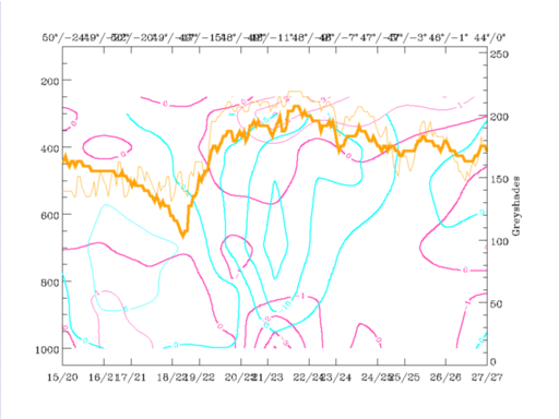
12 March 1996/06.00 UTC - Vertical cross section; black: isentropes (ThetaE), magenta thin: divergence, magenta thick: convergence, orange
thin: IR pixel values, orange thick: WV pixel values
|
12 March 1996/06.00 UTC - Vertical cross section; black: isentropes (ThetaE), magenta thin: divergence, magenta thick: convergence, cyan
thick: vertical motion (omega) - upward motion, cyan thin: vertical motion (omega) - downward motion, orange thin: IR pixel values, orange
thick: WV pixel values
|
|
|


