12 MARCH 1996 - ENHANCED CUMULUS
by ZAMG
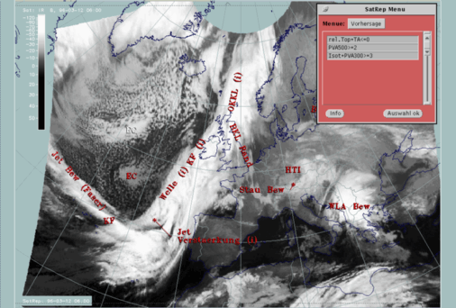
12 March 1996/06.00 UTC - Meteosat IR image; SatRep overlay: names of conceptual models, SatRep menu: key parameters for EC
Nearly the whole Atlantic area behind the Cold Front and north of the cloud fibre which crosses the Cold Front band (compare
Diagnosis for 12 March 06.00 UTC
) is filled with typical cold air cloudiness in the form of regularly shaped cloud cells. They have lower and warmer tops in the southern parts but become wider and colder to the north. This is indicative of a bigger temperature difference between water and air, and of an increasing instability in this area.
There are two specific areas where the cells form continuous regions called "EC" (Enhanced Cumuli) (compare
Conceptual Models: Enhanced Cumulus
): the main one is an elongated area around 52N/28W; a second, smaller one with untypically warm cloud tops can be identified to the south, at 46N/23W. In addition to the state of the atmosphere characteristic for the formation of cold air cloud cells, maxima of PVA exist which indicate the propagation of a small scale trough or a jet streak.
As can be seen in the SatRep Menu window, the characteristic key parameters and key parameter combinations are:
| Rel.Top. + TA=<0
|
This combination gives an overview of the bigger scale situation; typically ECs can be found within the thickness troughs on the rear of the
Cold Fronts mostly within cold advection (CA) (K12h-1)
|
| PVA500>=2
|
Positive vorticity advection (PVA) exceeding a threshold of 2 units (*10-9sec-2) at 500 hPa; well-developed cases show
up with pronounced PVA maxima which can also be followed prognostically
|
| Isot + PVA300>=3
|
This is a combination of isotachs at 300 hPa greater than 30 units (ms-1) and positive vorticity advection (PVA) at 300 hPa
exceeding 3 units (*10-9sec-2); this combination indicates a special situation where ECs can develop, namely in the left
exit region of jet streaks
|
12 March 1996/06.00 UTC - Meteosat IR image; red thick: front indicator, red: temperature advection - CA 1000 hPa, green: equivalent thickness 500/850
hPa, yellow: positive vorticity advection (PVA) 500 hPa; SatRep overlay: names of conceptual models
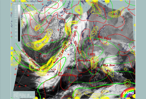
The combination of thickness (white) and temperature advection (red) shows first of all the typical synoptic scale structure with both a main thickness trough and a big area of cold advection (dashed red lines) in the area of ECs. In this special case thickness contains also a fine scale structure with two small scale troughs superimposed upon the synoptic scale trough exactly where the ECs exist. The yellow lines show maxima of positive vorticity advection at 500 hPa exceeding a threshold of 2 units. The bigger, brighter and more north-western EC is under the influence of pronounced PVA, while the EC with the warmer tops is not connected with isolines. But the latter statement is only a consequence of the chosen threshold; taking into account the whole field of vorticity advection at 500 and 300 hPa clearly reveals that there is a second relative maximum of PVA related to the EC with the warmer tops. Both PVA maxima indicate the approach of small scale upper level troughs and the advection of curvature vorticity.
|
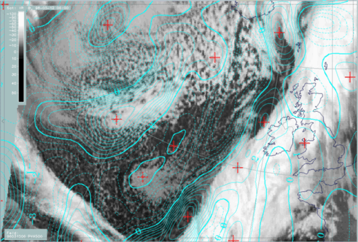
12 March 1996/06.00 UTC - Meteosat IR image; cyan: positive vorticity advection (PVA) 500 hPa
|
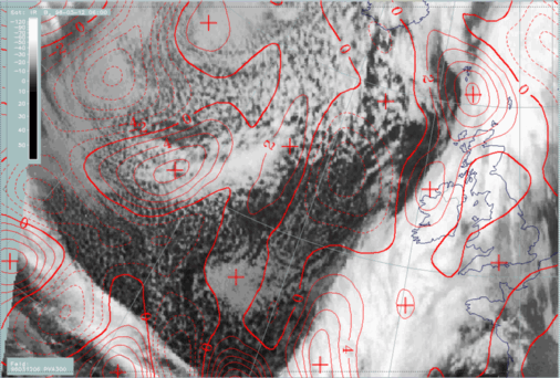
12 March 1996/06.00 UTC - Meteosat IR image; red: positive vorticity advection (PVA) 500 hPa
|
|
|
|
PVA maxima in connection with EC cloudiness show that there is additional rising caused by the contribution of PVA to the Omega-equation. In this context it should be repeated (compare
Conceptual Models: Enhanced Cumulus - Meteorological physical background
) that from the theoretical point of view it is not the maximum of PVA in upper levels that causes upward motion but the increase of vorticity advection with height; from the practical point of view and the experience in satellite meteorology, the PVA maxima restricted to the upper levels can be inspected if an increase of wind speed with height is assumed. This assumption is a reasonable one which can be supported by experience from vertical cross sections; nevertheless there might be cases where it is not fulfilled.
Experience in satellite meteorology furthermore shows that those PVA maxima at 500 and/or 300 hPa are very appropriate for a forecast of EC cloudiness during the next 12 hours (compare
Forecast for Enhanced Cumulus
).