12 MARCH 1996 - BAROCLINIC BOUNDARY TO UPPER LEVEL LOW
by ZAMG
|
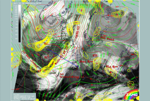
12 March 1996/06.00 UTC - Meteosat IR image; red thick: front indicator, red: height contours 1000 hPa, green: height contours 500 hPa,
yellow: positive vorticity advection (PVA) 500 hPa, SatRep overlay: names of conceptual models, position of vertical cross section indicated
|
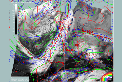
12 March 1996/06.00 UTC - Meteosat IR image; red thick: front indicator, blue: thermal front parameter (TFP) 500/850 hPa, green: equivalent
thickness 500/850 hPa, red: temperature advection - WA 1000 hPa, SatRep overlay: names of conceptual models
|
|
|
Although the cloudiness originates in the main cloud band, it cannot be analysed as a Warm Front because it leaves the influence of this synoptic regime very soon and becomes related to the south-western part of the huge Upper Level Low. This is clearly confirmed by the thickness and the TFP, (green and blue lines), which both show the cyclonic curvature connected with the Upper Level Low. This would be very untypical for a Warm Front connected with the main Cold Front.
Another parameter that supports this assumption is temperature advection (red lines). There is no WA maximum superimposed on the cloud band in front of the TFP but rather CA which is concentrated in the western and central part of the upper level low. WA can only be found within the main Cold Front band and, as is usual, on the eastern half of the Upper Level Low.
Consequently, this substructure connected with the main Cold Front band seems to be a separate cloud feature which is not predominately influenced by the physical state of the frontal system Instead, it forms the Baroclinic Boundary to the Upper Level Low, which of course is responsible for the formation of a distinct thickness gradient between the thickness ridge ahead of the main Cold Front and the minimum of the Upper Level Low. Cloudiness forming in this front - like zone undergoes the cyclonic circulation of the Upper Level Low.


