Enhanced Cumulus - Meteorological Physical Background
by KNMI, ZAMG and DHMZ
- Increased vertical instability in the troposphere;
- PVA maxima
- either immediately in front of the upper level trough, where the air parcels are under the influence of strong cyclonic rotation and PVA indicates a moving trough
- or in the left exit region of a jet streak where PVA indicates the advection of more cyclonic shear
Potential Instability
Instability can be generated in several different ways. Two possibilities are mentioned here:
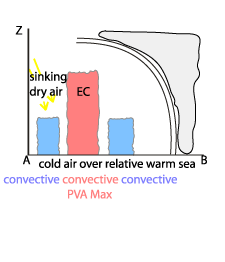
Cold air streaming over warm sea water
This type mostly occurs in autumn and winter. The cold air streaming over the sea surfaces is heated from below, due to the relatively warm water temperatures in comparison to the air (diabatic heating). As a consequence of this heating the atmosphere becomes unstable and lifting, with additional condensation, takes place. This additional condensation leads to the release of latent heat. According to the omega equation, latent heat will force vertical motion. Therefore more condensation will take place, because of the cooling of the air by upward vertical motion.On the other hand, the upper levels of the troposphere are characterised by sinking dry air, which may even originate from the stratosphere. Looking at the situation on isentropic surfaces, this sinking motion is caused by the relative stream of the dry intrusion. Therefore the upward motion in the convective cells is restricted from above and after some time an equilibrium between upward motion (represented by the cloud cells) and downward motion (indicated by the cloud-free areas in between) develops, resulting in large areas filled up with the so-called cellular Cold Air Cloudiness (see Cloud structure in satellite image).
Cold air streaming over warm land surface
This type mostly occurs in spring and summer, when cold air flows over a warmed land surface.For the development of ECs within a cold air mass, additional dynamical forcings plays a significant role.
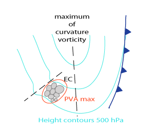
Vorticity Advection
Curvature Vorticity and its advection
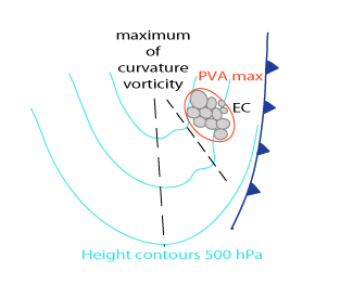
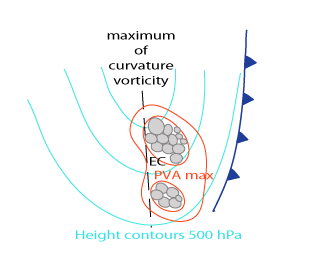
ECs usually appear immediately in front of an upper level trough, but they can also appear immediately in front of the main upper level trough as well as behind it if there is a secondary small trough.At the downstream side of the trough axis positive vorticity advection appears. In the area of the maxima of positive vorticity advection the development of Cold Air Cloudiness into EC is likely to occur. Usually those mesoscale PVA maxima are connected to secondary troughs within the synoptic scale upper level trough.
|
EC in the area of maximum positive vorticity advection at the leading edge of a small trough preceding a pronounced upper level trough
|
EC in the area of maximum positive vorticity advection in front of a pronounced upper level trough
|
|
|
|
|
|
EC in the area of maximum positive vorticity advection at the leading edge of a small trough behind the main upper level trough
|
|
|
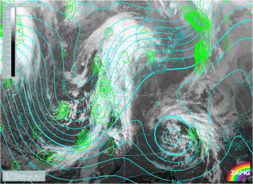
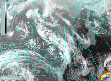
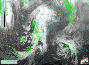
13 January 2008/12.00 UTC - Meteosat 9 IR10.8 image; cyan: height contours 500 hPa, green: vorticity advection 500 hPa
|
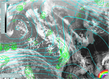
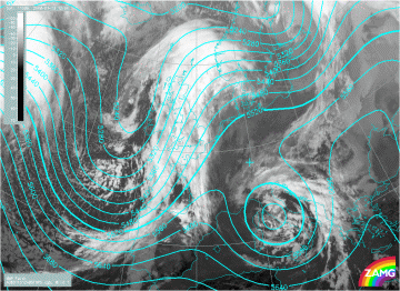
24 April 2008/12.00 UTC - Meteosat 9 IR10.8 image; cyan: height contours 500 hPa, green: vorticity advection 500 hPa
|
|
|
Shear Vorticity
EC and Cb clusters often develop in the left exit of a jet streak. The left exit of the jet is on the cyclonic side of the jet. Upstream from the left exit there is a maximum of positive or cyclonic shear vorticity. As a consequence of the movement of the jet, a vorticity advection maximum will be found in the left exit of the jet. This maximum will lead to divergence in the upper levels of the troposphere, resulting in upward motion at middle levels (see Front Intensification by Jet Crossing ).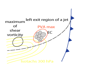
|
24 April 2008/12.00 UTC - Meteosat 9 IR10.8 image; cyan: height contours 500 hPa
|
24 April 2008/12.00 UTC - Meteosat 9 IR10.8 image; yellow: isotachs 500 hPa, green: Positive vorticity advection 500 hPa
|
|
|
|
|
|
24 April 2008/12.00 UTC - Meteosat 9 IR10.8 image; yellow: isotach 300 hPa, red: positive vorticity advection 300 hPa;
|
13 January 2008/12.00 UTC - Meteosat 9 IR10.8 image; cyan: height contours 500 hPa
|
|
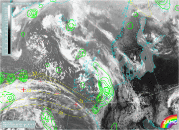
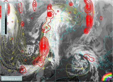
13 January 2008/12.00 UTC - Meteosat 9 IR10.8 image; yellow: isotachs 500 hPa, green: vorticity advection 500 hPa
|
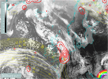
13 January 2008/12.00 UTC - Meteosat 9 IR10.8 image; yellow: isotach 300 hPa, red: Positive vorticity advection 300 hPa
|
|
|
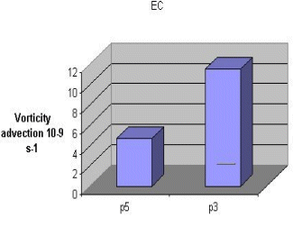
Looking at PVA maxima as additional driving factors for the development of EC cloud, the increase of PVA with height is the most important factor in the development of ECs. Most cases show a PVA maximum between 700 hPa and 300 hPa, and because of this it more usually seen on 500 hPa than on 300 hPa. This differential vorticity advection causes divergence in the upper levels resulting in upward motion at mid levels of the troposphere. Most cases show a maximum vertical motion of -18 hPa/h. The average level of minimum vertical motion is around 600 hPa.
Mean vorticity advection of 30 investigated cases. P5 = vorticity advection at 500 hPa, P3 = vorticity advection at 300 hPa.