Enhanced Cumulus - Key Parameters
by KNMI, ZAMG and DHMZ
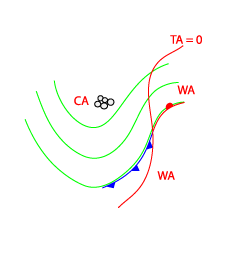
- Equivalent thickness and temperature advection at 700 hPa:
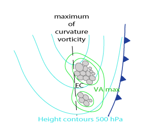
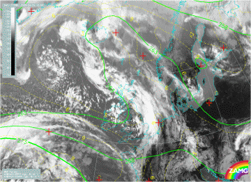
In the area of EC the equivalent thickness is marked by a trough or a minimum, indicating cold air. This is an area of relatively low ThetaW values at 850 hPa. Usually this is also an area of synoptic scale CA; but there is no distinct relation between an EC and a CA maximum; ECs can also be in areas of smaller scale WA (for instance in connection with a following Warm Front system) - Height contours at 500 hPa:
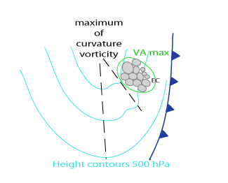
EC and Cb Cluster features are connected to upper level troughs; many of them develop ahead of embedded smaller, rapidly moving upper level troughs. This happens usually at the leading edge of the trough. If ECs are at the rear side of troughs they are in an area of high shear and are connected to jet streaks. - Isotachs:
ECs and Cb Clusters often develop at the left exit region of a strong jet streak. This is often close to the rear of the upper level trough - Positive Vorticity Advection (PVA) at 500 and 300 hPa:
Vorticity advection shows maxima at 500 and 300 hPa; vorticity advection generally increases in the layer between 500 and 300 hPa. - Instability indices:
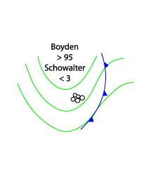
EC and Cb cluster appear in areas of instability characterised by the Boyden Index (>95) or the Showalter index (<3); but the values are typically less unstable than in the warm air ahead of fronts.
Equivalent thickness and temperature advection at 700 hPa
|
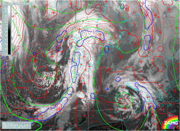
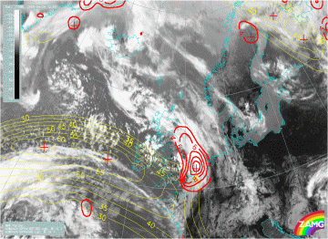
13 January 2008/12.00 UTC - Meteosat 9 IR10.8 image; green: equivalent thickness 500/850 hPa, blue: thermal front parameter 500/850 hPa,
red: temperature advection 700 hPa
|
|
|
|
|
|
|
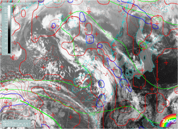
24 April 2008/12.00 UTC - Meteosat 9 IR10.8 image; green: equivalent thickness 500/850 hPa, blue: thermal front parameter 500/850 hPa,
red: temperature advection 700 hPa
|
Height contours and Vorticity Advection at 500 and/or 300 hPa
|
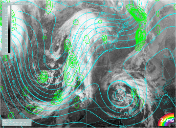
13 January 2008/12.00 UTC - Meteosat 9 IR10.8 image; cyan: height contours 500 hPa, green: vorticity advection 500 hPa
|
|
|
|
|
|
|
24 April 2008/12.00 UTC - Meteosat 9 IR10.8 image; cyan: height contours 500 hPa, green: vorticity advection 500 hPa
|
Isotachs and PVA at 500 and/or 300 hPa
|
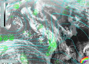
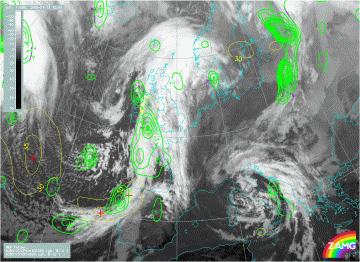
24 April 2008/12.00 UTC Meteosat 9 IR10.8 image; yellow: isotachs 500 hPa, green: vorticity advection 500 hPa
|
|

|
|
|
|
|
24 April 2008/12.00 UTC - Meteosat 9 IR10.8 image; yellow: isotachs 300 hPa, red: voriticity advection 300 hPa
|
|
13 January 2008/12.00 UTC Meteosat 9 IR10.8 image; yellow: isotachs 500 hPa, green: voriticity advection 500 hPa
|
|
|
|
|
|
|
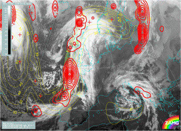
13 January 2008/12.00 UTC - Meteosat 9 IR10.8 image; yellow: isotachs 300 hPa, red: voriticity advection 300 hPa
|
Instability
|
24 April 2008/12.00 UTC - Meteosat 9 IR10.8 image; green: equivalent thickness 500/850 hPa, yellow: Showalter index
|
|
|
|

|
|
|
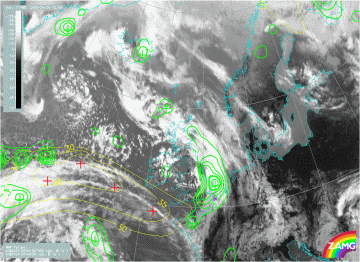
13 January 2008/12.00 UTC - Meteosat 9 IR10.8 image; green: equivalent thickness 500/850 hPa, yellow: Showalter index
|


