12 MARCH 1996 - DIAGNOSIS 12 MARCH 06.00 UTC
by ZAMG
- Wave
- Cloud Fibre at jet axis
- Intensification of Cold Front through jet crossing
Diagnosis of conceptual model "Wave": 12 March 1996/06.00 UTC
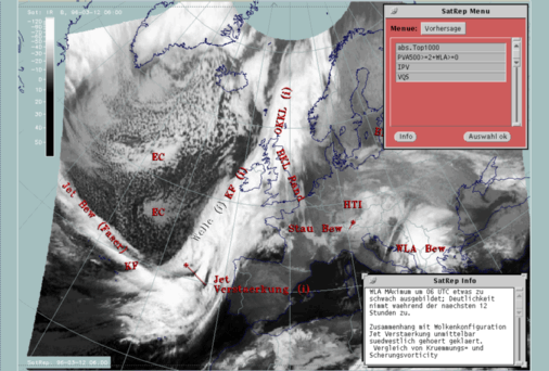
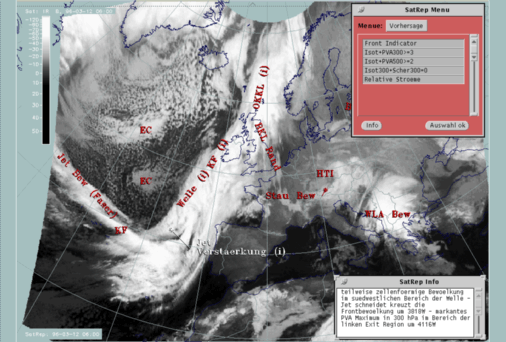
| ABSTOP1000 + PVA500>=2 + WLA | This is a commonly used combination of three parameters typically indicative of a wave:
|
|---|---|
| PV | Represents isentropic potential vorticity (*10-6m2Ksec-1kg-1) on several levels |
| VQS | Gives the location of available vertical cross sections (VQS) |
In the case of a well-developed wave, the satellite image shows a cloud bulge towards the cold air which indicates the cyclonic circulation and consists of thick intensive cloudiness. This is a result of upward motion caused by several processes of which PVA indicates only one. In this particular case, the cloud bulge in the area of the analysed Wave is rather weak. Consequently, the written information in the window addresses two points:
- WA is not very well developed for 06 UTC but becomes more distinct during the next two hours.
- The connection with the "Front Intensification by Jet Crossing" immediately south of it should be clarified.
|
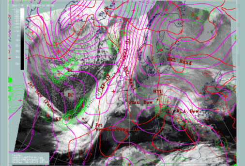
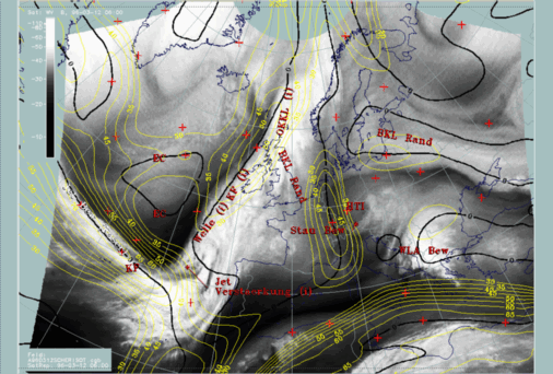
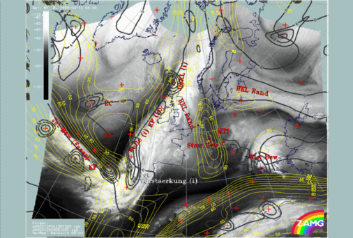
12 March 1996/06.00 UTC - Meteosat IR image; magenta: height contours 1000 hPa, green: positive vorticity advection (PVA) 500 hPa, red: warm
advection 1000 hPa; SatRep overlay: names of conceptual models
|
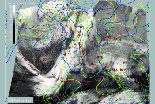
12 March 1996/06.00 UTC - Meteosat IR image; yellow: warm advection 1000 hPa 06.00 UTC, green: warm advection 1000 hPa 12.00 UTC, blue: warm
advection 1000 hPa 18.00 UTC; SatRep overlay: names of conceptual models
|
|
|
Consequently, this is an example where key parameters clearly indicate the existence of the conceptual model "Wave" but either the situation is weak and/or in an initial stage, or the numerical model does not reproduce the situation correctly, probably because of a lack of data over the Atlantic. So this is an example where the knowledge about a conceptual model can be used to interpret an uncertain, or even incorrect, numerical model, considering the actual cloud configuration in the satellite image.
For further development and a more detailed analysis with respect to the "Front Intensification" to the south, look at the relevant sections of "forecast" and "discrimination" within this chapter.
Diagnosis of "Cloud Fibre at Jet Axis" for 12 March 06.00 UTC
|
12 March 1996/06.00 UTC - Meteosat IR image; SatRep overlay: names of conceptual models, SatRep menu: key parameters for Cloud Fibre
|
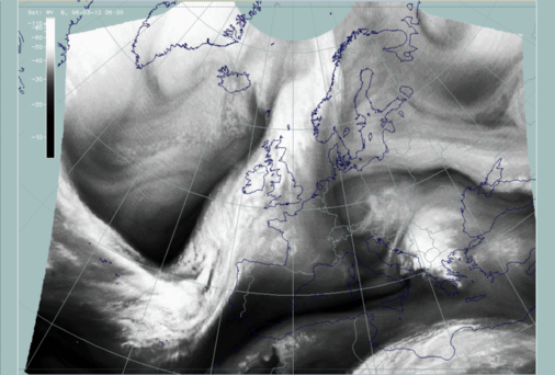
12 March 1996/06.00 UTC - Meteosat WV image
|
|
|
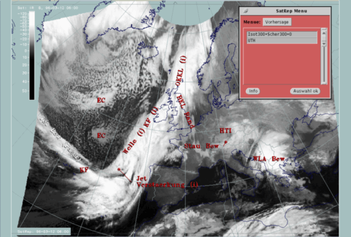
| Isot300 + Scher300=0 | This is the combination of isotachs at 300 hPa greater than 30 units (msec-1) representing the jet stream and jet streaks at a level which is very representative for jets, and the zero line of shear vorticity which marks the jet axis according to the definition of a jet |
|---|---|
| UTH | Upper tropospheric humidity (%), a parameter that is derived from the WV imagery and can in addition to the WV imagery emphasize the dry stripes on the cyclonic side of the jet streak |
It is well known that narrow Cloud Fibres consisting of only high cloudiness can develop close to the jet axis, but only on its anticyclonic side (compare Conceptual Models: Jet Cloudiness (Fibre) ). In this case a very well-developed situation is presented. The Cloud Fibre extends across the Atlantic approximately from 43N/40W nearly perpendicular to the frontal cloud band. It is rather broad compared to other cases and structured, which can be interpreted as the consequence of different effects at different height levels. The WV image shows a distinct Black Stripe on the cyclonic side of the cloud structure.
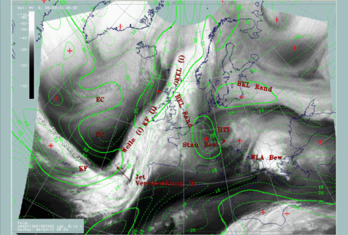
The whole situation is not only indicative of the existence of a jet streak and the orientation of its axis, but also of some interaction between this streak and the frontal cloud band. This is discussed as the next topic.
Diagnosis for conceptual model "Front Intensification by Jet Crossing" for 12 March 06.00 UTC
| Front Indicator | This is a line indicating the maximum of the thermal front parameter (TFP) 500/850 hPa (*10-1Km-1) |
|---|---|
| Isot + PVA300>=3 | This is a combination of isotachs at 300 hPa greater than 30 units (m sec-1) and positive vorticity advection (PVA) at 300 hPa exceeding 3 units (*10-9sec-2) |
| Isot + PVA500>=2 | This is a combination of isotachs at 500 hPa greater than 30 units (m sec-1) and positive vorticity advection (PVA) at 500 hPa exceeding 2 units (*10-9sec-2); both parameter combinations locate the exit region and the PVA maximum in relation to the frontal cloud band |
| Isot300 + Scher300=0 | This parameter combination shows the isotachs at 300 hPa greater than 30 units (m sec-1) and the zero line of shear vorticity which marks the jet axis; one can get information about the existence and strength of jet streaks and the course of the jet axis |
| Relative Stroeme (relative streams) | This parameter shows relative streams on isentropic surfaces; relative streams are indicative of the different air masses involved in the process and of areas of sinking or rising motion; they can be used to explain cloud configurations requiring special explanation |
The satellite image shows a cloud area with a distinct lumpy structure within the frontal cloud band immediately north of the crossing jet fibre. This is a cloud feature which typically represents increased frontal cloudiness and intensity in the left exit region of a jet streak which is superimposed on the cloud band (compare Conceptual Models: Front Intensification by Jet Crossing ). The information contained in the window draws attention to this area.
Although both maxima are in the left exit region of the jet streak there is no good correspondence with the cloud mass of the "Jet Intensification". The western maximum is located too far to the south-west of the relevant increased cloud area, and the eastern one splits into two maxima with the northern one very close to the Wave area and the southern one east of the increased cloud area of the "Jet Intensification".
Because of the close proximity of cloudiness belonging on the one hand to the Wave and on the other hand to the Jet Intensification, this situation should be clarified in more detail with help of additional parameters. The aim of this special investigation is to find out if different conceptual models can be separated, which is necessary especially for the forecast, and/or if model errors can be detected. These investigations are described in the next section.


