12 MARCH 1996 - DISCRIMINATION BETWEEN CONCEPTUAL MODELS "WAVE" AND "FRONT INTENSIFICATION BY JET STREAK CROSSING"
by ZAMG
|
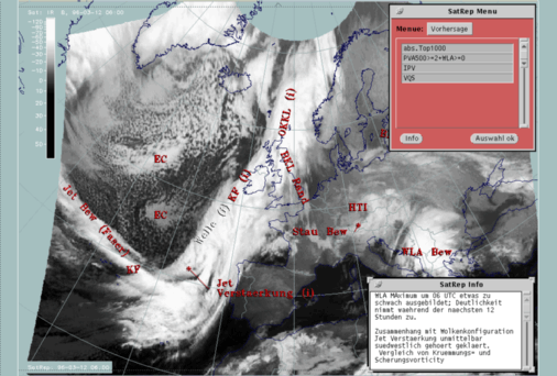
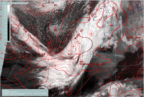
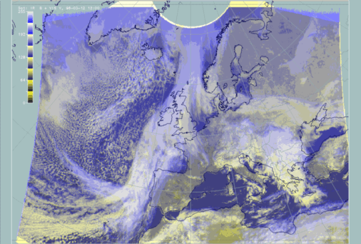
12 March 1996/06.00 UTC - Meteosat IR image; SatRep overlay: names of conceptual models, SatRep menu: key parameters for Wave
|
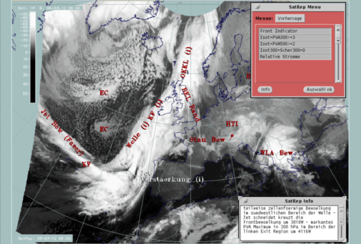
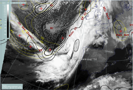
12 March 1996/06.00 UTC - Meteosat IR image; SatRep overlay: names of conceptual models, SatRep menu: key parameters for Jet Intensification
|
|
|
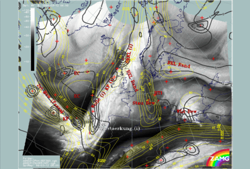
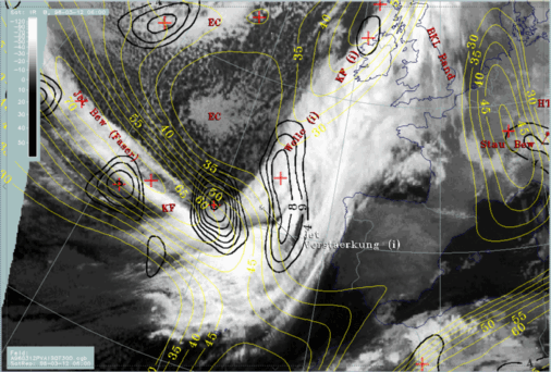
Appropriate key parameters are curvature and shear vorticity which should be able to distinguish between effects from circulation and from jet streaks; the first are regarded as more dominant for a Wave, the latter as more dominant for Front Intensification cases.
|
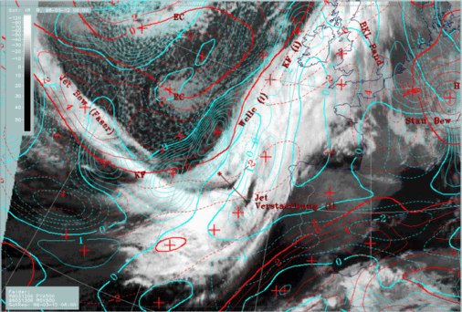
12 March 1996/06.00 UTC - Meteosat WV image; yellow: isotachs 300 hPa, black: positive vorticity advection (PVA) 300 hPa, black: shear vorticity
300 hPa; SatRep overlay: names of conceptual models
|
|
|
|
|
|
|
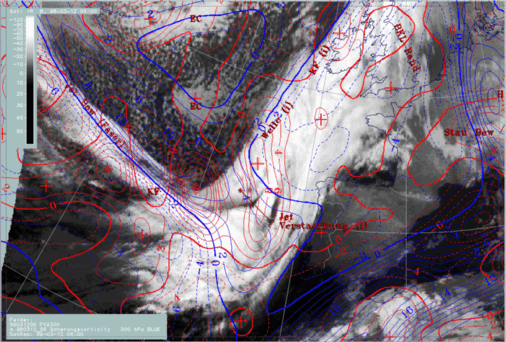
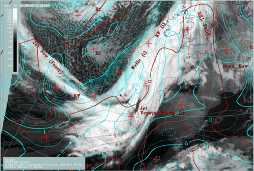
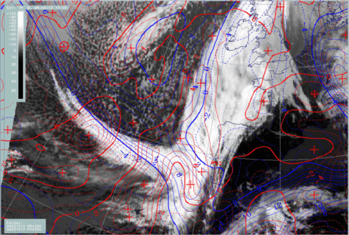
12 March 1996/06.00 UTC - Meteosat IR image; red: positive vorticity advection (PVA) 300 hPa, blue: shear vorticity 300 hPa; SatRep overlay:
names of conceptual models
|
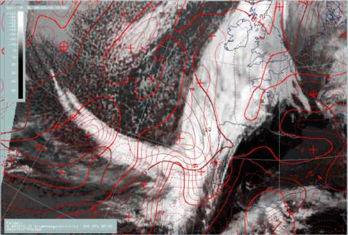
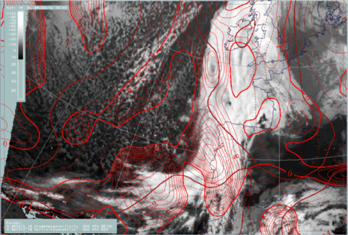
12 March 1996/06.00 UTC - Meteosat IR image; red: positive vorticity advection (PVA) 300 hPa, brown: curvature vorticity 300 hPa; SatRep overlay:
names of conceptual models
|
The different PVA maxima can be easily distinguished now. While the western maximum around 40N/20W is clearly related to the shear vorticity maximum (left image, blue isolines) and therefore indicates the left exit region, the northern maximum around 44N/15W is clearly related to the curvature maximum (right image, brown lines).The southern maximum of PVA around 40N/14W is related to a secondary shear vorticity maximum around 38N/14W. This is an indication of a south-eastward bend of the isotachs there.
After separating the different processes, the fact remains that the PVA maxima caused by shear are not consistent with the relevant area of typical cloud structure which can be diagnosed in the image. Therefore on concludes that the numerical model may not be quite correct here. Cloud structure in satellite images as a key parameter for the relevant conceptual model may help to get information about this. In both images, IR and WV, the cloud fibre crossing the cloud band of the Cold Front, which is an indication of the jet axis, can be continued as a straight line from W to E; compared to this the jet streak deviates in the area of the frontal cloud band in south-eastward directions causing the second, southern PVA maximum. This deviation could be an indication of a model error there. A shift of the isotachs from south-eastward to more eastward directions approximately along the cloud fibre would lead to a northward shift of the PVA maximum and a much better coincidence with the intensified frontal structure.
So at this point in time two decisions could be drawn from the additional parameters:
- A clear separation between shear and curvature effects which leads to a separation between the relevant cloud systems
- The assumption of a model error which shows a south-westward deviation of the jet streak over the area of the frontal cloud band leading to a shift of the PVA maxima; for this decision the form of the cloud fibre as a sign of the jet axis was used.
|
12 March 1996/06.00 UTC - Meteosat IR image; yellow: isotachs 500 hPa, black: positive vorticity advection (PVA) 500 hPa; SatRep overlay: names
of conceptual models
|
|
|
|
|
|
|
12 March 1996/06.00 UTC - Meteosat IR image; cyan: positive vorticity advection (PVA) 500 hPa, red: shear vorticity 500 hPa; SatRep overlay:
names of conceptual models
|
12 March 1996/06.00 UTC - Meteosat IR image; cyan: positive vorticity advection (PVA) 500 hPa, brown: curvature vorticity 500 hPa; SatRep overlay:
names of conceptual models
|
- The jet streak is in the western part of the cloud fibre to the south of the cloudiness; an explanation may be that the level is lower because cloudiness would be on the cyclonic side of the 500 hPa jet streak.
- In contrast to the jet streak at 300 hPa, the jet streak at the 500 hPa level turns to the north-east along the rear side of the Cold Front cloud band.
There are two main PVA maxima: one around 44N/19W and a southern one around 40N/21W. A comparison with shear vorticity (left panel) and curvature vorticity (right panel) clearly shows that curvature is the main cause for both PVA maxima. Shear is rather weak and contributes to both PVA maxima just to a minor degree.
12 March 12.00 UTC
At this point of time the cloud bulge of the wave is more pronounced than before and can be noticed from approximately 45N/14W, stretching northwards close to the west coast of Ireland.
Cloudiness in this area is only partly thick and/or multilayered whereas close to the western boundary of the Wave cloudiness only high cloudiness can be observed.
The region of the cloud fibre crossing the frontal cloud band and producing thereby a front intensification in the left exit region shows a very impressive difference between the high cloud fibre coloured in blue and the light yellow area immediately north of the fibre in the frontal cloud band (around 42N/13W). Concluding from the colour, this area can be regarded as a thick or at least multilayered area typical of the conceptual model "Jet Intensification". The cloud fibre shows at this time a slight cyclonic curvature and seems to cross the frontal cloud band immediately south of 40N turning southwards at the coast of Portugal.
As at 06.00 UTC also at this point of time the conceptual models "Wave" and "Jet Intensification" are close together and a separation of the two systems with the help of other key parameters is of interest.
|
12 March 1996/12.00 UTC - Meteosat IR image; yellow: isotachs 300 hPa, red: positive vorticity advection (PVA) 300 hPa
|
|
|
|
|
|
|
12 March 1996/12.00 UTC - Meteosat IR image; red: positive vorticity advection (PVA) 300 hPa, blue: shear vorticity 300 hPa
|
12 March 1996/12.00 UTC - Meteosat IR image; red: positive vorticity advection (PVA) 300 hPa, brown: curvature vorticity 300 hPa
|
- A northern one at the rear edge of the frontal cloud band between 48N/14W and 52N/12W which is related to the Wave area
- A southern one split up into two secondary maxima at approximately 41N/14W and 38N/10W which should belong to the area of the increased frontal cloudiness in the left exit region of the jet streak.
The interpretation of the two images containing shear and curvature vorticity leads at first to similar results as derived at 06.00 UTC. For the northern PVA maximum the driving parameter is curvature vorticity, for the southern one it is shear vorticity. Taking into account the wrong location of the eastern part of the jet streak by the model, and shifting the whole parameter configuration northward towards the cloud fibre seen in IR and WV, the PVA maxima would fit very well with the cloud area of the conceptual model "Jet Intensification".
But in addition to the main separation new features can also be noticed:
- A secondary weaker jet streak has developed along the rear boundary of the Wave bulge
- The maximum of curvature vorticity has widened and is shifted somewhat southward in relation to the crossing area of the cloud fibre and the intensified frontal cloudiness. Consequently an additional contribution of these two parameters to the PVA maxima cannot be excluded.
So for this time the following decisions can be summarized:
- The PVA maxima in the (or very close to the) relevant cloud areas of the frontal cloud band can be separated according to the main processes:
- The northern one is mainly caused by a deepening trough and is related to the cloud bulge of the Wave;
- The southern two are mainly caused by a propagating jet streak and are related to the area of "Jet Intensification".
- As already stated for 06.00 UTC the location of the jet streak is not computed correctly, which leads to a southward shift of the PVA maxima compared to the cloud features.
- However, at this time new developments have taken place which may be regarded as first indications of a major change of the synoptic situation here: a secondary jet streak develops at the rearward edge of the Wave area, and the maximum of the upper level trough extends further southward to the area of Jet Intensification. The latter process may be indicated by the change to cyclonic curvature of the cloud fibre.
12 March 18.00 UTC
|
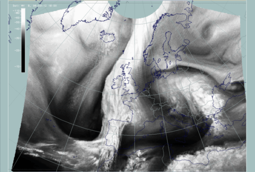
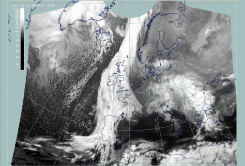
12 March 1996/18.00 UTC - Meteosat WV image
|
12 March 1996/18.00 UTC - Meteosat IR image
|
|
|
|
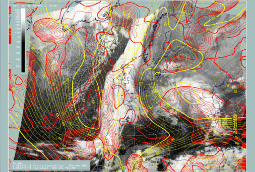
12 March 1996/18.00 UTC - Meteosat IR image; yellow: isotachs 300 hPa, red: positive vorticity advection (PVA) 300 hPa
|
|
|
|
|
|
|
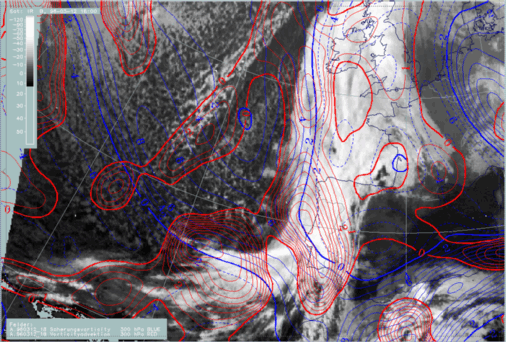
12 March 1996/18.00 UTC - Meteosat IR image; red: positive vorticity advection (PVA) 300 hPa, blue: shear vorticity 300 hPa
|
12 March 1996/18.00 UTC - Meteosat IR image; red: positive vorticity advection (PVA) 300 hPa, brown: curvature vorticity 300 hPa
|
The images containing shear and curvature vorticity can give an explanation for the last statement. As already suggested for the situation at 12.00 UTC, a change has taken place in the synoptic situation. The main features are the increase of the upper level trough in the area of the "Jet Intensification" (brown lines, right image) and the increase of a secondary jet streak at the boundary of the Wave bulge (blue lines, left image).
Summarising this special investigation, several points could be shown:
- The separation of conceptual models which have PVA as a key parameter with the use of curvature and shear vorticity; in this case a "Wave area" could clearly be distinguished from a "Front Intensification area by Jet Crossing".
- The detection of model errors concerning the location of jet streaks and jet axis with the help of the WV image.
- The detection and evaluation of changes in the synoptic situation, for instance by the deepening of a trough. There are two effects of this process on
the cloudiness:
- The cloud fibres typically at the jet axis of a jet streak become a cyclonically curved shape and finally dissolve
- Cyclogenesis in the wave area does not develop but stagnates. Consequently, the cloud bulge of the Wave remains and develops more distinct cloud edges but no spiral structure appears.

