12 MARCH 1996 - INTRODUCTION AND SHORT CASE DESCRIPTION
by ZAMG
12 March 1996/06.00 UTC - Meteosat IR image; SatRep overlay: names of conceptual models
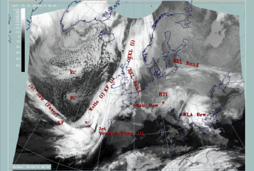
- There is a bulge in the cloudiness south-west of Ireland (around 49N/15W) which may be indicative of a Wave ("Welle") centred immediately south of it.
- A very intensive feature is a narrow fibrous cloud band along 40N crossing the frontal cloud band almost perpendicularly; such a structure is indicative of a jet streak ("Jet Bew (Faser)") (compare Conceptual Models: Jet Cloudiness (Fibre) ).
- Cellular textured cloudiness within the Cold Front cloud band can be noticed immediately south of the Wave where the cloud fibre crosses the Cold Front band. Such a situation would be typical for an intensification of the frontal system by means of a jet streak crossing ("Jet Verstaerkung") (compare Conceptual Models: Front Intensification by Jet Crossing ).
- There is a cloud band structure with much warmer cloud tops, situated on the leading edge of the main cloud band. It reaches from south-east England south-eastwards into France and western Germany where it is connected with a spirally structured cloud system representing an upper level low (the band feature discussed here is named "BKL Rand") (compare Conceptual Models: Baroclinic Boundary ).
In the cold air over the Atlantic behind the Cold Front, intensive cellular cloudiness can be noticed with some areas of Enhanced Cumuli, especially around 52N/27W, and another one with much warmer tops around 46N/24W ("EC").
In this part of the study the Cold Front as a whole, the cloud band connected to the Upper Level Low and the Enhanced Cumuli are discussed, while the Wave and the intensification by a "jet streak crossing" will be discussed in the special investigation of this case study.
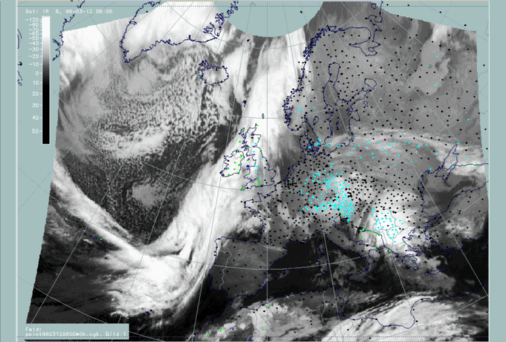
12 March 1996/06.00 UTC - Meteosat IR image; weather events (green: rain and showers, blue: drizzle, cyan: snow, purple:
freezing rain, red: thunderstorm with precipitation, orange: hail, black: no actual precipitation or thunderstorm with
precipitation)