09 - 10 APRIL 1996 - WAVE
by ZAMG
| abs.Top1000 + PVA500>=2 + TA>=0: | This parameter combination contains the relevant parameters for a Wave: the height contours at ground level (abs.Top 1000) (gpm) which show a low upstream of the cloud bulge, the field of PVA at 500 hPa greater than 2 units (* 10-9sec-2) which contains a maximum downstream of the cloud bulge indicating the deepening of the trough, and the field of warm advection 500/1000 hPa (TA>=0) (K 12h-1) which shows a maximum of warm advection within the area of the cloud bulge |
|---|---|
| PV: | This parameter is the isentropic potential vorticity (PV); the PV is automatically calculated every day in steps of 5° on the isentropic surfaces between Theta = 280K and Theta = 330K |
| TA=>0: | This key parameter shows, as described in the combination above, the thermal situation in the area of the Cold Front |
| VQS: | The cross section gives a better understanding of the vertical construction of the different meteorological systems; with this parameter the forecaster can locate calculated cross sections (VQS) |
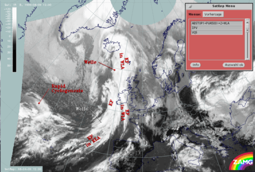
The satellite image contains two frontal mesoscale features in the form of a Wave:
- Within the cloud band of the classical Cold Front and the Cold Front in Cold Advection above the Atlantic south-west of Ireland at approximately 52N/12W
- Within the cloud band of the Cold Front in Warm Advection above the Atlantic north-west of Ireland at approximately 59N/13W
The southern Wave (which separates the classical Cold Front from the Cold Front in Cold Advection) is within the beginning stage of development. In the satellite image this Wave is not characterized by a pronounced cloud bulge. The field of the height contours at ground level show a pronounced trough within the area of the developing cloud bulge. Upstream of this trough a maximum of PVA at 500 hPa can be found. This maximum is connected with a slight trough at 500 hPa situated upstream of the main trough axis (compare chapter Cold Front ). Compared with an ideal distribution of PVA this maximum is situated a little bit too far downstream of the developing cloud bulge (for more information compare also Conceptual Models: Wave ). The temperature advection is characterized by weak warm advection north-east to east of the Wave. Occasionally strong cold advection can be found within the frontal cloud band situated upstream (compare chapter Cold Front in Cold Advection ). This distribution of temperature advection can often be observed and indicates that very cold air masses are transported within the circulation of the deepening low. The fact that there are some differences from the typical distribution of the key parameters (maximum of WA within the cloud bulge) can be explained by the fact that the Wave is within the beginning stage.
Although the distribution of the key parameters is not correctly analyzed by the model for a Wave, the forecaster's knowledge of the conceptual model of the Wave can identify that this is, or will be, an area for a developing Wave. The further development of this Wave for the next 12 hours will be discussed in more detail within the second part of this case study (compare also the second part of this case study Conceptual Models - Forecast for 09 April 1996/12.00 UTC and 18.00 UTC).
Looking at the northern Wave (within the Cold Front in Warm Advection) the satellite image shows a cloud bulge above the Atlantic at approximately 59N/13W. In contrast to the southern Wave the model shows only a slight trough. The axis of the trough can be found at approximately 58N. There are two PVA maxima upstream of the Wave. Both maxima, as computed by the model from a well-analyzed Wave, are shifted too far to the south. A weak maximum lies above western Ireland and a pronounced one lies within the area of the Cold Front. While the stronger maximum belongs to the Cold Front and indicates the deepening of the trough (compare chapter Cold Front ), the second weaker maximum is situated at the rear side of the Cold Front in Warm Advection. This second weaker maximum corresponds with the PVA maximum of the Wave. The third parameter is the field of temperature advection which shows warm advection within the cloud bulge as well as within the Cold Front situated upstream. Only above the Atlantic north-west of Ireland can a slight tendency for a classical distribution be found. Within this area the zero line of temperature advection shows a trough with weak cold advection. The reason for the deviation from the classical distribution (for more information compare also Conceptual Models: Wave ) is caused by the frontal system situated immediately behind (compare Cold Front and Cold Front in Cold Advection ).


