09 - 10 APRIL 1996 - RAPID CYCLOGENESIS
by ZAMG
09 April 1996/12.00 UTC - Meteosat IR image; SatRep overlay: names of conceptual models, SatRep menu: key parameters for Rapid Cyclogenesis
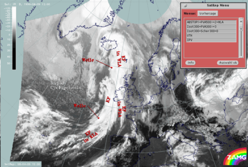
| abs.Top1000 + PVA500>=2 + TA>=0:
|
This parameter combination contains the relevant parameters for Rapid Cyclogenesis: the height contours at ground level (abs.Top 1000) (gpm)
which show a low upstream of the cloud head, the field of PVA at 500 hPa greater than 2 units (*10-9 sec-2) which contains a
maximum within the cloud head indicating the left exit region of a superimposed jet streak, and the field of warm advection 500/1000 hPa (TA>=0)
(K 12h-1) which shows a maximum of warm advection within the area of the cloud head
|
| Isot300 + PVA300>=3:
|
This combination contains the isotachs at 300 hPa greater than 30 units (m sec-1) and the field of PVA at 300 hPa greater than 3
units (*10-9sec-2) indicating the left exit region of a jet streak
|
| Isot300 + Scher300=0:
|
This combination contains the isotachs at 500 hPa greater than 30 units (m sec-1) and the zero line of the shear vorticity at 300 hPa
(Scher300=0) indicating the jet axis
|
| PV:
|
This parameter is the isentropic potential vorticity (PV) (*10-6m2 sec-1K kg-1); the PV is
calculated automatically every day in steps of 5° on the isentropic surfaces between Theta = 280K and Theta = 330K
|
| UTH:
|
The upper tropospheric humidity (UTH) (%) contains the humidity within the upper levels of the troposphere
|
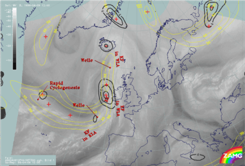
The cloud head of the Rapid Cyclogenesis is situated above the Atlantic north-west of the Azores at approximately 45N/35W.
09 April 1996/12.00 UTC - Meteosat IR image; magenta: height contours 1000 hPa, green: positive vorticity advection (PVA) 500 hPa, red: temperature
advection - WA 1000 hPa; SatRep overlay: names of conceptual models
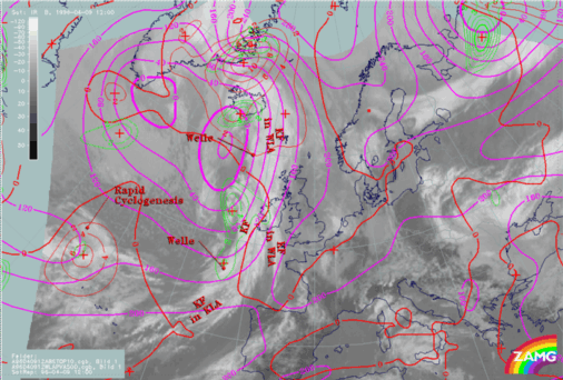
The absolute topography height contours at 1000 hPa, as well as the temperature advection and the field of positive vorticity advection at 500 hPa, show within the area of the rapid cyclogenesis a classical distribution of the key parameters (for more information compare also
Conceptual Models: Rapid Cyclogenesis
). Therefore a low can be found within the cloudless area of the
dry tongue between the cloudiness of the Cold Front and the cloud head. Furthermore there
is a pronounced area of warm advection within the cloud head and the frontal cloud band. The maximum of warm advection can be found at the transition zone between cloud head and frontal cloud band (at approximately 42N/33W). The field of vorticity advection shows, like the field of temperature advection, a maximum of PVA at 500 hPa within the area of the transition zone between the cloud head and the frontal cloud band of the Cold Front. In contrast to other investigated Rapid Cyclogenesis cases, where strong PVA maxima can be found, this one is only very weak. The absence of a definite PVA maximum is one of the indications (see also following paragraphs) that no further development will take place.
09 April 1996/12.00 UTC - Meteosat WV image; black: positive vorticity advection (PVA) 300 hPa, yellow: isotachs 300 hPa
The WV imagery is characterized by two black stripes within the area of the cloud head. The transition zone from white (moist air) to black (dry air) is a good indication for the location of the jet axis at approximately 300 hPa. The satellite image shows a jet axis along the poleward side of the cloud head which runs downstream along the rearward side of the frontal cloud band. A second much weaker transition zone can be found upstream of the merging zone between cloud head and frontal cloud band at approximately 43N/36W. The superimposed isotachs at 300 hPa confirm this interpretation of the WV imagery. Due to the large distance of the gridpoints of the model (about 150 km), the numerically computed isotachs show a broad zone extending within and at the poleward side of the cloud head. The only indication by the model that there are two jet streaks are the bulges of the isotachs within the areas of the entrance region (at approximately 44N/41W and 47N/35W).
Like the PVA at 500 hPa, the field of PVA at 300 hPa is also characterized by a very weak maximum within the area of the cloud head. This maximum may be attached to the right entrance region of the northern jet streak. It can often be observed that the cloud head indicating Rapid Cyclogenesis and which is also accompanied by severe weather events (like for instance thunderstorms, rain showers or gusty winds) is within the left exit region of the southern jet streak (for more information compare also
Conceptual Models: Rapid Cyclogenesis
). The fact that this cloud head cannot be found within the left exit region of a jet streak (pronounced maximum of PVA at 500 as well as at 300 hPa) is another indication for no further development.
|
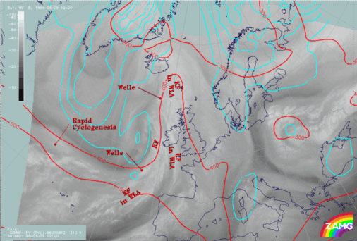
09 April 1996/12.00 UTC - Meteosat WV image; cyan: potential vorticity 310K, red: isobars; SatRep overlay: names of conceptual models
|
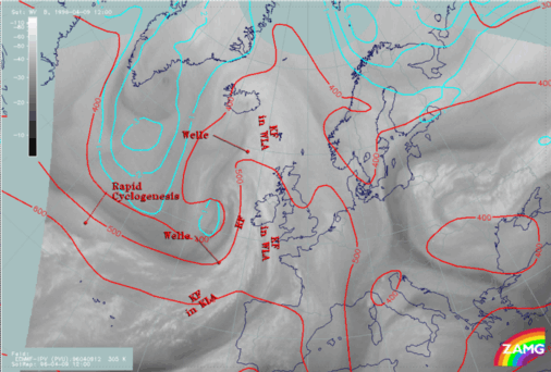
09 April 1996/12.00 UTC - Meteosat WV image; cyan: potential vorticity 305K, red: isobars
|
|
|
|
The two figures above include the potential vorticity on isentropic surfaces. Investigations have shown that the potential vorticity is a good indicator for whether the cloud head develops within its maturing stage through a
cyclone-like cloud spiral, or dissolves after a couple of hours (for more information compare also
Conceptual Models: Rapid Cyclogenesis
). On the higher isentropic surface (Theta = 310K) as well as on the lower isentropic surface (Theta = 305K) no anomaly of the potential vorticity (values between 1 and 2 *10
-6m
2K sec
-1kg
-1) can be observed within the area of Rapid Cyclogenesis. At both heights the anomaly can be found displaced far to the north of the cloud head. In the case of cloud heads where, during the maturing stage a cloud spiral develops, the anomaly often can be observed down to approximately 400 to 550 hPa. Due to the missing anomaly of the potential vorticity, no development of the cloud head to a
cyclone-like cloud spiral can be expected. The cloudiness of the Rapid Cyclogenesis should dissolve after a couple of hours (compare also the fourth part of this case study
"Special Investigation": Rapid Cyclogenesis).