09 - 10 APRIL 1996 - FORECAST FOR COLD FRONT
by ZAMG
|
09 April 1996/18.00 UTC - Meteosat IR image; weather events (green: rain and showers, blue: drizzle, cyan: snow, purple: freezing rain, red:
thunderstorm with precipitation, orange: hail, black: no actual precipitation or thunderstorm with precipitation)
|
10 April 1996/00.00 UTC - Meteosat IR image; weather events (green: rain and showers, blue: drizzle, cyan: snow, purple: freezing rain, red:
thunderstorm with precipitation, orange: hail, black: no actual precipitation or thunderstorm with precipitation)
|
|
|
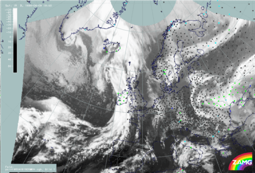
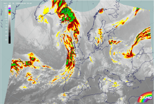
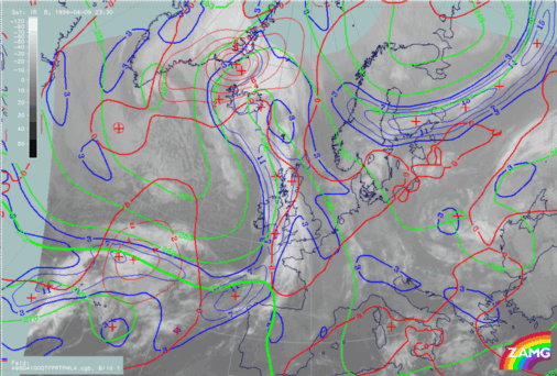
At 00.00 UTC the Cold Front can be found in the satellite image (right image) extending from the Atlantic north-west of the Iberian Peninsula, over the British Isles to Iceland. The Wave is situated above Ireland (compare Forecast for Wave ). As at 18.00 UTC, major parts of the frontal cloudiness are situated above the Atlantic. The synoptic stations situated within the cloud band report drizzle (blue crosses), rain and showers (green crosses).
|
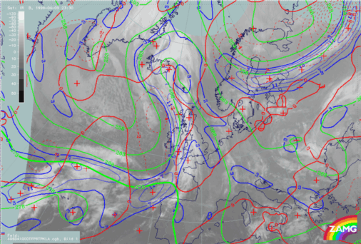
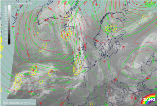
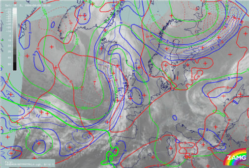
09 April 1996/18.00 UTC - Meteosat IR image; red: height contours 1000 hPa, green: height contours 500 hPa, yellow: positive vorticity advection
(PVA) 500 hPa
|
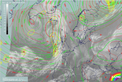
10 April 1996/00.00 UTC - Meteosat IR image; red: height contours 1000 hPa, green: height contours 500 hPa, yellow: positive vorticity advection
(PVA) 500 hPa
|
|
|
The third parameter which is superimposed on the image is the field of PVA at 500 hPa greater than 2 units. At 18.00 UTC (left image above) the northern part of the Cold Front and the area of the Wave is characterized by pronounced values of PVA. The field of PVA contains two maxima - a weaker maximum at the rear Cold Frontal cloud edge at approximately 58N/15W and a strong maximum within the area of the Wave which will be described in more detail within the sub-chapter Forecast for Wave . These pronounced values of PVA are a characteristic indication of an approaching or a deepening trough.
The right image above includes the absolute topography height contours at 1000 and 500 hPa at 00.00 UTC. At both heights a pronounced trough can be observed behind the Cold Front. Compared with the left image (18.00 UTC), a deepening of the trough within the last six hours can be observed. This deepening was already indicated by the pronounced values of PVA at 18.00 UTC (see also the paragraph above).
|
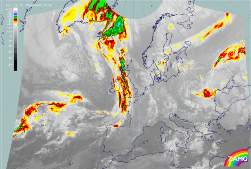
09 April 1996/18.00 UTC - Meteosat IR enhanced image
|
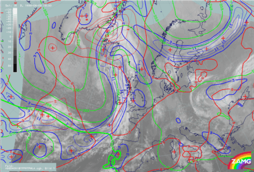
09 April 1996/18.00 UTC - Meteosat IR image; blue: thermal front parameter (TFP) 500/850 hPa, green: equivalent thickness 500/850 hPa, red:
temperature advection - WA 1000 hPa
|
|
|
|
|
|
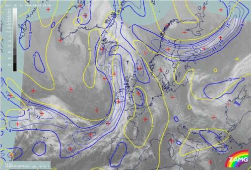
09 April 1996/18.00 UTC - Meteosat IR image; blue: thermal front parameter (TFP) 500/850 hPa, yellow: shear vorticity 300 hPa
|
Looking at the thermal conditions at 18 UTC (right image top), the crowding zone of equivalent thickness can be found within the frontal cloud band of the Cold Front. As a consequence of the position of the crowding zone, the maximum values of the TFP can be found within the leading part of the frontal cloudiness. The third superimposed parameter is the field of temperature advection (warm advection). Typical for an Ana Cold Front, the frontal cloud band is within cold advection. The zero line of temperature advection can be found along the leading cloud edge. Another key parameter combination constitutes the next image (left image bottom): the TFP and the zero line of shear vorticity at 300 hPa. Like the parameter combination described above, this image confirms the fact that the Cold Front is of the Ana Cold Front type. In the case of an Ana Cold Front the zero line of the shear vorticity at 300 hPa (indicating the jet axis) is parallel to the rear edge of the frontal cloud band. The meteorological background of this distribution is that at higher levels on the cyclonic side of the jet the dry relative stream of the dry intrusion is parallel to the rear frontal cloud band. The result of this process is that only moist air is transported through the Cold Front cloudiness on the anticyclonic side of the jet. Therefore no cloud dissolution will take place, which leads to the typical split front character within the image of a Kata Cold Front (for more information compare also Conceptual Models: Cold Front and Conceptual Models: Split Front ).
|
10 April 1996/00.00 UTC - Meteosat IR enhanced image
|
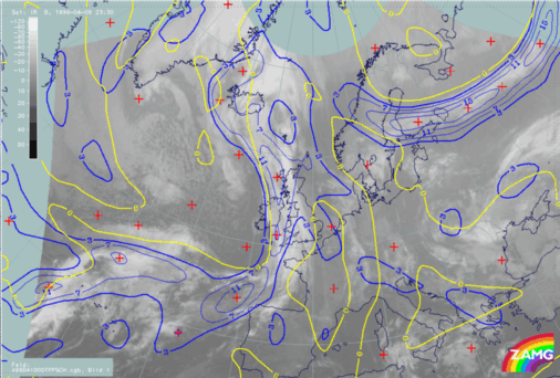
10 April 1996/00.00 UTC - Meteosat IR image; blue: thermal front parameter (TFP) 500/850 hPa, green: equivalent thickness 500/850 hPa, red:
temperature advection - WA 1000 hPa
|
|
|
|
|
|
10 April 1996/00.00 UTC - Meteosat IR image; blue: thermal front parameter (TFP) 500/850 hPa, yellow: shear vorticity 300 hPa
|
In comparison with the image from 18.00 UTC, the key parameters at 00.00 UTC look very similar. The crowding zone of the equivalent thickness (right image top) and the maximum values of the TFP can be found within the leading part of the frontal cloud band. The northern part of the Cold Front is within cold advection. The zero line of the temperature advection is situated very close to the leading cloud edge. The second parameter combination contains the TFP and the zero line of the shear vorticity at 300 hPa (left image bottom). Like the image six hours before, the zero line can be found parallel to the rear cloud edge of the Cold Front.