09 - 10 APRIL 1996 - COLD FRONT IN COLD ADVECTION
by ZAMG
| Front Indicator: | The front indicator indicates the maximum values of the thermal front parameter (TFP) 500/850 hPa (*10-1Km-1) which is an indication for the surface front |
|---|---|
| TFP + rel.Top + TA<=0: | This combination contains the thermal front parameter (TFP) 500/850 hPa greater than 3 units, the equivalent thickness (rel.Top) 500/850 hPa (K) and cold advection 500/1000 hPa (TA<=0) (K 12h-1); this parameter combination contains the information about the thermal situation in the area of the Cold Front |
| TA=<0: | This key parameter shows, as described in the combination above, the thermal situation in the area of the Cold Front |
| PVA500>=2: | This field shows areas of positive vorticity advection (PVA) at 500 hPa greater than 2 units (*10-9 sec-2); this parameter is an indicator of upward motion and therefore describes possible areas of increased weather events (compare also the chapters within the manual Conceptual Models: Wave , Conceptual Models: Rapid Cyclogenesis and Conceptual Models: Front Intensification by Jet Crossing ) |
| Relative Stroeme: | The relative streams show the flow of the relative wind field; this point of view gives more detailed information about the different air masses (like for instance their origin or areas with sinking or rising motion) which are involved in the corresponding meteorological system; in contrast to the parameters described above, which are analyzed on isobaric surfaces, the relative streams show the situation on isentropic surfaces |
| VQS: | The cross section gives a better understanding of the vertical construction of the different meteorological systems; with this parameter the forecaster can locate calculated cross sections (VQS) |
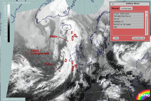
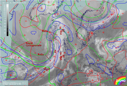
The cloud band of this Cold Front extends from the Atlantic east of the Azores to approximately 47N/13W. The cloud band of the Cold Front in Cold Advection is separated from the cloud band of the classical Cold Front by a Wave. This mesoscale feature will be described in more detail within the sub-chapter Wave .
Like the classical Cold Front (compare sub-chapter Cold Front ) the crowding zone of the equivalent thickness can be found behind the Cold Front cloud band. The TFP has its maximum values, representing the surface Cold Front, within the rear part of the cloud band.
The further development of the cold front in cold advection for the next 12 hours can be found within the second part of this case study (compare also the second part of this case study Conceptual Models - Forecast for 09 April 1996/12.00 UTC and 18.00 UTC).


