09 - 10 APRIL 1996 - COLD FRONT
by ZAMG
| Front Indicator: | The front indicator indicates the maximum values of the thermal front parameter (TFP) 500/850 hPa (*10-1Km-1) which is an indication for the surface front |
|---|---|
| TFP + rel.Top + TA>=0: | This combination contains the thermal front parameter (TFP) 500/850 hPa greater than 3 units, the equivalent thickness (rel.Top) 500/850 hPa (K) and warm advection 500/1000 hPa (TA>=0) (K 12h-1); this parameter combination contains the information about the thermal situation in the area of the Cold Front |
| TFP + Scher300=0: | This combination contains the TFP and the zero line of shear vorticity at 300 hPa (Scher300=0) and is indicative of the relation between front and jet stream; with the help of this combination it is also possible to identify whether the Cold Front is from the Ana or the Kata Cold Front type |
| abs.Top500 + abs.Top1000: | This key parameter combination shows the geopotential height at 500 hPa (abs.Top500) (gpm) as well as at 1000 hPa (abs.Top1000) (gpm), both parameters show the pressure distribution within the mid-levels of the troposphere (abs.Top500) and on the surface (abs.Top1000) |
| PVA500>=2: | This field shows areas of positive vorticity advection (PVA) at 500 hPa greater than 2 units (*10-9sec-2); this parameter is an indicator of upward motion and therefore describes possible areas of increased weather events (compare also Conceptual Models: Wave , Conceptual Models: Rapid Cyclogenesis and Conceptual Models: Front Intensification by Jet Crossing ) |
| Relative Stroeme: | The relative streams show the flow of the relative wind field; this point of view gives more detailed information about the different air masses (like for instance their origin or areas with sinking or rising motion) which are involved within the corresponding meteorological system; in contrast to the parameters described above which are analyzed on isobaric surfaces, the relative streams show the situation on isentropic surfaces |
| VQS: | The cross section gives a better understanding of the vertical construction of the different meteorological systems; with this parameter the forecaster can locatecalculated cross sections (VQS) |
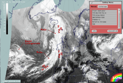
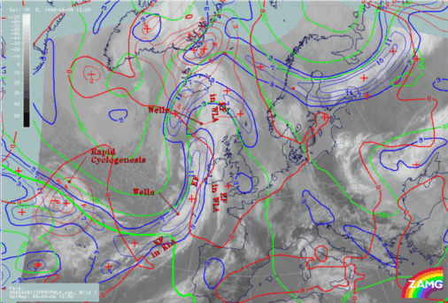
The cloud band of the "classical" Cold Front extends over the Atlantic from approximately 49N/12W to approximately 57N/16W. The cloud band of the Cold Front is separated from the southern part of the cloud band (Cold Front in Cold Advection) by a Wave. This mesoscale feature will be described in more detail within the sub-chapter Wave .
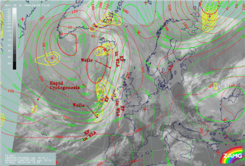
The third parameter which is superimposed on the image is the field of PVA at 500 hPa. This shows high values along the rear edge of the frontal cloud band. These pronounced values of PVA are an indication for the deepening of the trough. Areas of PVA maxima, superimposed on the frontal cloudiness, are due to regions with increased upward motion where severe weather events can preferentially occur (thunderstorms and heavy rain showers).
The further development of the Cold Front for the next 12 hours can be found within the second part of this case study (compare also the second part of this case study Conceptual Models - Forecast for 09 April 1996/12.00 UTC and 18.00 UTC).


