Jet Fibres - Meteorological Physical Background
by DHMZ
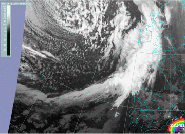
In general, bands of cirrus clouds tend to form or persist on the anticyclonic side of the jet. The reason for this is that jet streams are associated with the strong thermal contrast across frontal zones and the layered clouds form in the warm moist air of the Warm Conveyor Belt with cloud edge lying along the jet core.
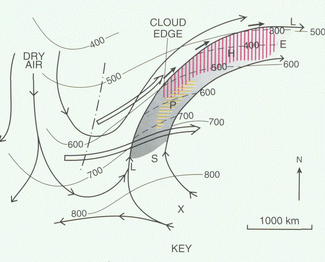
About 50 cases were examined in this investigation. It has been observed that Jet Fibres are mostly found over the Warm Front Shield or behind a Cold Front.
There is no single theory explaining the formation of the Jet Fibres, but there are several mechanisms probably acting in combination.
Generally, there are two necessary conditions needed for clouds to develop: sufficient humidity content and upward motion.
As already mentioned one of the large-scale mechanisms causing upward motion is a Warm Conveyor Belt, bringing warm and humid air to upper levels (see Warm Front Shield - Meteorological Physical Background ). The other one, in case of the Fibres connected to a Cold Front, would be slantwise ascent of the air above the slope of the Cold Front (see Cold Front - Meteorological Physical Background ).
This synoptic scale upward motion would bring a lot of humid air to upper levels and form a broad band of clouds (frontal clouds or broad cirrus bands). So, in order to produce a cloud structure of relatively small dimensions, such as Jet Fibres, there must be an additional smaller scale mechanism.
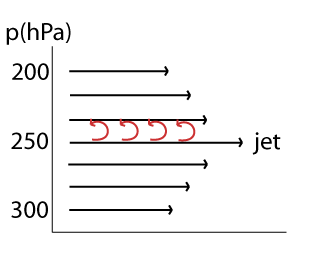
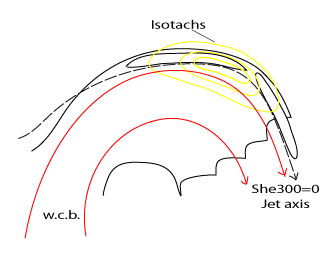
Since a jet is necessarily involved in the formation of Jet Fibres, ascent may also occur because of the circulation in the cells around the entrance and the exit regions of the jet streak.

Taking into account the vertical wind shear, directly above the jet core there is also upward motion on a smaller (turbulence) scale.
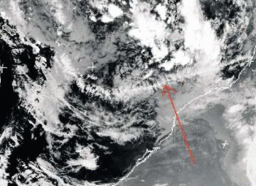
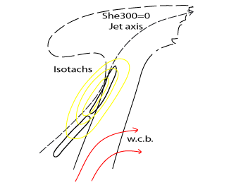
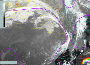
In some special cases, a Jet Fibre can get an interesting ornament. Namely, ribbons of cirrus, perpendicular to the Jet Fibre (image beneath), may be seen. This phenomenon occurs in the synoptic environment of an upper level trough and is usually associated with a cold front. The deep frontal cloud dissolves, but cirrus ribbons may persist for days if wind speeds in a subtropical jet are not exceeding 40 m/s and there is a large horizontal wind shear.
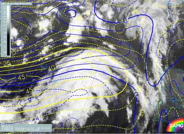
Jet Fibres behind the Cold Front
In the case of the Cold Front, besides the large scale ascending motion there is the impact of the upward motion in the right entrance region of the jet streak and small-scale upward motion caused by wind shear. Therefore, fibres form to the rear of the frontal cloud band, parallel to the jet axis, adjacent to or in the right entrance region of the jet streak, usually on the anticyclonic side of the jet.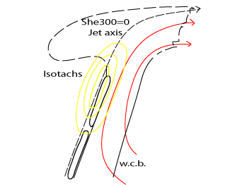
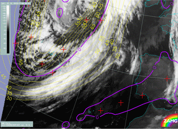
Besides the cases when Jet Fibres form parallel to the frontal zone, there are also numerous cases in which jet stream comes from behind the front at a certain angle. This is typically the case when the Cold Front is Kata type. In that case fibres are also located along the jet axis or slightly on the anticyclonic side.
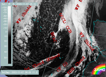
Jet fibres on top of the Warm Front Shield
The upward motion within a Warm Front is associated with the rising Warm Conveyor Belt with the limiting streamline on the jet axis. If the air mass in the warm conveyor belt (or a similar relative stream) is very humid, a broader band of high cloud fibres develops (see Warm Front Shield and Warm Conveyor Belt ).Besides the smaller scale mechanisms responsible for the formation of Jet Fibres already mentioned in the case of the Cold Front, there is also an influence of the sharply curving jet stream. When the jet is curved, shear caused by the change of the wind speed is increased by the shear resulting from the change in wind direction.
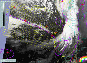
Fibres also form on the cyclonic side of the Warm Front within the frontal cloud band, and there are numerous cases when the jet extends the Fibres beyond the cloud band.
Discussion
Although theory states that the jet flows around the Warm Front cloud band and that the fibres should therefore develop above the frontal cloud band, on the anticyclonic side of the jet, there are numerous cases in which the situation is quite different. Namely, the jet flows through the Warm Front cloud band, fibres are still along the edge of the Warm Front cloud band, but on the cyclonic side of the jet. Here is one such case: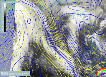
There are several possible explanations but the most probable one is that this effect is a result of the combination of the following causes:
- The model is not perfectly reliable: parameter fields can be shifted, especially the forecast parameters.
- The Jet axis is tilted vertically: at higher levels the jet is inclined more northwards compared to its location in lower levels, looking in the direction of the jet. Therefore, if the strongest winds are at level higher than 300 hPa (which is often the highest level in the global model or at least the one representing the jet stream) it is possible that the position of the fibre is determined by a higher jet axis. In that case, the jet axis at 300 hPa would be located more southward and could therefore appear to be on the anticyclonic side of the Jet Fibre.
- The circulation around the jet axis: small-scale circulation makes the air rise on the anticyclonic and sink on the cyclonic side. Therefore, there is necessarily also part of that circulation cell which transports the air from anticyclonic to cyclonic side at upper layers. Taking into account that air cannot dry instantly, it is possible that humid air also persists for some time on the cyclonic side of the jet.
- Sharply curving jet axis: Because of the shear caused by curvature, there could also be some ascent on the cyclonic side of the jet allowing the cirrus to persist on that side.


