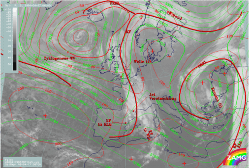
17 APRIL 1996 - CYCLOGENESIS IN THE WESTERN MEDITERRANEAN: DIAGNOSIS FOR 17 APRIL 06.00 UTC
by ZAMG
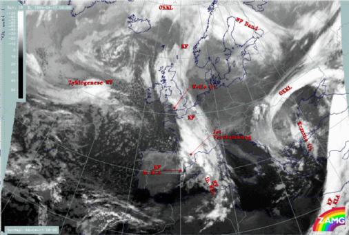
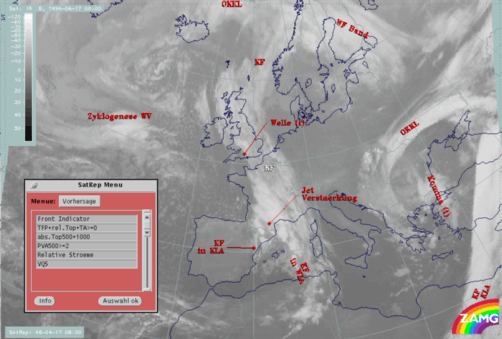
The diagnosis in the SatRep indicates three different conceptual models:
- A "Front Intensification by Jet Crossing", called "Jet Intensification" (compare Conceptual Models: Front Intensification by Jet Crossing ) in the area of enhanced cloudiness over south France and the Pyrenees
- A "Cold Front in Cold Advection" (compare Conceptual Models: Cold Front in Cold Advection ) for the short front-like branch south of the Pyrenees along the Spanish east coast
- A "Cold Front in Warm Advection" (compare manual, Conceptual Models: Cold Front in Warm Advection ) for the eastern branch in the western Mediterranean, from the French south coast to the North African coast.
This is a rather unusual diagnosis and has to be enhanced.
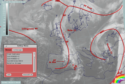
| Front Indicator: | This is a line indicating the maximum of the thermal front parameter (TFP) 500/850 hPa (*10-1K m-1) |
|---|---|
| Isot + PVA300>=3: | This is a combination of isotachs greater than 30 units (m sec-1) and positive vorticity advection (PVA) at 300 hPa greater than 3 units (*10-9sec-2) |
| Isot + PVA500>=2: | This is a combination of isotachs greater than 30 units (m sec-1) and positive vorticity advection (PVA) at 500 hPa greater than 2 units (*10-9sec-2); both parameter combinations locate the exit region and the PVA maximum in relation to the frontal cloud band |
| Isot300 + Scher300=0: | This parameter combination shows the isotachs greater than 30 units (m sec-1) and the zero line of shear vorticity which marks the jet axis; one can get information about the existence and strength of jet streaks and the course of the jet axis |
| Relative Stroeme (relative streams): | This parameter shows relative streams on isentropic surfaces; relative streams are indicative of the different air masses involved in the process and of areas of sinking or rising motion; they can be used for cloud configurations requiring special explanation |
|
17 April 1996/06.00 UTC - Meteosat IR image; ECMWF forecast fields; black: positive vorticity advection (PVA) 500 hPa, yellow: isotachs 500 hPa;
SatRep overlay: names of conceptual models
|
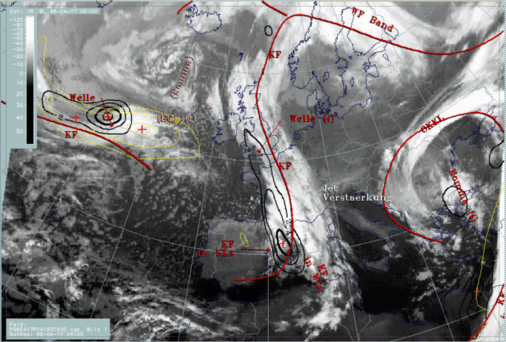
17 April 1996/06.00 UTC - Meteosat IR image; ECMWF forecast fields; black: positive vorticity advection (PVA) 300 hPa, yellow: isotachs 300 hPa;
SatRep overlay: names of conceptual models
|
|
|
|
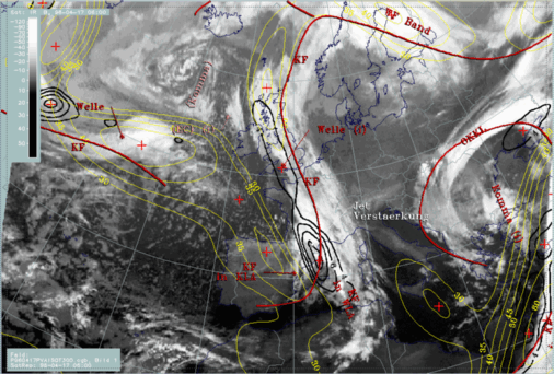
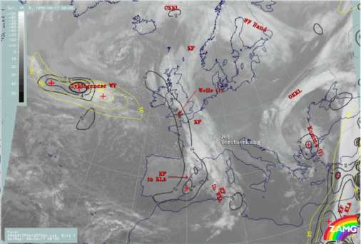
17 April 1996/06.00 UTC - Meteosat IR image; ECMWF analysis data; black: positive vorticity advection (PVA) 500 hPa, yellow: isotachs 500 hPa;
SatRep overlay: names of conceptual models
|
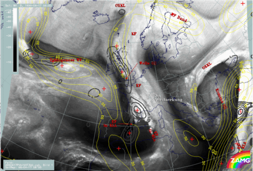
17 April 1996/06.00 UTC - Meteosat IR image; ECMWF analysis data; black: positive vorticity advection (PVA) 300 hPa, yellow: isotachs 300 hPa;
SatRep overlay: names of conceptual models
|
|
|
- There is no separate jet streak above the Iberian Peninsula, but only a southward oriented secondary branch belonging to the main jet streak over the Atlantic along 50N; there is no indication of a jet streak at 500 hPa at all. Nevertheless, at 300 hPa the PVA maximum fits to the left exit region and accompanies the intensified frontal cloud part over France.
- At both levels a second PVA maximum to the south of the one just discussed, which accompanies the short branch of the Cold Front over east Spain, can be seen. This PVA maximum has the same strength as the northern one and should, since it is not combined with a jet streak, be a consequence of a propagating trough. This strong PVA maximum may also play an important role in the formation of the short cloud band which will be discussed further below.
So, from the comparison of the relevant parameter fields computed from ECMWF forecasts and diagnoses, the conceptual model "Jet Intensification" is restricted to the northern part of the cloud intensification over France and the Pyrenees, while a clear indication of the development of frontal cloudiness south of it can be drawn at both height levels. This will be enlightened by the key parameters typical for Cold Fronts.
| Front Indicator: | This is a line indicating the maximum of the thermal front parameter (TFP) 500/850 hPa (*10-1K m-1) |
|---|---|
| TFP + rel.Top + TA>=0: | This combination contains the thermal front parameter (TFP) 500/850 hPa greater than 3 units, the equivalent thickness (rel.Top) 500/850 hPa (K) and warm advection 500/1000 hPa (TA>=0) (K 12h-1); this parameter combination contains the information about the thermal situation in the area of the Cold Front |
| TFP + Scher300=0: | This is a combination of the thermal front parameter (TFP) 500/850 hPa greater then 3 units and the zero line of shear vorticity at the 300 hPa level (Scher300=0); this combination of key parameters is indicative of the relation between front and jet stream |
| abs.Top500 + abs.Top1000: | This is the combination of height contours at 1000 and 500 hPa (gpm); this combination of key parameters is indicative of the stream and pressure distribution near the surface and in the middle of the troposphere |
| PVA500>=2: | This parameter shows maxima of positive vorticity advection (PVA) at 500 hPa exceeding 2 units (*10-9sec-2); this key parameter indicates areas with increased possibility of more severe weather events because of increased vertical motion (compare manual Conceptual Models: Wave and Conceptual Models: Front Intensification by Jet Crossing ) |
| Relative Stroeme (relative streams): | This parameter shows relative streams on isentropic surfaces; relative streams are indicative of the different air masses involved in the process of sinking or rising areas; they can be used to explain cloud configurations requiring special explanation |
| VQS: | Gives the location of available vertical cross sections (VQS) |
|
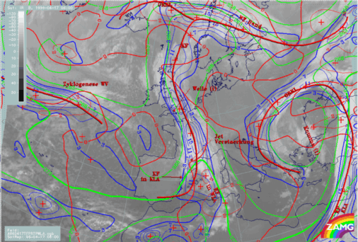
17 April 1996/06.00 UTC - Meteosat IR image; blue: thermal front parameter (TFP) 500/850 hPa, red thick: front indicator, green: equivalent
thickness 500/850 hPa, red: temperature advection - WA 1000 hPa; SatRep overlay: names of conceptual models
|
17 April 1996/06.00 UTC - Meteosat IR image; red thick: front indicator, red: height contours 1000 hPa, green: height contours 500 hPa; SatRep
overlay: names of conceptual models
|
|
|
The height contours at 1000 and 500 hPa reveal an atypical situation which may be the main reason for the untypical substructures. There is a low at the 1000 hPa surface exactly at the rear of the eastern cloud band, which is the one that shows features of a Warm Front in the thickness and temperature advection field. In contrast to this, there is a newly developed short Wave trough and ridge system at the 500 hPa level which leads to a distribution of a height ridge superimposed on the eastern cloud band, but a pronounced trough at the rear of the western cloud band. The latter is connected with the PVA maximum mentioned above in the paragraphs about "Jet Intensification".
|
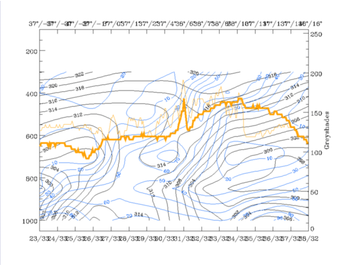
17 April 1996/06.00 UTC - Vertical cross section; black: isentropes (ThetaE), blue: relative humidity, orange thin: IR pixel values, orange
thick: WV pixel values
|
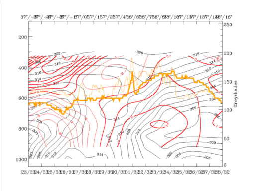
17 April 1996/06.00 UTC - Vertical cross section; black: isentropes (ThetaE), red thin: temperature advection - CA, red thick: temperature
advection - WA, orange thin: IR pixel values, orange thick: WV pixel values
|
|
|
|
|
|
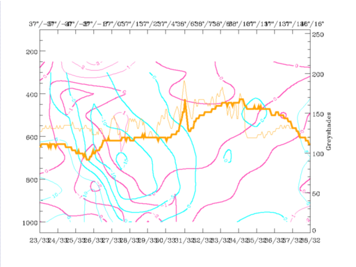
17 April 1996/06.00 UTC - Vertical cross section; black: isentropes (ThetaE), cyan thick: vertical motion (omega) - upward motion, cyan thin:
vertical motion (omega) - downward motion, magenta thin: divergence, magenta thick: convergence, orange thin: IR pixel values, orange thick: WV
pixel values
|
The short frontal cloud band along the Spanish east coast is accompanied by a configuration of isentropes that shows a very unstable area from the surface up to 600 hPa, with very dry air above 850 hPa and CA in a layer from the earth surface up to about 550 hPa. A zone of strong convergence accompanied by strong upward motion has much more the shape of a frontal zone than the configuration of equivalent potential temperature. From this distribution of parameters it seems to be clear that no thick cloud band can be expected, but rather some convective effects according to the existing instability. In addition to this it has to be remembered that this cloud band is connected with the small scale upper level trough and the PVA maximum in front of it.
The eastern frontal cloud band shows indeed a configuration of isentropes which is typical for a Warm Front accompanied by maximal WA. But it has to be remembered that there are serious doubts about this and that this cloud band is regarded rather as a modified cold front than as a Warm Front. In the vertical cross section, there are some smaller indications supporting this idea:
- There is a small upper level Cold Front between 400 and 500 hPa on top of the Warm Front zone (38N/06E - 38N/07E) which is accompanied by a pronounced maximum of CA. Such a configuration and intensity is unusual for Warm Fronts.
- The distribution of relative humidity shows only low values within the supposed Warm Front zone, but a narrow zone of high values of 60 - 70 % between 700 - 400 hPa, which has a distinct connection to the upper level Cold Front.
So, with help of the vertical cross sections some more details of the vertical distribution, especially concerning instability, can be derived. However, still the question about the kind of front type of the eastern cloud band cannot be clarified completely. It seems that there is a pronounced change in the complete state of the troposphere, mainly because of the development of the upper level trough which can be followed further in the forecast.


