17 APRIL 1996 - COLD FRONT
by ZAMG
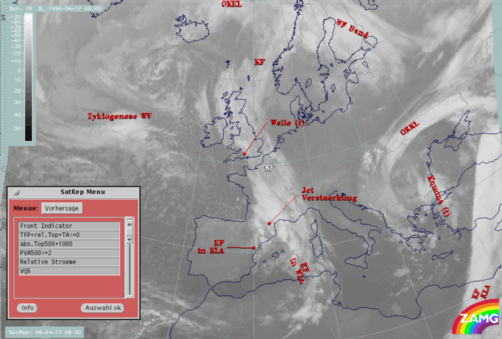
| Front Indicator: | This is a line indicating the maximum of the thermal front parameter (TFP) 500/850 hPa (*10-1K m-1) |
|---|---|
| TFP + rel.Top + TA>=0: | This combination contains the thermal front parameter (TFP) 500/850 hPa greater than 3 units, the equivalent thickness (rel.Top) 500/850 hPa (K) and warm advection 500/1000 hPa (TA>=0) (K 12h-1); this parameter combination contains the information about the thermal situation in the area of the Cold Front |
| TFP + Scher300=0: | This is a combination of the thermal front parameter (TFP) 500/850 hPa greater then 3 units and the zero line of shear vorticity at the 300 hPa level (Scher300=0); this combination of key parameters is indicative of the relation between front and jet stream |
| abs.Top500 + abs.Top1000: | This is the combination of height contours at 1000 and 500 hPa (gpm); this combination of key parameters is indicative of the stream and pressure distribution near the surface and in the middle of the troposphere |
| PVA500>=2: | This field shows areas of positive vorticity advection (PVA) at 500 hPa greater than 2 units (*10-9sec-2); this key parameter indicates areas with increased possibility for more severe weather events because of increased vertical motion (compare also Conceptual Models: Wave and Conceptual Models: Front Intensification by Jet Crossing ) |
| Relative Stroeme: | This parameter shows relative streams on isentropic surfaces; relative streams are indicative of the different air masses involved in the process of sinking or rising areas; they can be used to explain cloud configurations requiring special explanation |
| VQS: | Gives the location of available vertical cross sections (VQS) |
|
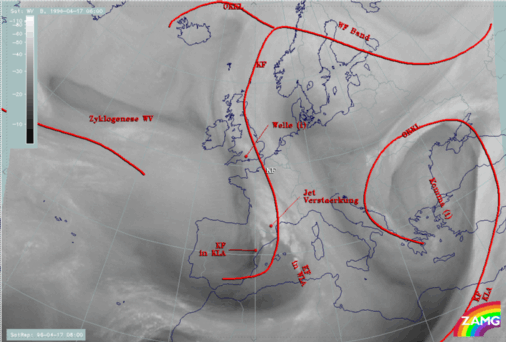
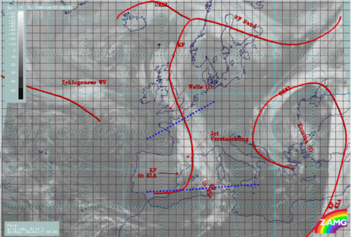
17 April 1996/06.00 UTC - Meteosat IR image; blue: thermal front parameter (TFP) 500/850 hPa, red thick: front indicator, green: equivalent
thickness 500/850 hPa, red: temperature advection - WA 1000 hPa; SatRep overlay: names of conceptual models
|
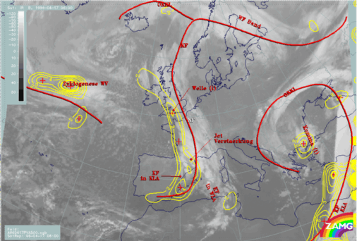
17 April 1996/06.00 UTC - Meteosat WV image; red thick: front indicator; SatRep overlay: names of conceptual models
|

|
|
Equivalent thickness (green) reveals that there is a trough at the rear of the cloud band which is very pronounced but does not show a broad zone of high gradients. Consequently, the change from warm air within the thickness ridge in front of the cloud band to the cold air in the thickness trough behind it is not so well developed in this kind of presentation. Although the zero line of temperature advection (TA) is very close to the frontal edge of the cloud band, there are no pronounced centres of WA and CA.
The situation in the Mediterranean differs from the one described just now with much more distinct gradients in the thickness and a well-developed area of WA. This will be discussed in the special investigation (compare "Special Investigation": Cyclogenesis in the Western Mediterranean Including Detection of Numerical Model Error).
In summary, the frontal cloud band is not accompanied by very distinct transitions of air masses in the layer under discussion (500/850 hPa); reasons for this may be that it is already an old system or that there are distinct differences in the single layers which are averaged in the whole layer. Vertical cross sections which are discussed further below can give an answer to these assumptions.
|
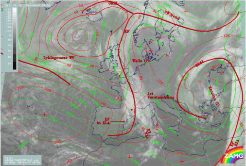
17 April 1996/06.00 UTC - Meteosat IR image; red: height contours 1000 hPa, green: height contours 500 hPa; SatRep overlay: names of conceptual
models
|
17 April 1996/06.00 UTC - Meteosat IR image; red thick: front indicator, yellow: positive vorticity advection (PVA) 500 hPa; SatRep overlay:
names of conceptual models
|
|
|
The yellow lines in the right image represent maxima of positive vorticity advection at 500 hPa (PVA) and accompany the rear side of the frontal cloud band with the main maximum over the Mediterranean part (compare"Special Investigation": Cyclogenesis in the Western Mediterranean Including Detection of Numerical Model Error) and a second maximum immediately south of the cloud bulge. The latter is typical for an ongoing Wave development (compare Wave or Conceptual Models: Wave ).
|
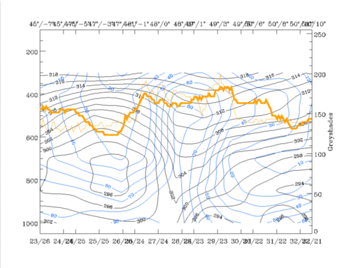
17 April 1996/06.00 UTC - Vertical cross section; black: isentropes (ThetaE), blue: relative humidity, orange thin: IR pixel values, orange
thick: WV pixel values
|
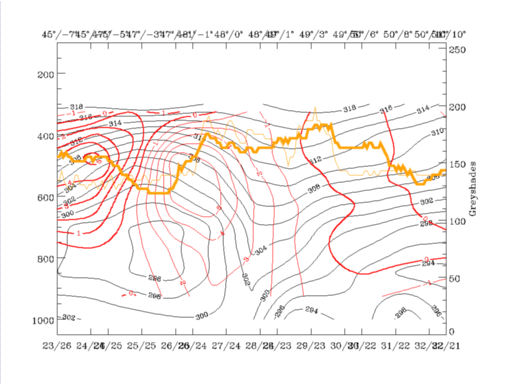
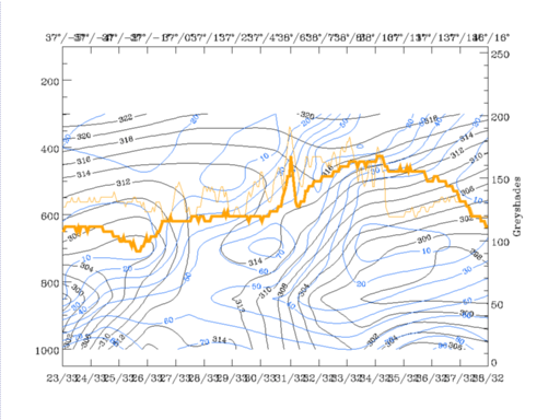
17 April 1996/06.00 UTC - Vertical cross section; black: isentropes (ThetaE), red thin: temperature advection - CA, red thick: temperature
advection - WA, orange thin: IR pixel values, orange thick: WV pixel values
|
|
|
However, there are a lot of reasons which contradict the diagnosis of an Occlusion cloud band:
- The left, Cold Front - like zone of high gradients of isentropes reaches deep down to the earth surface
- There is no warm advection (red in the right cross section) in the area where the isentropes are forming a trough.
Consequently, the conclusion would be that there is a Cold Front in an advanced stage of development, mostly under the influence of CA, with a broad cloud band mostly in front of the Cold Front zone characterized by the isentropes. This Cold Front zone is on top and in front of an unstable air mass centred around 47N/03W which is in the cold, cloud free air behind the frontal cloud band. Because of very dry and cold air which reaches from the top of the troposphere down to approximately 800 hPa no cloudiness develops. The WV imagery shows the dry air as a pronounced black stripe in the area of Brittany.
|
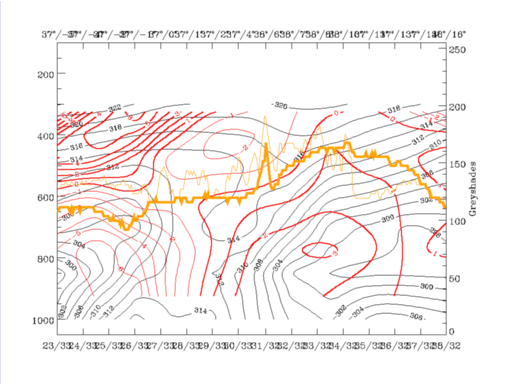
17 April 1996/06.00 UTC - Vertical cross section; black: isentropes (ThetaE), red thin: temperature advection - CA, red thick: temperature
advection - WA, orange thin: IR pixel values, orange thick: WV pixel values
|
17 April 1996/06.00 UTC - Vertical cross section; black: isentropes (ThetaE), blue: relative humidity, orange thin: IR pixel values, orange
thick: WV pixel values
|
|
|


