17 APRIL 1996 - WAVE
by ZAMG
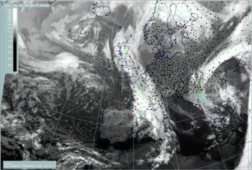
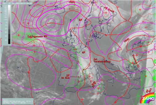
17 April 1996/06.00 UTC - Meteosat IR image; SatRep overlay: names of conceptual models, SatRep menu: key parameters for Wave
The cloud bulge at the rear side of a frontal cloud band which is characteristic of the conceptual model "Wave", indicating the possibility of secondary cyclogenesis, can be seen in this case over the British Isles. The marking of the conceptual model in the SatRep close to south England should
indicate the low centre, while the cloud bulge characterizes warm air being advected within low circulation (compare
Conceptual Models: Wave
).
For the diagnosis of the physical state of the conceptual model "Wave", a couple of key parameters and useful key parameter combinations are available which were chosen with respect to this model.
| ABSTOP1000 + PVA500>=2 + WLA:
|
This is a commonly used combination of three parameters typically indicative of a Wave:
- The height contour very close to the ground 1000 hPa (gpm) which in the case of a Wave shows a trough;
- PVA at 500 hPa greater than 2 units (*10-9sec-2 which in the case of a Wave contains a maximum
indicating the deepening of the low;
- WA 500/1000 hPa (K 12h-1) which, together with a maximum of CA at the rear of the Wave bulge, is another sign of
the circulation taking place in the Wave area and transporting warm and cold air in cyclonic directions.
|
| PV:
|
Represents isentropic potential vorticity (*10-6m2K sec-1kg-1) at several levels
|
| VQS:
|
Gives the location of available vertical cross sections (VQS)
|
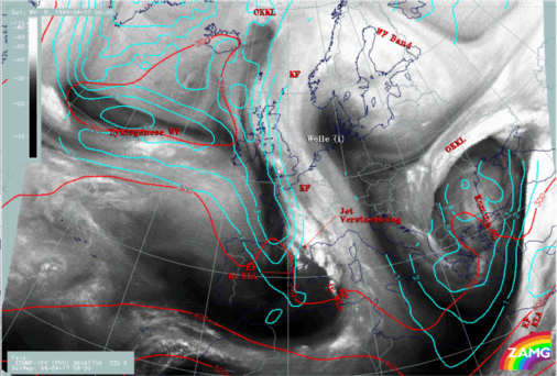
17 April 1996/06.00 UTC - Meteosat IR image; magenta: height contours 1000 hPa, red: temperature advection - WA 1000 hPa, green: positive vorticity
advection (PVA) 500 hPa; SatRep overlay: names of conceptual models
Two of the three selected key parameters fulfil the conditions of the conceptual model "Wave" quite well: there is a pronounced trough in the height field of 1000 hPa (magenta) with a minimum from central England to north France, and a maximum of PVA (green) over south England and the English Channel. The third parameter, TA, which should form a WA maximum within the cloud bulge next to a CA maximum in the cloud-free air, shows only a very weak WA area in front
of the cloud bulge.
So, the situation does not show perfect conditions for the key parameters usually used. Therefore, additional parameters are taken into account. These are for instance isentropic potential vorticity (compare
Conceptual Models: Wave - Meteorological physical background
) which, in a well developed situation, shows stratospheric air characterized by values higher than 2 PV units. If a Rapid Cyclogenesis takes place, stratospheric air reaches deep down to about 500 - 450 hPa, while for weak, slow cyclogenesis, stratospheric air can only be followed down to about 300 hPa.
|
17 April 1996/06.00 UTC - Meteosat IR image; weather events (green: rain and showers, blue: drizzle, cyan: snow, purple: freezing rain, red:
thunderstorm with precipitation, orange: hail, black: no actual precipitation or thunderstorm with precipitation)
|
|
|
|
|
|
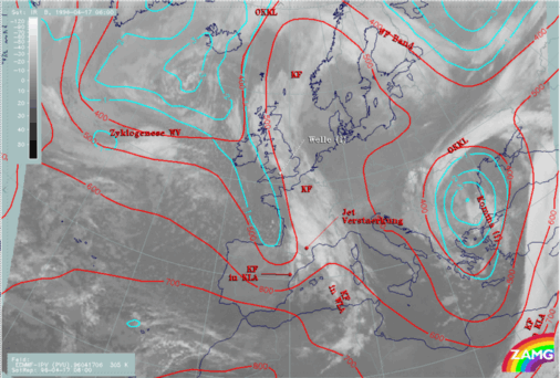
17 April 1996/06.00 UTC - Meteosat WV image; cyan: potential vorticity (PV) 320K, red: isobars; SatRep overlay: names of conceptual models
|
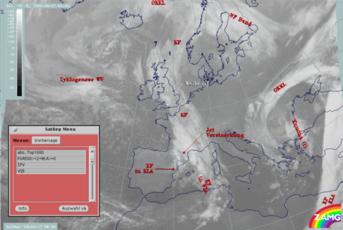
17 April 1996/06.00 UTC - Meteosat IR image; cyan: potential vorticity (PV) 305K, red: isobars; SatRep overlay: names of conceptual models
|
|
|
|
Two isentropic surfaces are chosen: 320K which is very high according to the vertical cross section in the upper panel, and 305K which is well situated within the frontal surface. Both images show a trough of PV isolines (cyan) on the rear side and parallel to the frontal cloud band from north-west of Scotland down to south France. On the higher isentropic surface (left image), stratospheric air with values higher than 3 units has reached height levels only around 300 hPa. But on the lower isentropic surface, PV values between 1 and 2 indicate the transition between tropospheric and stratospheric air in a height layer between 500 and 400 hPa which is rather low. This is in line with the vertical cross section (upper panel), where stratospheric air in an area around 47N/03W reaches down to about 600 hPa and is connected with low IR and WV pixel values.
From these results an integration of dry stratospheric air into the process of cyclogenesis cannot be excluded, and supports the diagnosis of the conceptual model "Wave" even if there are some contradictory conditions. A further possibility for getting more information is to look at changes in the forecast fields. This possibility is described in a separate chapter.