17 APRIL 1996 - FORECAST FOR WAVE
by ZAMG
The very short range forecast VSRF (06.00 - 18.00 UTC, 12 hours)
For the very short range forecast, six-hourly forecasts from ECMWF are used and those parameters which are key parameters of a conceptual model are prepared as overlays on the satellite image in three different colours, representing the three points of time 06.00, 12.00 and 18.00 UTC:- yellow: 06.00 UTC
- green: 12.00 UTC
- blue: 18.00 UTC
Nowcasting (0-2 hours)
For this forecast time, atmospheric motion vectors (AMVs) are used which extrapolate the cloud systems for the next two hours. These nowcasts are renewed half-hourly or hourly and are not discussed here.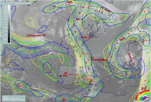
|
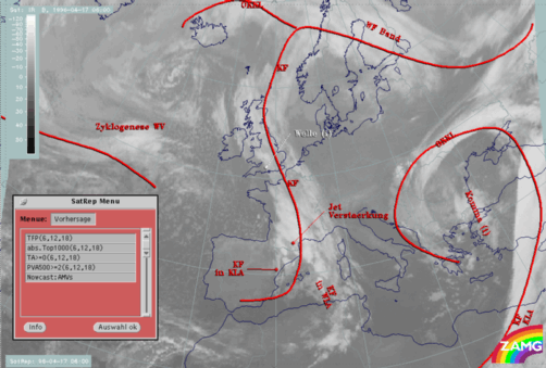
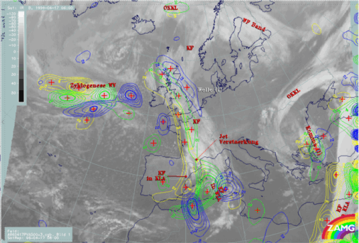
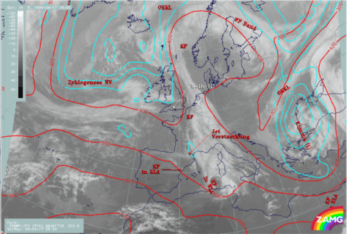
17 April 1996/06.00 UTC - Meteosat IR image; yellow: height contours 1000 hPa 06.00 UTC, green: height contours 1000 hPa 12.00 UTC, blue: height
contours 1000 hPa 18.00 UTC; SatRep overlay: names of conceptual models
|
17 April 1996/06.00 UTC - Meteosat IR image; yellow: temperature advection - WA 1000 hPa 06.00 UTC, green: temperature advection - WA 1000 hPa
12.00 UTC, blue: temperature advection - WA 1000 hPa 18.00 UTC; SatRep overlay: names of conceptual models
|
|
|
|
|
|
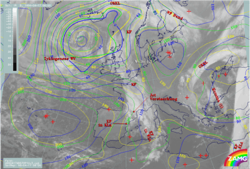
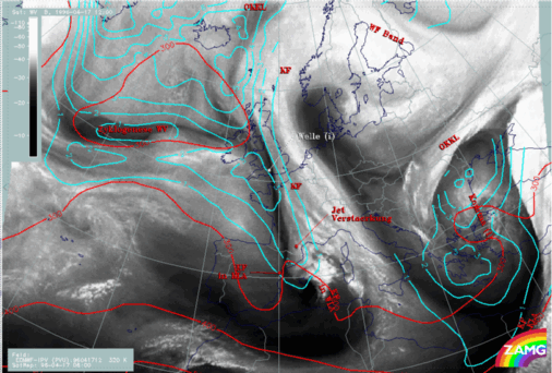
17 April 1996/06.00 UTC - Meteosat IR image; yellow: positive vorticity advection (PVA) 500 hPa 06.00 UTC, green: positive vorticity advection
(PVA) 500 hPa 12.00 UTC, blue: positive vorticity advection (PVA) 500 hPa 18.00 UTC; SatRep overlay: names of conceptual models
|
For this Wave development which does not fit fully into the classical conceptual model because of the deviating behaviour of the temperature advection field, an additional parameter has been taken into account: PV on two isentropic surfaces (compare Wave ). Forecast PV fields can help for decide about further development or decrease of the Wave.
|
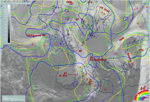
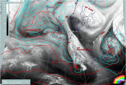
17 April 1996/12.00 UTC - Meteosat WV image; cyan: potential vorticity (PV) 320K, red: isobars; SatRep overlay: names of conceptual models
|
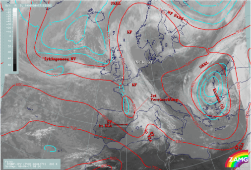
17 April 1996/18.00 UTC - Meteosat WV image; cyan: potential vorticity (PV) 320K, red: isobars; SatRep overlay: names of conceptual models
|
|
|
|
|
|
17 April 1996/12.00 UTC - Meteosat WV image; cyan: potential vorticity (PV) 305K, red: isobars; SatRep overlay: names of conceptual models
|
17 April 1996/18.00 UTC - Meteosat WV image; cyan: potential vorticity (PV) 305K, red: isobars; SatRep overlay: names of conceptual models
|
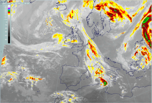
Consequently from the PV fields no Rapid Cyclogenesis can be deduced but rather, taking all forecast parameters into account, a slow further development of the Wave. The images below confirm these ideas. The narrowing of the cloud band mentioned before fits well together with the dry air, although an exact forecast of cloud boundaries from this material seems to be rather difficult.
|
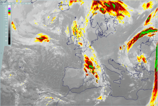
17 April 1996/06.00 UTC - Meteosat IR enhanced image
|
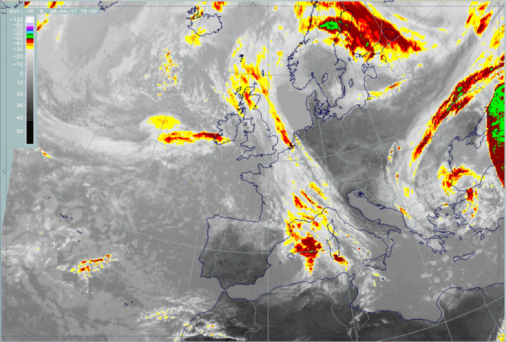
17 April 1996/12.00 UTC - Meteosat IR enhanced image
|
|
|
|
|
|
17 April 1996/18.00 UTC - Meteosat IR enhanced image
|


