Water Vapour Vortices - Meteorological Physical Background
by KNMI and FMI
|
|
|
|
|
|
|
|
|
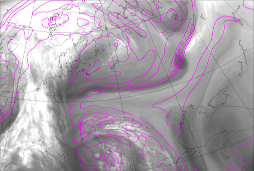
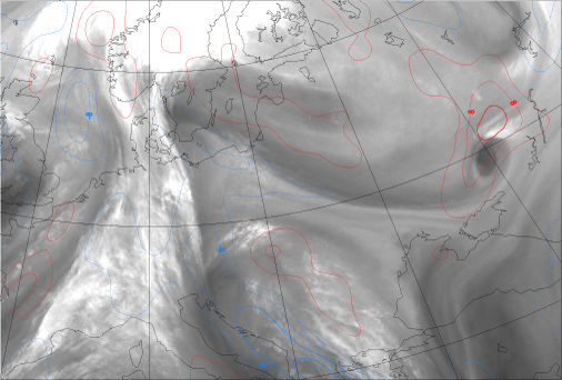
13 January 2008/12.00 UTC - Meteosat WV 6.2 image; magenta: potential vorticity 315K
|
14 January 2008/00.00 UTC - Meteosat WV 6.2 image; magenta: potential vorticity 315K
|
|
|
|
|
|
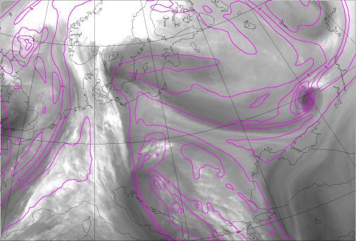
14 January 2008/12.00 UTC - Meteosat WV 6.2 image; magenta: potential vorticity 315K
|
Discussion
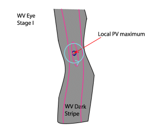
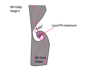
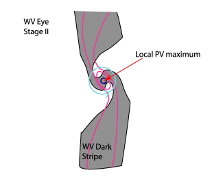
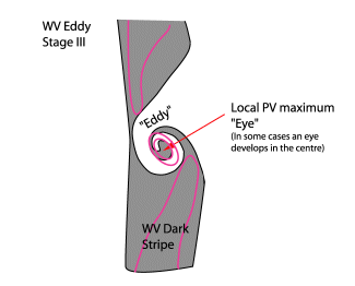
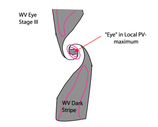
Research of numerous cases has shown that, based on the WV imagery, a distinction between two prevailing structures can be made: The WV Eddy and the WV Eye. However, in the investigation a simple scientific reason for the different structures can't be given. There are some ideas about the connection between the strength of the shear zone and the width and the angle of the PV-anomaly: To surround a dry area (eye) you need a relative broad PV-trough. However, the spatial resolution of the model fields used is not high enough to confirm this hypothesis.The model fields show similar characteristics for the two different structures. Therefore, in the next chapters, no distinction will be made between the WV Eddy and the WV Eye.
WV Vortices often exist in front of frontal zones; consequently there are no distinct or intensive cloud structures. The reason that no other distinct cloud structures exist, is due to the fact that WV Vortices mainly develop in the upper levels of the troposphere. There is less cloud development in the lower levels because the lower parts of the troposphere often show a stable stratification, or insufficient moisture. This is one of the main differences with the conceptual model Upper Level Low. (See Upper Level Low and look at the table below). In the case of an Upper Level Low, the lower troposphere shows an unstable stratification and, as a consequence, clouds develop as convection occurs.
Weinand (2000) has considered possible reasons for formation of multiple mesoscale water vapour vortices (WV Eyes) and proposes three possible forcing mechanisms: a) Horizontal wind shear and jet streaks, b) barotropic instability and c) orography. Particularly the horizontal wind shear and the stretching deformation are promising hypotheses for the explanation of the formation of the eddies. Strongly positive values of stretching deformation implicate a region with strong horizontal wind shear in which the eddies can be maintained.
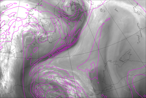
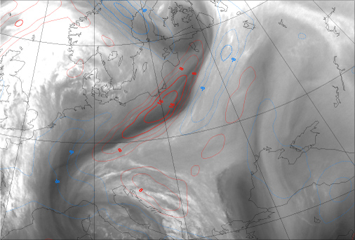
An example of the connection between stretching deformation and wv vortices is shown below. Very strongly positive values of stretching deformation (over 16 x 10-5 s-1 ) are closely associated with the onset of WV Eye formation east of Poland on 13 January 12.00 UTC. Later the absolute values of stretching deformation gradually decrease.
|
13 January 2008/12.00 UTC - Meteosat WV 6.2 image; stretching deformation, blue: negative, red: positive.
|
14 January 2008/00.00 UTC - Meteosat WV 6.2 image; stretching deformation, blue: negative, red: positive.
|
|
|
|
|
|
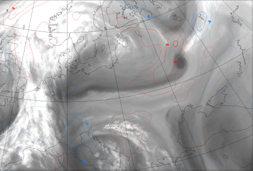
14 January 2008/12.00 UTC - Meteosat WV 6.2 image; stretching deformation, blue: negative, red: positive.
|
As already mentioned, a smaller scale trough is often superimposed on a large scale trough resulting in a small scale vortex. Smaller troughs are mobile and therefore WV Vortices move with the general flow. The reason for the movement of small troughs can be explained relatively simply.
From the geopotential tendency equation it can be seen that advection of vorticity can lead to the change of the geopotential height pattern. This vorticity advection term consistst of two parts: Advection of relative vorticity, and advection of earth's vorticity.
The relative vorticity can be writen as:
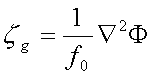
where ζg is the relative (geostrophic) vorticity, f0Coriolis parameter, ∇2 Laplacian operator, φ geopotential height.
From this equation it can be seen that the relative vorticity is proportional to the Laplacian of the geopotential height field. If we suppose that the geopotential height field is a sinusoid it can be shown that:
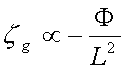
where L is the wavelength of the sinusoid.
The relative vorticity is inverse proportional to the square of the wavelength of the sinusoid. Note that the relative vorticity is inversely proportional to the square of the wavelength of the sinusoide. The shorter the sinusoidal wave, the stronger the vorticity will be. It can also be shown that the Earth's vorticity is inverse proportional to the wavelength of the sinusoid, therefore, relative vorticity will dominate the behaviour of short Waves and the earth's vorticity will dominate the long Waves. As a consequence, a WV Vortex, which is related to a short Wave, tends to move quickly. However, an Upper Level Low which is associated with a large scale trough, is stationary or may even retrograde.
The differences and similarities between a WV Vortex and an Upper Level Low are listed in the tables below.
| Differences | ||
| WV-vortex (Eye/Eddy) | Upper Level Low | |
| Process | Small upper level cyclonic circulation, often embedded in a large scale upper level trough | Cut-off process from a large scale Rossby Wave |
| Cloudiness | Can only be seen in WV imagery. Sometimes small convective cloud cells develop which can also be seen in IR and VIS imagery | Vigorous convective activity develops especially in the mature stage which can be clearly seen in all channels |
| Scale | Small scale/ Mesoscale system | Synoptical scale system |
| Velocity | Moving system, associated with a mobile trough | Associated with a quasi-stationary trough | Similarities |
| Timescale | Persistent, can last for several days | WV imagery | Both appear as a cyclonic circulation of dry and moist air streams. |


