FLOOD CATASTROPHE 10 - 13 AUGUST 2002 - DEVELOPMENT FROM WAVE INTO OCCLUSION STAGES
by ZAMG
Cloud systems in the development phase: Wave into Occlusion
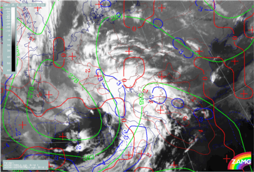
During the 11th of August Mediterranean lows develop and then develop further into an Occlusion cloud spiral: This can easily be seen in the satellite image loops (IR, WV and VIS); once again, several processes at meso- and synoptic-scale can be identified.
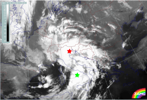
At 00.00 UTC there are two areas of interest:
- A cloud spiral over mid Italy (red star in loop above)
- A cloud intensification area over the Thyrrenian Sea (green star in loop above)
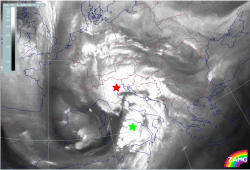
Up to 06.00 UTC the following processes can be observed:
- A NNE-ward shift of both systems:
- The cloud spiral over mid Italy developing into a large Occlusion spiral, extending N-ward over Bavaria, Switzerland and the W. Alps; cloudiness of this Occlusion spiral starts to decay in the second half of this phase (red star in loop above)
- The intensification area develops into a Wave bulge and then into a well developed cloud spiral, extending over SE-Austria, Slovenia and finally over the whole of Austria (green star in loop above).
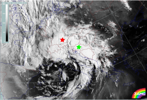
At 12.00 UTC a new Wave - like bulge can be seen over Croatia which develops from a convective area, moves N-ward and further develops into a second circulation (low) at the Occlusion cloud band (yellow star in loop above).
- The cloud spiral (red stars) and the intensification area over mid Italy (green stars)
- A new wave and spiral development over Croatia (yellow stars)
In addition to the information from the IR images, pronounced Dark Stripes seen in the WV images, separate the cloud systems and indicate the different flow of dry air around the huge Upper Level Low.
Synoptic situation of the phase of development from Wave into Occlusion: relevant numerical parameters
In loops of imagery with relevant numerical parameters, such as frontal, Wave and upper level parameters for 11 August, the different processes detected in the cloud features are generally well supported by the model fields.
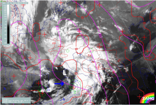
At 00.00 UTC there are already some indications for a Wave over mid Italy in the model parameters:
- There is a very distinct bulge of WA and a CA maximum over the Thyrrenian Sea (behind the cloud spiral over mid Italy and the cloud intensification area.
- The PVA maximum, in the ideal case, following the rear of a Wave bulge, is shifted SW into the cloud intensification area.
At 12.00 UTC, when a new Wave can be seen over Croatia, the model fields show some indications of a Wave. In particular, a small new bulge of CA protrudes to the NE.
Finally at 18.00 UTC the relevant Wave parameters are again well developed in the area of the 2nd low now appearing in the Occlusion cloud band. A separate maximum of CA which has deepened and split-off from the whole CA area is finally connected with the new 2nd low in the Occlusion cloud band.
Generally speaking one can say that there are distinct frontal conditions in thickness, TFP and TA:
A zone of high gradient in thickness accompanies the Cold Front and there is a large ridge in the area of the Occlusion bands; the ridge becomes more pronounced with the development of the second Wave into an Occlusion cloud band; a secondary ridge might even be recognised within the main ridge.
While the TFP accompanies the thickness zone and Cold Front cloud bands close to the rear side very well, the Occlusion cloud band is not accompanied by a separate TFP in the area of the large thickness ridge. This might be a consequence of the extended ridge, where changes of gradients might be too small to exceed the threshold for the TFP.
The zero-line of TA is close to the cloud band, moving from the rear side of the system to the leading edge by the end of the case.
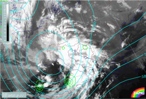
At 300 hPa pronounced PVA maxima can also be distinguished, located at the rear of the Cold Front and Occlusion cloud bands. As there are also well developed jet streaks it cannot be determined if the PVA maxima are caused by shear or curvature. There is, however, a distinct connection between the PVA max in the left exit region of a huge jet streak and the 2nd low developing over Croatia, which then moves north-ward (12.00 - 18.00 UTC).


