14 - 15 JUNE 1998 - 14 JUNE/18.00 UTC: FRONTAL DIAGNOSIS
by FMI
Satellite Overview
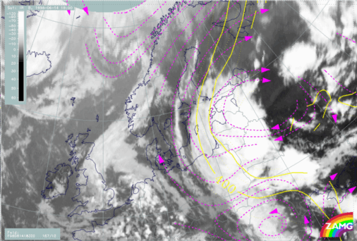
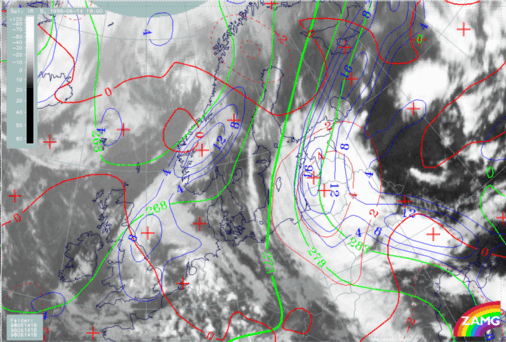
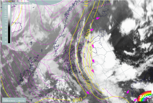
We continue with a more thorough analysis of the frontal cloud bands from 14 June 06.00 UTC. By 18.00 UTC a Warm Front cloud band is stretching from Poland over White Russia to the Baltic States and Finland (H33a). Precipitation is observed within the southern part of the Warm Front and many thunderstorms were reported along the eastern parts of the Warm Front.
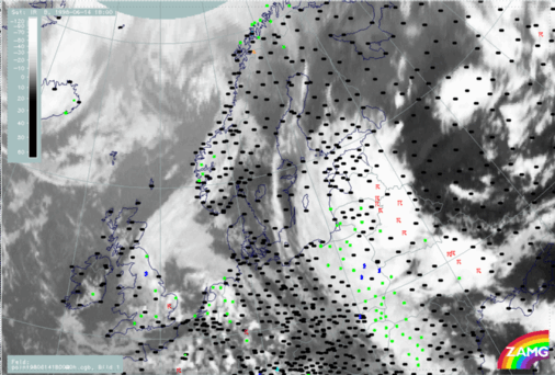
14 June 1998/18.00 UTC - Meteosat IR image; weather events (green: rain and showers, blue: drizzle, cyan: snow, red: thunderstorm with precipitation,
purple: freezing rain, orange: hail, black: no actual precipitation or thunderstorm with precipitation)
Parameters on isobaric surfaces
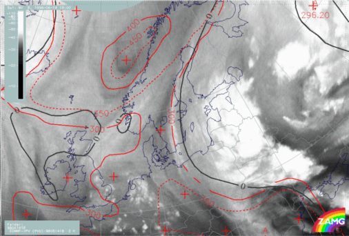
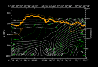
In Fig. H34 there is a distinct WV band over Finland with a sharp edge to a darker stripe over Sweden. The zero line of shear vorticity lies close to this westward boundary but approximately 1 - 2 degrees more to the east. The transition between tropospheric and stratospheric air at 300 hPa is very close to the sharp WV boundary. The eastward displacement of the zero line of shear vorticity when compared to the dry stripe in WV does not match the classical ideas, and could be interpreted as a model error.
14 June 1998/18.00 UTC - Meteosat WV image; red: height of PV=2 units, black: shear vorticity 300 hPa
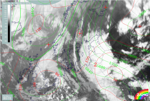
14 June 1998/18.00 UTC - Meteosat IR image; red: height contours 1000 hPa, green: height contours 500 hPa
14 June 1998/18.00 UTC - Meteosat IR image; blue: thermal front parameter (TFP) 500/850 hPa, green: equivalent thickness 500/850 hPa, red: temperature
advection - CA 1000 hPa
Vertical Cross Sections
The vertical cross-section line lies perpendicular to the Warm Front cloud band and its unstable areas. The orientation lies close to east to west (H37).
14 June 1998/18.00 UTC - Meteosat IR image; position of vertical cross section indicated
Isentropes and satellite pixel values
There are two interesting areas in the isentropes (Fig. H38):- An extremely unstable air mass from the surface up to 650 hPa east of the WF and
- A distinct WF zone with high gradients from the surface, at approximately 56N/23E, up to 300 hPa over 56N/12E.
Relative humidity
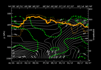
A zone of high humidity values (90 %) is situated over the Warm Fronts zone (H38). The lowest values (20 - 30%) appear below the frontal zone (below 304K at 56N/14E). This is to be expected in a Warm Front of band type.
14 June 1998/18.00 UTC - Vertical cross section; white: isentropes (ThetaE), green: relative humidity, orange thin: IR pixel values, orange thick: WV
pixel values
Warm advection
In Fig. H39 warm advection dominates the vertical cross section with highest values within the WF zone. There are high values also in the area of the unstable air, but only up to 700 hPa. Not a typical distribution of warm advection in a Warm Front.
14 June 1998/18.00 UTC - Vertical cross section; white: isentropes (ThetaE), green thin: temperature advection - CA, green thick: temperature
advection - WA, orange thin: IR pixel values, orange thick: WV pixel values
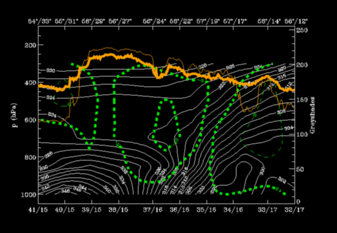
Convergence
The convergence field in Fig. H40 is not pronounced. The only region indicating a frontal convergence zone is the lowest layer of the WF at 850 hPa around 56N/22E, but even there it is quite weak. Even so it also has some of the qualities of a Warm Front cloud band.
14 June 1998/18.00 UTC - Vertical cross section; white: isentropes (ThetaE), green thin: divergence, green thick: convergence, orange thin: IR pixel
values, orange thick: WV pixel values
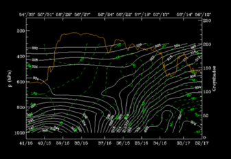
Vertical motion
An extensive zone of upward motion is located on the WF as well as to the rear, above the unstable area (H41). A distinct area of descending air lies between these zones. As before the upward motion is typical for a Warm Front cloud band.
14 June 1998/18.00 UTC - Vertical cross section; white: isentropes (ThetaE), green thick: vertical motion (omega) - upward motion, green thin: vertical
motion (omega) - downward motion, orange thin: IR pixel values, orange thick: WV pixel values
With help of parameters on isentropic surfaces: Air mass separation
Selection of relevant isentropic surfaces (Fig. H42):- 312K: to see what happens within the WF surface in the middle and low part of the zone.
- 322K: to observe the situation partly directly on top and partly further above the WF surface. (Relative streams on 322K can only be evaluated from the eastward boundary westwards to 56N/24E because of intenive instability below.)
14 June 1998/18.00 UTC - Vertical cross section; white: isentropes (ThetaE), green: relative humidity, orange thin: IR pixel values, orange thick: WV
pixel values
14 June 1998/18.00 UTC - Meteosat IR image; magenta: relative streams 312K, yellow: isobars
14 June 1998/18.00 UTC - Meteosat IR image; magenta: relative streams 322K, yellow: isobars