14 - 15 JUNE 1998 - 14 JUNE/06.00 UTC: FRONTAL DIAGNOSIS
by FMI
Frontal analysis
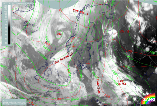
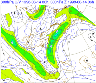
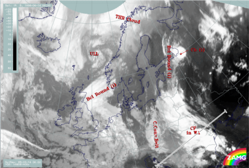
We concentrate on the area of frontal cloud bands stretching from Romania to Finland (H04).The surface (1000 hPa height contour) shows a flat indistinct low over the Balkan Peninsula and the Black Sea and a secondary weak minimum over the Baltic States. From the synoptic analysis of surface observations (not shown), one centre of the Balkan Peninsula low lies just within the area of the CF in WA, but over the Baltic States no center can be found. The 500 hPa height contours show a very pronounced upper level trough in the area of the CCB Occlusion. The many parallel contours reaching from Poland to Finland indicate a broad upper level flow from south to north or northeast. The 300 hPa isotach field (Fig. H04B) shows this even clearer; a moderate jet stretching from the western Black Sea over Finland then all the way up to the Barents Sea.
|
14 June 1998/06.00 UTC - Meteosat IR image; red: height contours 1000 hPa, green: height contours 500 hPa
|
14 June 1998/06.00 UTC - black: height contours 300 hPa, blue: isotachs
|
|
|
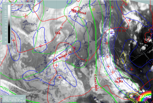
14 June 1998/06.00 UTC - Meteosat IR image; green: height contours 500 hPa , red: temperatures advection - WA 500 hPa, yellow: positive vorticity
advection (PVA) 500 hPa
Vertical Cross Sections
The vertical cross-section line lies perpendicular to the CF in WA with orientation from the cold to the warm side (SW-NE), as shown in image H08.
14 June 1998/06.00 UTC - Meteosat IR image; SatRep overlay: names of conceptual models; position of vertical cross section indicated
Isentropes and satellite pixel values
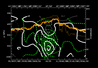
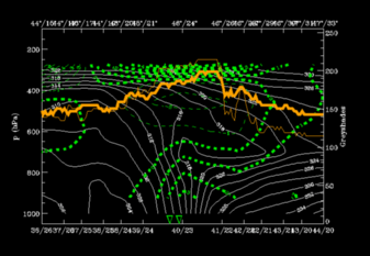
In fig. H09 there is a high gradient of isentropes (~ 310-316K) from 400 hPa at 44N/14E down to the surface at 46N/24E, which indicates a frontal zone. Very unstable air is situated immediately ahead of the frontal zone from the surface up to 650 hPa. The cloudiness is represented by a broad peak of grey shades (45N/22E - 46N/26E) in front of the frontal zone and in the unstable area. Some rainshowers were reported along the front.
Temperature advection
WA can be found within and ahead of the frontal zone but only up to 650 hPa. Upper-air cold advection is overrunning the frontal zone, which clearly increases the instability. This is the more unusual type of CF in WA, because usually the WA is situated above the CA which weakens the front, however, in this case, the front is intensifying.
14 June 1998/06.00 UTC - Vertical cross section; white: isentropes (ThetaE), green thin: temperature advection - CA, green thick: temperature
advection - WA, orange thin: IR pixel values, orange thick: WV pixel values
14 June 1998/06.00 UTC - Vertical cross section; white thin: divergence, white thick: convergence, green thick: vertical motion (omega) - upward
motion, green thin: vertical motion (omega) - downward motion, orange thin: IR pixel values, orange thick: WV pixel values