14 - 15 JUNE 1998 - OVERVIEW OF SATELLITE FEATURES AND CONCEPTUAL MODELS
by FMI
Introduction
This case study describes a weather episode, which is typical for eastern and northeastern Europe in summer.The most common track for the low pressures reaching the Scandinavian and Baltic countries is from the Atlantic, from southwest or west. Yet these countries regularly experience cyclone passages either
- From the northwest (the Norwegian and the Arctic Sea). This area is a typical source for wintertime cyclones bringing snowstorms and heavy winds. (For example, see Case Study 29 - 30 January 1998 ).
- Or from south-southeast (the Balkan region and the Black Sea region). Cyclones generated over this area have characteristic features that are dealt within this case study. Among the meteorological community a common term "Black Sea low" (henceforth referred to as "BS lows" is used) even if the origins of the low pressure might not necessarily be exactly over the the Black Sea, but more generally over the southeastern Europe.
|
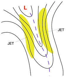
Schematic image showing an extensive upper level trough and the jet streams on its both sides
|
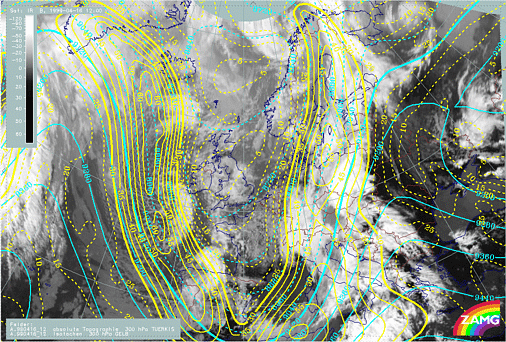
16 April 1998/12.00 UTC - Meteosat IR image; cyan: height contours 300 hPa, yellow: isotachs
|
|
|
- They can be re-generated low pressures which travel from the Mediterranean countries northeastwards, possibly beginning already to fill up, but then starting to deepen again, taking a turn towards north or northeast. This type of development takes place most often in late summer and early autumn.
- Alternatively the low pressure can be formed along the (stationary) front which extends from southeast Europe towards north or northwest. This stationary front is located on the leading (eastern) side of a extensive upper level low, which may be either at its tear-off or cut-off stage. Sometimes this stationary front can be non-developing for days, with weak waves travelling along the front not deepening.
It has to be kept in mind, however, that the waves being "weak" does not mean that the accompanying weather would be weak. The stationary or semi-stationary front represents a distinct air-mass boundary with very distinct changes in temperature and wind and along which the accumulated precipitation amount due to prolonged rainfall can be very high.
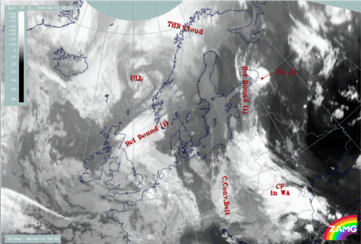
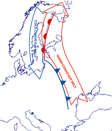
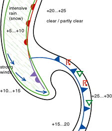
A typical configuration of main conveyor belts, surface fronts and accompanying weather is shown on the images below.
|
|
It is also evident that even small errors in forecasting the low pressure tracks may lead to significant errors in the actual weather forecast. As the precipitation areas on BS lows are elongated and narrow and they approach the forecast area with their "nose" in front, one forecast point can receive little or no precipitation while the adjacent point gets heavy and prolonged precipitation. This fact makes the correct forecasting of these systems challenging.
The case described below is very similar to the classic situation shown above.
Initial state satellite features and conceptual models
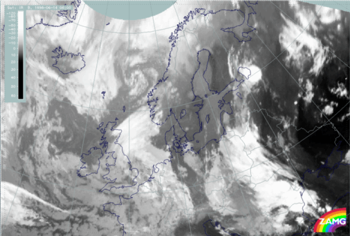
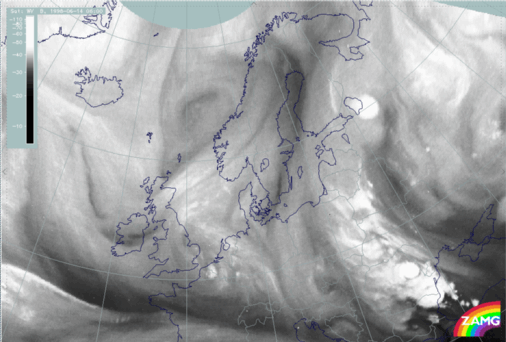
The IR, VIS and WV satellite images of the 14th June 06.00 UTC show the initial state of this case study, with warm air moving from the Black Sea to Finland.From the IR image (H00) it can be seen that between the warm airmass over Russia and eastern parts of the Ukraine, White-Russia and the colder airmass over Scandinavia and central Europe there is a long structured band of clouds. Over Romania and Poland it looks like a frontal cloud band with cold cloud tops and embedded convective cells. Further to the north (Baltic states and Eastern Finland) the cloud looks more like an anticyclonically curved cloud band. It has lower cloud tops than the frontal clouds, but it is connected with a huge circular MCS around 60N/33E. Over the Czech Republic and Austria the cloud bands resemble an Occlusion of the Cold Conveyor Belt type.
Furthermore there seems to be a cyclonic eddy structure over the Norwegian Sea centered at 65N/03E with extended cyclonically curved cloud bands along the boundaries. These features are indicative of an Upper Level Low (ULL). A distinct cloud band over the North Sea from England to Norway has the structure of a Baroclinic Boundary and might be associated with the ULL. However, in this case study we only concentrate on the clouds over eastern Europe.