15 - 16 MARCH 1998 - 09.00 - 12.00 UTC - FRONTAL DIAGNOSIS - RELATIVE STREAMS AND CONVEYOR BELTS
by ZAMG
|
15 March 1998/12.00 UTC - Meteosat IR image; position of vertical cross section indicated
|
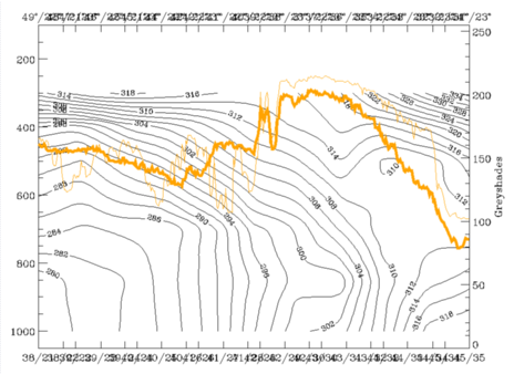
15 March 1998/12.00 UTC - Vertical cross section; black: isentropes (ThetaE), orange thin: IR pixel values, orange thick: WV pixel values
|
|
|
|
Looking again at the right figure, the following isentropic surfaces can be selected which represent the two frontal zones best: 304K is a surface connecting both frontal systems: in low layers it is within the southern frontal zone and in upper layers it is on top of the northern frontal system.
15 March 1998/12.00 UTC - Meteosat IR image; weather events (green: rain and showers, blue: drizzle, cyan: snow, red: thunderstorm with precipitation,
purple: freezing rain, orange: hail, black: no actual precipitation or thunderstorm with precipitation), magenta: relative streams 304K - system
velocity 284° 7 m/s, yellow: isobars
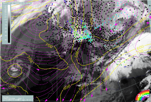
Relative streams on 304K show a very classical and very pronounced behaviour. There is a strongly rising and splitting relative stream similar to a Warm Conveyor Belt within the white cloud band of the southern front. It is connected with extended precipitation over the Peloponnesus and the adjacent sea areas. A limiting stream line appears close to the northern edge of the white cloud band separating the Warm Conveyor Belt from a relative stream from the north which is
representing a dry intrusion. This relative stream is sinking from 400 hPa down to about 600 - 650 hPa and turning to north-eastern directions over north Greece where it begins to rise again.
So these are rather classical conditions of the conveyor belt theory representing a well-developed and intensive frontal system.