29 - 30 JANUARY 1998 - PVA AND JET STREAK DIAGNOSIS
by FMI
|
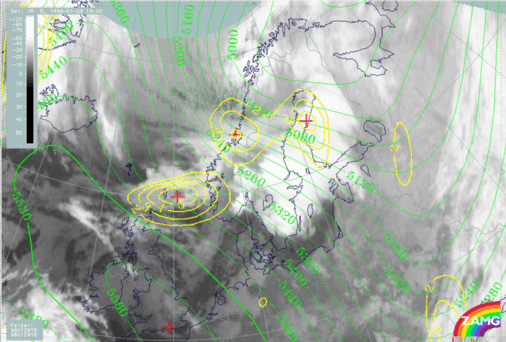
29 January 1998/18.00 UTC - Meteosat IR image; green: height contours 500 hPa, yellow: positive vorticity advection (PVA) 500 hPa
|
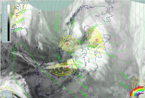
30 January 1998/00.00 UTC - Meteosat IR image; green: height contours 500 hPa, yellow: positive vorticity advection (PVA) 500 hPa
|
|
|
|
|
|
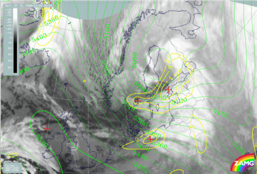
30 January 1998/06.00 UTC - Meteosat IR image; green: height contours 500 hPa, yellow: positive vorticity advection (PVA) 500 hPa
|
By 00.00 UTC on 30 January (right image top) all three PVA maxima are distinct. The PVA maximum associated with the occluding system over Finland has increased due to the formation of the Upper level Low over the Bay of Bothnia. Therefore curvature vorticity is a driving factor. The PVA maximum over Norway (63N/10E) is also connected with an upper level trough and superimposed on the cold frontal band.
The double structure of PVA at 500 hPa holds until 06.00 UTC on 30 January (left image bottom), though the individual PVA maxima are merging.
|
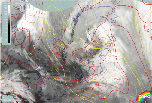
29 January 1998/18.00 UTC - Meteosat IR image; yellow: isotachs 300 hPa, red: positive vorticity advection (PVA) 300 hPa
|
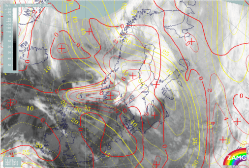
30 January 1998/06.00 UTC - Meteosat IR image; yellow: isotachs 300 hPa, red: positive vorticity advection (PVA) 300 hPa
|
|
|
The associated PVA field on 29 January at 18.00 UTC (left image) shows a complex situation with an unclassical pattern of PVA and jet streaks. The inspection of shear and curvature vorticity patterns (not shown) indicates that the reason for this untypical PVA field is the intensive curvature of the upper level trough.
On 30 January at 06.00 UTC (right image) the original jet streak, which had existed from the very beginning and which was not well located and structured in the ECMWF analysis is now decaying; the remnants of it can be noticed over the Baltic Sea and the Baltic States. The jet streak rushing from the Norwegian Sea towards south Scandinavia has strengthened, and an associated PVA maximum can be found in the classical position - on the left exit area of the jet streak.


