29 - 30 JANUARY 1998 - RAPID DEVELOPMENT - CROSS SECTIONS
by FMI
|
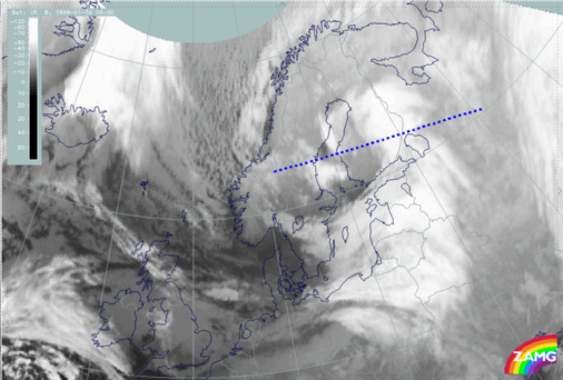
30 January 1998/06.00 UTC - Meteosat IR image; position of vertical cross section indicated
|
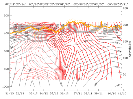
30 January 1998/06.00 UTC - Vertical cross section; black: isentropes (ThetaE), red thin: temperature advection - CA, red thick: temperature
advection - WA, orange thin: IR pixel values, orange thick: WV pixel values
|
|
|
|
|
|
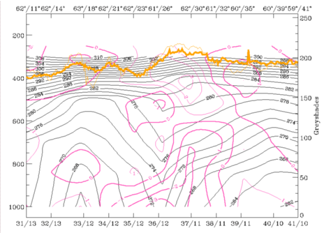
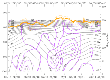
30 January 1998/06.00 UTC - Vertical cross section; black: isentropes (ThetaE), magenta thin: divergence, magenta thick: convergence, orange thin:
IR pixel values, orange thick: WV pixel values
|
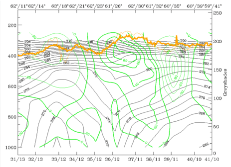
30 January 1998/06.00 UTC - Vertical cross section; black: isentropes (ThetaE), green thick: vorticity advection - PVA, green thin: vorticity
advection - NVA, orange thin: IR pixel values, orange thick: WV pixel values
|
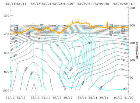
A frontal zone of convergence (left image bottom) accompanies the lower part of the Occlusion and the Warm Front part. An increase of PVA (right image bottom) with height takes place within the Occlusion part; no PVA maximum is associated with the EC area. Intensive upward motion as a consequence of warm advection, convergence and PVA is concentrated around the Occlusion. There also seems to be sinking motion (left image below) in the area of cold advection to the west as well as to the east. In reality the sinking motion in the west is not exactly true: there was clearly convective precipitation connected to the EC cloudiness, as verified by radar (compare Diagnosis of precipitation patterns with help of relative streams and NORDRAD radar composites).
|
30 January 1998/06.00 UTC - Vertical cross section; black: isentropes (ThetaE), cyan thick: vertical motion (omega) - upward motion, cyan thin:
vertical motion (omega) - downward motion, orange thin: IR pixel values, orange thick: WV pixel values
|
30 January 1998/06.00 UTC - Vertical cross section; black: isentropes (ThetaE), lilac: Q-Vector (normal component), orange thin: IR pixel values,
orange thick: WV pixel values
|
|
|


