29 - 30 JANUARY 1998 - DIAGNOSIS OF SURFACE AND UPPER LEVEL LOWS

by FMI


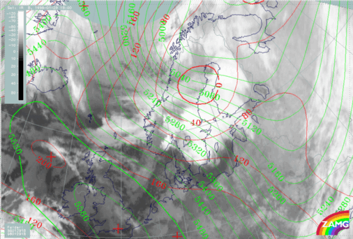
29 January 1998/18.00 UTC - Meteosat IR image; red: height contours 1000 hPa, green: height contours 500 hPa
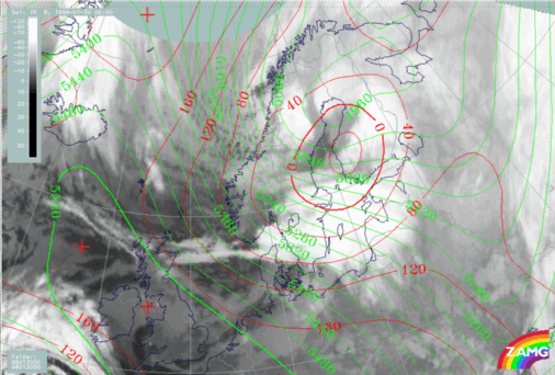
30 January 1998/00.00 UTC - Meteosat IR image; red: height contours 1000 hPa, green: height contours 500 hPa
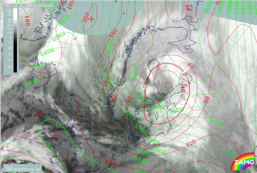
30 January 1998/06.00 UTC - Meteosat IR image; red: height contours 1000 hPa, green: height contours 500 hPa
The development of both the upper trough and surface low was quite rapid. At 18.00 UTC on 29 January (left image top) the inclination of the upper trough-surface low is typical for a developing baroclinic Wave with Upper Wave lagging behind the surface low. At 00.00 UTC on 30 January (right image top) a closed circulation is about to form on the upper flow over the Bay of Bothnia. Six hours later (left image bottom) a closed upper level low is found over west Finland, while an intensive surface low pressure centre can be found still some distance ahead of the Upper Level Low, over south Finland. An Occlusion - like cloud spiral is becoming more and more easy to recognize even in Meteosat IR images. The Comma cloud seen on 29 January 18.00 UTC (left image top) near the Lofoten Islands seems to travel quite fast and - though weakening - the cloud mass is still identifiable at 06.00 UTC on 30 January (left image bottom) over the Sea of Bothnia.

SUB-MENU OF 29 - 30 JANUARY 1998
RAPID DEVELOPMENT - SATELLITE OVERVIEW
DIAGNOSIS OF FRONTAL PARAMETERS