29 - 30 JANUARY 1998 - 06.00 UTC - CROSS SECTIONS
by FMI
|
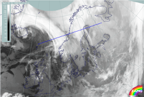
29 January 1998/06.00 UTC - Meteosat IR image; position of vertical cross section indicated
|
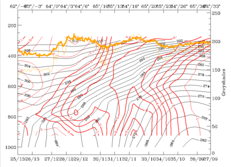
29 January 1998/06.00 UTC - Vertical cross section; black: isentropes (ThetaE), red thin: temperature advection - CA, red thick: temperature
advection - WA, orange thin: IR pixel values, orange thick: WV pixel values
|
|
|
|
|
|
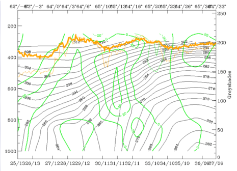
29 January 1998/06.00 UTC - Vertical cross section; black: isentropes (ThetaE), green thick: vorticity advection - PVA, green thin: vorticity
advection - NVA, orange thin: IR pixel values, orange thick: WV pixel values
|
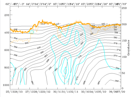
29 January 1998/06.00 UTC - Vertical cross section; black: isentropes (ThetaE), cyan thick: vertical motion (omega) - upward motion, cyan thin:
vertical motion (omega) - downward motion, orange thin: IR pixel values, orange thick: WV pixel values
|
The increase of PVA with height (left image bottom) is evident in the north-eastern cloud band, but the PVA maximum is found at untypically low heights, at around 600 hPa.
The maximum upward motion (right image bottom) can be found at around 65N/13E, where also snowfall was observed. The location of the maximum is probably an indication of orographic effects. (Mountain tops are around 850 - 800 hPa over the area).
As a summary it can be said that the north-eastern cloud band was more developed and active than the south-western cloud band. Later this south-western band became weaker and finally merged with the developing north-eastern cloud band. The presence of two frontal areas close to each other makes the analysis complex. It is evident, though, that the role of the south-western cloud band in the development of Lofoten Islands low pressure was minor. For this reason the analysis concentrates from this point on mainly on the north-eastern cloud band and its development.


