12 - 13 NOVEMBER 1997 - DISPLACEMENT OF THE WAVE
by ZAMG
|
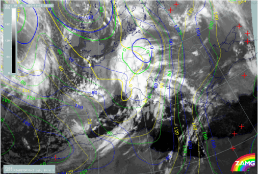
12 November 1997/06.00 UTC - Meteosat IR image; yellow: height contours 1000 hPa 06.00 UTC, green: height contours 1000 hPa 12.00 UTC,
blue: height contours 1000 hPa 18.00 UTC
|
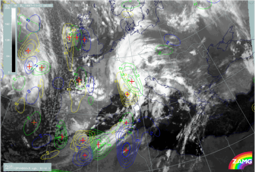
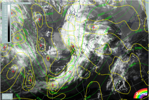
12 November 1997/06.00 UTC - Meteosat IR image; yellow: positive vorticity advection (PVA) 500 hPa 06.00 UTC, green: positive vorticity
advection (PVA) 500 hPa 12.00 UTC, blue: positive vorticity advection (PVA) 500 hPa 18.00 UTC
|
|
|
|
For the Wave several relevant parameters can be inspected. The minimum of the isobaric height close to the surface (1000 hPa, left image) shows a quick displacement to the north-east across Germany to the Czech Republic; but it has to be recognised that there is also a very large low pressure area for instance over north Italy, Switzerland and west Austria. Another parameter useful to follow is PVA at 500 hPa. The right image shows also a north-eastward shift to north-west Italy until 12.00 UTC but a decay to less than 2 units at 18.00 UTC. Comparing with the surface pressure low, the propagation of the PVA maximum until 12.00 UTC is much slower.
|
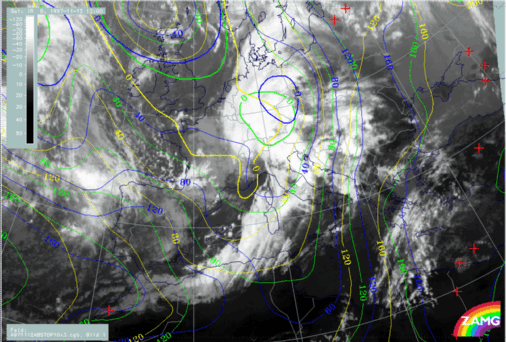
12 November 1997/12.00 UTC - Meteosat IR image; yellow: height contours 1000 hPa 06.00 UTC, green: height contours 1000 hPa 12.00 UTC,
blue: height contours 1000 hPa 18.00 UTC
|
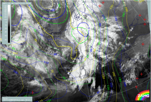
12 November 1997/18.00 UTC - Meteosat IR image; yellow: height contours 1000 hPa 06.00 UTC, green: height contours 1000 hPa 12.00 UTC,
blue: height contours 1000 hPa 18.00 UTC
|
|
|
|
The 12.00 UTC image (left image) has to be compared with the green lines, and it is noticeable that the centre of the spiral over north-west Italy is in the large area of the low pressure trough but not centred at the minimum which is over Germany. The same is true for 18.00 UTC (right image): the spiral over Switzerland is even more displaced from the pressure minimum over the Czech Republic. As the coincidence with the upper level trough (not shown here) is much better, one conclusion could be that the upper level features have a much bigger influence on the cloud configuration.
12 November 1997/06.00 UTC - Meteosat IR image; green: height contours 500 hPa, yellow: positive vorticity advection (PVA) 500 hPa
The image above clearly shows a small scale upper level trough immediately on the rear side of the cloud spiral and a PVA maximum superimposed on it. This will be discussed again in the chapters for the relevant points of time.