12 - 13 NOVEMBER 1997 - FRONTAL DISPLACEMENT WITH HELP OF THE THERMAL FRONT PARAMETER

by ZAMG


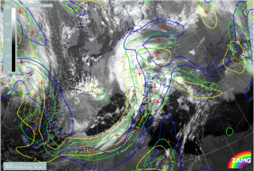
12 November 1997/06.00 UTC - Meteosat IR image; yellow: thermal front parameter (TFP) 500/850 hPa 06.00 UTC, green: thermal front parameter (TFP) 500/850 hPa 12.00 UTC, blue: thermal front parameter (TFP) 500/850 hPa 18.00 UTC
During the next 12 hours until 18.00 UTC the TFP shows a distinct eastward displacement for the cold front and a northward displacement of the Warm Front Band. At 18.00 UTC the TFP of the Cold Front reaches the eastern parts of Slovenia and Croatia and crosses central Austria. As the TFP for 06.00 UTC is close to the leading edge of the Cold Front band, most of Slovenia and Croatia and the eastern part of Austria remain mainly in the thickness ridge during the next 12 hours.
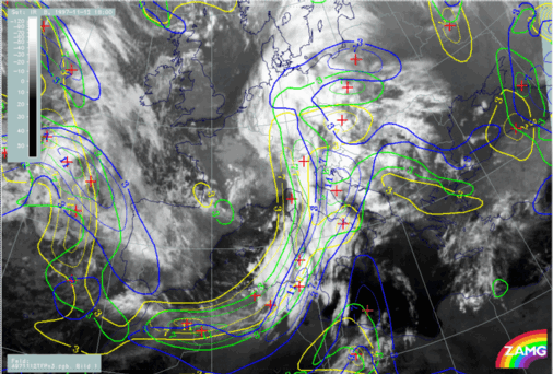
12 November 1997/12.00 UTC - Meteosat IR image; yellow: thermal front parameter (TFP) 500/850 hPa 06.00 UTC, green: thermal front parameter (TFP) 500/850 hPa 12.00 UTC, blue: thermal front parameter (TFP) 500/850 hPa 18.00 UTC
12 November 1997/18.00 UTC - Meteosat IR image; yellow: thermal front parameter (TFP) 500/850 hPa 06.00 UTC, green: thermal front parameter (TFP) 500/850 hPa 12.00 UTC, blue: thermal front parameter (TFP) 500/850 hPa 18.00 UTC
The images above showing the cloud systems at 12.00 and 18.00 UTC confirm the last conclusion; except for several intensifications the TFP remains on the frontal side of the Cold Front cloudiness for both points of time.

SUB-MENU OF 12 - 13 NOVEMBER 1997
CLOUDINESS OVER ITALY AND THE BALKAN PENINSULA IN FRONT OF THE COLD FRONT: RELATIVE STREAMS
DISPLACEMENT OF THE WAVE