12 - 13 NOVEMBER 1997 - CLOUDINESS OVER ITALY AND THE BALKAN PENINSULA IN FRONT OF THE COLD FRONT: RELATIVE STREAMS
by ZAMG
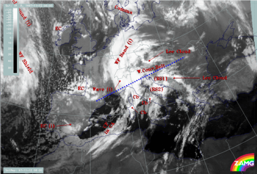
12 November 1997/06.00 UTC - Meteosat IR image; green: equivalent thickness 500/850 hPa, red: temperature advection - WA 1000 hPa
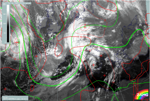
The cloudiness in front of the frontal system has a fibrous character and shows orographic modified cloudiness superimposed. As can be seen from the image above there is a thickness ridge and a big area of WA. Such a cloud configuration is very typical for the rising branches of a Warm Conveyor Belt - a diagnosis which can also be expected from the location in front of the Cold Front (compare
Conceptual Models: Warm Conveyor Belt
).
|
12 November 1997/06.00 UTC - Meteosat IR image; SatRep overlay: names of conceptual models; position of vertical cross section indicated
|
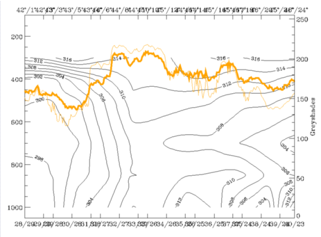
12 November 1997/06.00 UTC - Vertical cross section; black: isentropes (ThetaE), orange thin: IR pixel values, orange thick: WV pixel
values
|
|
|
|
For the characterisation of the Warm Conveyor Belt, relative streams on relevant isentropes are most indicative. The right image above gives an overview over the selected surfaces: 308K is a surface on top of the Cold Front which can be investigated down to about 700 hPa while 312K is a high surface between 300 and 450 hPa.
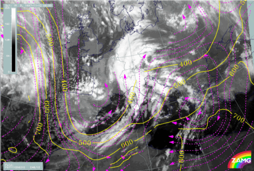
12 November 1997/06.00 UTC - Meteosat WV image; black: shear vorticity 300 hPa, magenta: relative streams 308K - system velocity 248° 12
m/s, yellow: isotachs
On the 308K surface the relative streams involved in the Cold Front in Cold Advection and in the Warm Front Band can be seen very well. There are relative streams over the Atlantic from north to south turning to northern directions again south of Spain. In relation to the Cold Front one can discriminate the wet relative stream from north-west which is on the anticyclonic side of the jet axis (zero line of shear vorticity in black) and the dry intrusion which is on the cyclonic side of the jet axis. The first relative stream is parallel to the cloud band of the Cold Front without any distinct vertical motion but rising in the area of the cloud bulge north of the Wave point. The relative stream lines of the dry intrusion can be found at the rear side of the cloud band and accompany the black area in the WV imagery. Over Croatia, Slovenia, Austria and the Warm Front cloud band a rising relative stream can be recognized which represents on this surface the Warm Conveyor Belt. This situation is a very classical one for a Cold Front and a Warm Front.
|
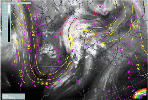
12 November 1997/06.00 UTC - Meteosat IR image; black: shear vorticity 300 hPa, magenta: relative streams 312K - system velocity 248°
12 m/s, yellow: isotachs
|
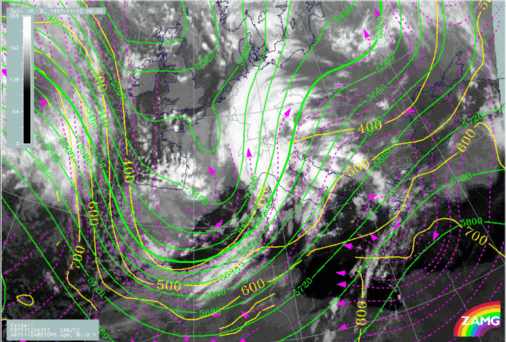
12 November 1997/06.00 UTC - Meteosat IR image; green: height contours 500 hPa, magenta: relative streams 312K - system velocity 248°
12 m/s, yellow: isotachs
|
|
|
|
On the higher isentropic surface of 312K (left image) a very distinct Warm Conveyor Belt can be seen with stream lines rising between 700 - 600 and 400 hPa from Tunisia across Italy, the Adriatic Sea and the Balkan Peninsula. The lines are in front of the Cold Front cloud band and parallel to several cloud lines and cloud features in front of the frontal system. The sinking branch of the Warm Conveyor Belt can be observed east of about 25E. By comparing the absolute stream lines at 500 hPa and the relative ones on the 312K surface (right image) the additional information of relative streams can be seen; although there is a south-west - north-east stream in both fields over Italy and the Balkan Peninsula, air masses of different origins are involved which merge at the leading edge ofthe Cold Front cloud band.
12 November 1997/06.00 UTC - Meteosat WV image; magenta: wind vectors 500 hPa
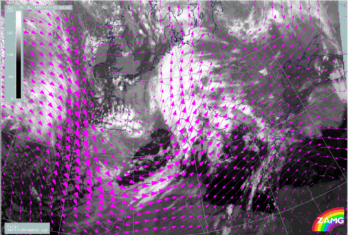
In such cases very often orographic lee cloudiness is superimposed. This can be seen best in the lee of the mountains from Croatia, Bosnia and Yugoslavia as well as in the lee of the Alps in north-east Austria. In the image above the wind vectors clearly show the normal orientation to the mountain ranges. One can conclude from this that the combination of both the overall rising on the inclined isentropic surfaces taking place in the Warm Conveyor Belt and the rising in the lee waves of mountains is responsible for condensation and cloud development there.