12 - 13 NOVEMBER 1997 - INTENSIFICATION OF FRONTAL CLOUDINESS AND ACTIVITY BY JET STREAK CROSSING
by ZAMG
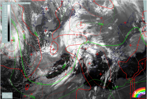
12 November 1997/06.00 UTC - Meteosat IR image; green: equivalent thickness 500/850 hPa, red: temperature advection 1000 hPa
In the chapter
Overview and frontal diagnosis two EC areas have already been mentioned. Both are situated within a thickness trough and the southern one at least is under the influence of CA (image above). In the actual SatRep of this day based on ECMWF forecast fields there was information that this EC is
in the left exit region of a jet streak with only weak PVA and that the height with PV = 2 units is down to 450 hPa; this area should be observed!. Analysis fields used for this case study support this diagnosis strongly.
12 November 1997/06.00 UTC - Meteosat IR image; black: positive vorticity advection (PVA) 300 hPa, yellow: isotachs 300 hPa
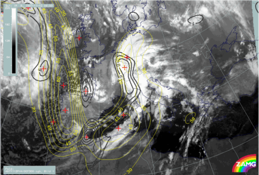
The image above shows a notable jet streak from south Ireland to south Spain with a PVA maximum at 300 hPa superimposed on the low part of the Cold Front in Cold Advection in an area south-east of Spain. The EC is more to the rear of this PVA maximum. Such a situation may be characteristic of the increase of frontal cloudiness and activity through the contribution of PVA to upward motion:
Front intensification (compare
Conceptual Models: Front Intensification by Jet Crossing
).
Indeed, such a development takes place in this case and will be demonstrated in Front Intensification by Jet Crossing.


