12 - 13 NOVEMBER 1997 - WAVE DEVELOPMENT IN THE AREA SARDINIA - CORSICA
by ZAMG
12 November 1997/06.00 UTC - Meteosat IR image; magenta: height contours 1000 hPa, red: temperature advection - WA 1000 hPa, green: positive vorticty advection
(PVA) 500 hPa
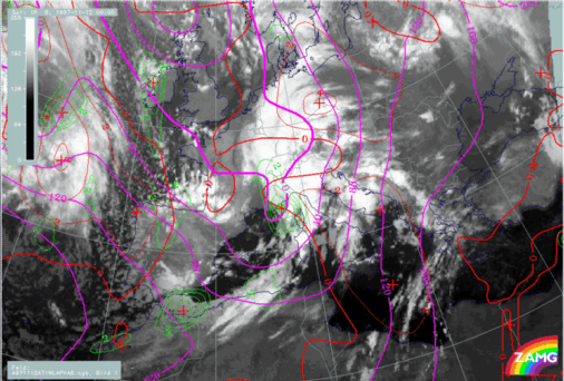
In the image above three parameters relevant for Wave development are combined: height of 1000 hPa, WA and PVA at 500 hPa. In the case of a well-developed Wave a surface minimum, a WA maximum within the cloud bulge and a PVA maximum are signs for an ongoing deepening of pressure and an intensification of the cyclonic circulation. There is an excellent coincidence between the cloud bulge and these parameter features. The only deviating feature is the CA zone north of the Wave point over Switzerland and Austria which has already been discussed before in connection with the Warm Front (compare
Overview and frontal diagnosis).
12 November 1997/06.00 UTC - Meteosat IR image; red: height of PV = 2 units
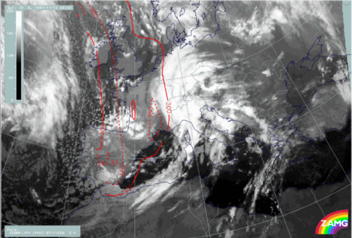
Another interesting parameter in connection with waves is potential vorticity (PV). The image above shows the height of the PV = 2 units surface which is an indication for the height of the tropopause there and separates tropospheric from dry stratospheric air. In the case of a classical Wave development PV = 2 units only extend down to approximately 300 hPa which is confirmed also in this study.
12 November 1997/06.00 UTC - Meteosat IR image; SatRep overlay: names of conceptual models; position of vertical cross section indicated
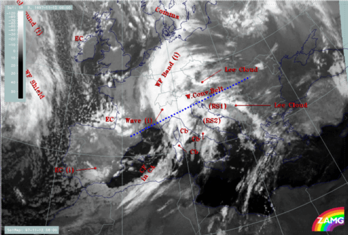
From the vertical cross section, which extends from the Pyrenees across north Italy and Croatia to Romania, additional information about the vertical structure of the troposphere in the area of the Wave can be gained.
|
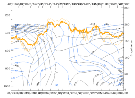
12 November 1997/06.00 UTC - Vertical cross section; black: isentropes (ThetaE), blue: relative humidity, orange thin: IR pixel values, orange thick: WV
pixel values
|
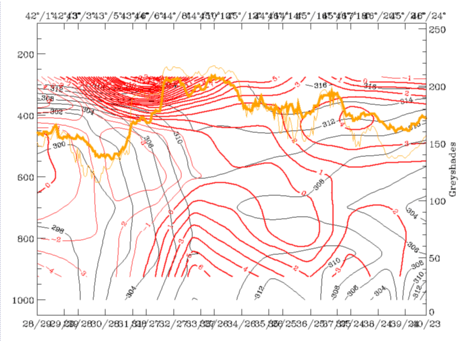
12 November 1997/06.00 UTC - Vertical cross section; black: isentropes (ThetaE), red thin: temperature advection - CA, red thick: temperature
advection - WA, orange thin: IR pixel values, orange thick: WV pixel values
|
|
|
|
|
|
|
|
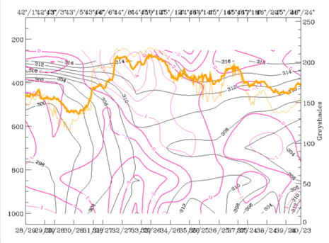
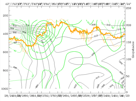
12 November 1997/06.00 UTC - Vertical cross section; black: isentropes (ThetaE), magenta thin: divergence, magenta thick: convergence, orange thin:
IR pixel values, orange thick: WV pixel values
|
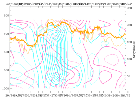
12 November 1997/06.00 UTC - Vertical cross section; black: isentropes (ThetaE), cyan thick: vertical motion (omega) - upward motion, cyan thin: vertical
motion (omega) - downward motion, magenta thin: divergence, magenta thick: convergence, orange thin: IR pixel values, orange thick: WV pixel values
|
The main IR and WV peaks between 44N/08E and 45N/10E correspond to the frontal wave cloudiness, the eastern peak at about 45N/16E represents high lee cloudiness at the Dinaric Alps. Isentropes form a very steep crowding zone from 400 hPa down to the surface over north-west Italy. A tongue of wet air is back-bent on top of the frontal surface and reaches up to 300 hPa.
|
12 November 1997/06.00 UTC - Vertical cross section; black: isentropes (ThetaE), green thick: vorticity advection - PVA, green thin: vorticity
advection - NVA, orange thin: IR pixel values, orange thick: WV pixel values
|
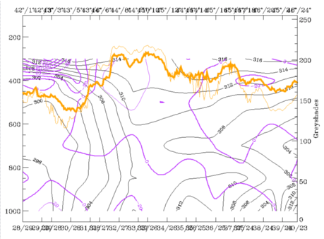
12 November 1997/06.00 UTC - Vertical cross section; black: isentropes (ThetaE), lilac: Q-Vector (normal component), orange thin: IR pixel values, orange
thick: WV pixel values
|
|
|
|
WA in front and on top of, as well as PVA on top of the frontal surface, are both well developed in the Wave area. Convergence has, especially in the lower layers, well-pronounced values. Both convergence and PVA are the reason for very strong upward motion on top of the frontal surface. In contrast to the southern vertical cross section (compare
Overview and frontal diagnosis) which showed frontogenesis in the middle and upper layers, the negative n-component of the Q-vector is rather weak in this area of the front.