12 - 13 NOVEMBER 1997 - OVERVIEW AND FRONTAL DIAGNOSIS
by ZAMG
Besides the overall diagnosis of conceptual models there are three main topics:
- Wave Sardinia - Corsica - Italy
- Front Intensification by Jet Crossing south-east Spain
- Cloudiness in front of Cold Front: relative streams
Thunderstorms and their synoptic environment are discussed in a separate chapter (compare
Development of Thunderstorms and MCSs During the Whole Period).
|
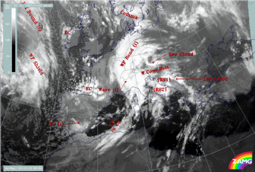
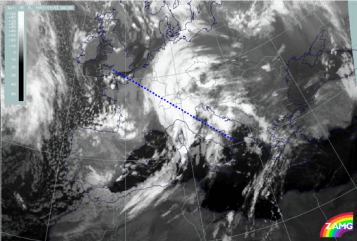
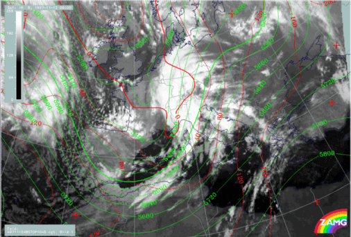
12 November 1997/06.00 UTC - Meteosat IR image; SatRep overlay: names of conceptual models
|
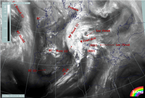
12 November 1997/06.00 UTC - Meteosat WV image; SatRep overlay: names of conceptual models
|
|
|
|
The IR (left image) and WV (right image) satellite images show a frontal cloud system in the centre of the image with a rather narrow Cold Front cloud band extending from Africa northward to Sardinia and Corsica. It is diagnosed as a Cold Front under CA (CF in CA). Over north Italy and the Alpine area a Wave can be identified accompanied by a typical huge cloud bulge; finally a Warm Front cloud band (WF band) extends from Switzerland across Germany to the east border of Poland. The Wave is the subject of a separate discussion (compare
Wave development in the area Sardinia - Corsica).
Behind this frontal system two cold air features labelled with EC (Enhanced Cumuli) can be identified by increased cellular structure; in particular the southern one over south-east Spain will be mentioned in connection with the topic of the Front Intensification by Jet Crossing (JI) (compare Intensification of frontal cloudiness and activity by jet crossing).
In front of the frontal system quite different cloudiness appears: fibrous types interrupted or enhanced by orography and orographic cloudiness. Such a cloud configuration in this area can typically be found in the thickness ridge in front of fronts and will be discussed under the separate topic of relative streams in the chapter Cloudiness over Italy and the Balkan Peninsula in front of the Cold Front: Relative Streams.
The WV imagery gives additional information in three areas:
- There is black, i.e. very dry, air over Spain and also close to the southern EC cloudiness which consequently has much lower tops than the northern one
- There is another very black area at the rear side of the Wave in the Gulf du Lion
- There is a light grey WV band from Tunisia across middle Italy and the Adriatic Sea into the Balkan Peninsula
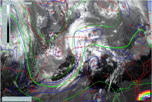
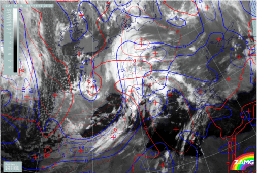
12 November 1997/06.00 UTC - Meteosat IR image; red: height contours 1000 hPa, green: height contours 500 hPa
The image above shows the height distribution close to the surface (1000 hPa) and in the upper levels (500 hPa). At both heights notable troughs can be recognized which are backward inclined against each other. There is a broad surface minimum coinciding with the Wave area. The ECs are more to the rear of the upper level trough axis, indicating that jet streaks with shear vorticity have some important influence there. The cloudiness in front of the frontal system is within a broad south-western stream at upper levels.
12 November 1997/06.00 UTC - Meteosat IR image; blue: thermal front parameter (TFP) 500/850 hPa, green: equivalent thickness 500/850 hPa, red: temperature
advection - CA 1000 hPa
The Cold Front in Cold Advection (CF in CA) is accompanied by a thickness gradient and a thermal front parameter (TFP) which is close to the leading edge of the cloud band. Cold advection (CA) can be recognized already in front of the cloud band, but the largest gradient is within and the strongest CA behind the cloud band. These are conditions which are similar to a classical Cold Front (compare
Conceptual Models: Cold Front
and
Conceptual Models: Cold Front in Cold Advection
).
12 November 1997/06.00 UTC - Meteosat IR image; SatRep overlay: names of conceptual models; position of vertical cross section indicated
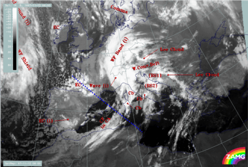
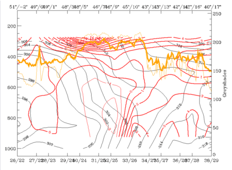
The vertical cross section G extending from the Bay of Biscay across the east Pyrenees and the Cold Front cloud band to Tunisia give more information about the structure of the Cold Front.
|
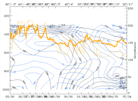
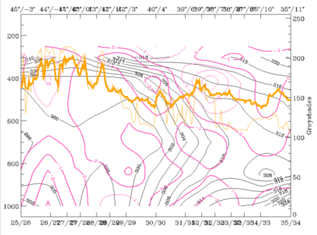
12 November 1997/06.00 UTC - Vertical cross section; black: isentropes (ThetaE), blue: relative humidity, orange thin: IR pixel values, orange thick: WV
pixel values
|
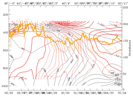
12 November 1997/06.00 UTC - Vertical cross section; black: isentropes (ThetaE), red thin: temperature advection - CA, red thick: temperature
advection - WA, orange thin: IR pixel values, orange thick: WV pixel values
|
|
|
|
|
|
|
|
12 November 1997/06.00 UTC - Vertical cross section; black: isentropes (ThetaE), magenta thin: divergence, magenta thick: convergence, orange thin:
IR pixel values, orange thick: WV pixel values
|
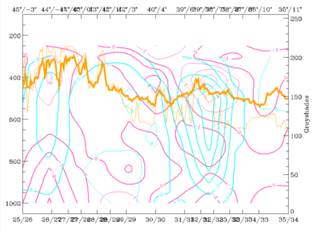
12 November 1997/06.00 UTC - Vertical cross section; black: isentropes (ThetaE), cyan thick: vertical motion (omega) - upward motion, cyan thin: vertical
motion (omega) - downward motion, magenta thin: divergence, magenta thick: convergence, orange thin: IR pixel values, orange thick: WV pixel values
|
The westernmost peak in the IR and WV signals corresponds to the EC cloudiness over the Bay of Biscay, the peak around 39N/07E corresponds to the Cold Front. Isentropes (ThetaE) show a typical frontal surface inclined from 300 - 400 hPa over 42N/03E downward to approximately 750 - 800 hPa. Below this there is a more complicated boundary layer structure within the frontal surface which is superadiabatic as well as behind it. In particular the boundary layer in front with decreasing values of ThetaE represents a stationary warm air pillow. TA (right image top) supports the CA in front of the frontal cloud band but shows clearly that this is only in the lower troposphere up to about 700 - 650 hPa. Above this there is WA on top of the frontal surface, as usual for Cold Fronts. There is also considerable convergence (left image bottom) connected with the frontal surface leading to upward motion on top of it (right image bottom). That means that the circulation cell connected with the Cold Front is well developed.
|
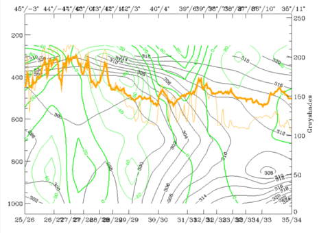
12 November 1997/06.00 UTC - Vertical cross section; black: isentropes (ThetaE), green thick: vorticity advection - PVA, green thin: vorticity
advection - NVA, orange thin: IR pixel values, orange thick: WV pixel values
|
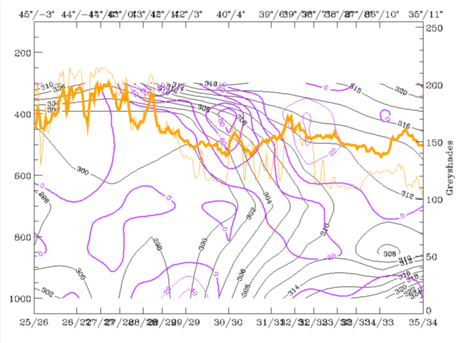
12 November 1997/06.00 UTC - Vertical cross section; black: isentropes (ThetaE), lilac: Q-Vector (normal component), orange thin: IR pixel values, orange
thick: WV pixel values
|
|
|
|
The most pronounced upward motion is in upper levels where there is some higher cloud close to the leading edge of the frontal cloud band. Increasing values of positive vorticity advection (PVA) (left image) are directly within the frontal crowding zone, while in the higher part above 650 hPa high values of the frontogenetic parameter (right image) indicate further frontogenesis. So summarizing, there is a well-developed Cold Front zone down to about 800 - 750 hPa indicating further strengthening but with a superadiabatic boundary layer below.
12 November 1997/06.00 UTC - Meteosat IR image; yellow: positive vorticity advection (PVA) 500 hPa
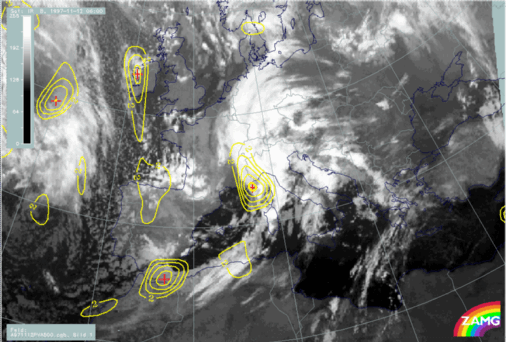
As PVA could be identified in the vertical cross section the image above shows the distribution of this parameter at 500 hPa. The most notable centres are connected with the Wave and close to the EC over Spain, respectively; both areas will be discussed separately in the following chapters (compare
Wave development in the area Sardinia - Corsica and
Intensification of frontal cloudiness and activity by jet streak crossing.
12 November 1997/06.00 UTC - Meteosat IR image; blue: thermal front parameter (TFP) 500/850 hPa, red: temperature advection 1000 hPa
The Warm Front (WF band) is of a cloud band type with a well-developed WA maximum in front of the TFP (right image). Notable is the intersection of CA over the Alpine area.
|
12 November 1997/06.00 UTC - Meteosat IR image; position of vertical cross section indicated
|
12 November 1997/06.00 UTC - Vertical cross section; black: isentropes (ThetaE), red thin: temperature advection - CA, red thick: temperature
advection - WA, orange thin: IR pixel values, orange thick: WV pixel values
|
|
|
|
A vertical cross section across this area shows that there is extremely intensive CA in the middle and low layer of the troposphere but WA above. The question about the origin of this CA arises, of course.
|
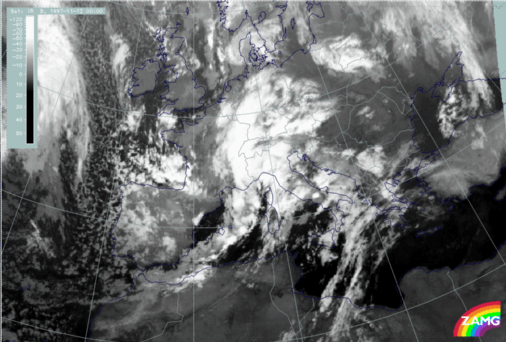
12 November 1997/00.00 UTC - Meteosat IR image
|
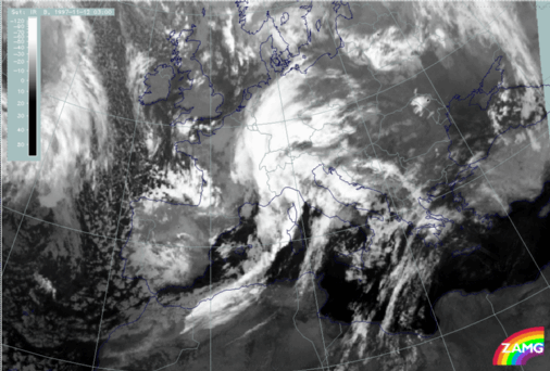
12 November 1997/03.00 UTC - Meteosat IR image
|
|
|
|
Images of 00.00 (left image) and 03.00 UTC (right image) of the same day show that approximately six hours earlier a Wave development took place over France; the appearance in the images is very similar to a cold conveyor belt development with a low cloud spiral emerging from below. CA could be the remains of this Wave development while at 06.00 UTC the southern Wave development dominates.