24 - 30 SEPTEMBER 1997 - INTRODUCTION AND CONCEPTUAL MODELS
by KNMI
Introduction
Thanks are due to Mr. Riosalido from Instituto Nacional de Meteorologica (I.N.M.) in Madrid in selecting the case and adding important information and advice.
This case study handles the life cycle of an Upper Level Low in chronological order. The system developed over the Atlantic Ocean west of the Iberian Peninsula and reached its mature stage near the entrance of the Strait of Gibraltar on the 28th of September.
From the 26th till the 30th of September 1997 this system was responsible for heavy rainfall especially in the southern part of Spain and the northern part of Marocco. At the east side of the ULL frontogenesis in an unstable environment caused upward motion and the development of cloud bands with embedded Cb's, Cb Clusters and MCSs. The severe weather conditions were at their maximum in the dissolution stage of the Upper Level Low. In the southern and south eastern parts of the peninsula flooding affected many areas and caused a lot of damage to agriculture. In Spain there were five casualties due to the flooding and two as a result of a plane crash in severe weather conditions.
Overview of satellite features and conceptual models
|
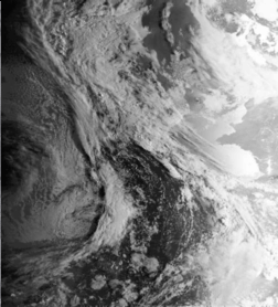
24 September 1997/08.00 UTC - NOAA CH2 image
|
24 September 1997/08.00 UTC - NOAA CH5 image
|
|
|
- A Cold Front ("CF I") extending from NE Spain to W. Ireland in an irregular cloud band (compare Conceptual Models: Cold Front ).
- The cloud system over the eastern part of the Atlantic can also be identified as a Cold Front ("CF II") (compare Conceptual Models: Cold Front ) and is starting to tear-off an extended baroclinic zone stretching out north towards Greenland.
CF II is approaching the Iberian Peninsula while CF I is in a decaying stage.
To the rear of CF I a trough at upper levels has formed. To the rear of CF II a (small) trough is also developing.
The Trough Stage
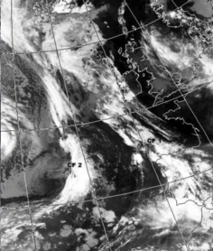
- CF I is located over the Iberian Peninsula, and is situated ahead of the upper level trough.
- CF II is rapidly moving eastwards and is extending over the Atlantic Ocean at 20W and lies upstream of the 500 hPa trough axis of the main system. (compare Conceptual Models: Upper Level Low - Meteorological physical background ).
The Tear-off Stage
- CF I is partly dissolved and has merged with CF II.
- The remainders of the CF (II) is extending from N. Marocco to N. Portugal.
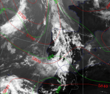
- The height contours are showing a closed circulation with minima of 576 gpdam. The fronts have lost their association with the cloud bands that extended in northern direction towards Greenland and Ireland. This indicates the tear-off stage of an Upper Level Low (Compare Conceptual Models: Upper Level Low - Meteorological physical background ).
- There is cold advection over the Atlantic Ocean (the western part of Portugal). This can be seen in the isohypses at 500 hPa, which are perpendicular to the lines of equivalent thickness. This indicates that the ULL is still moving and developing.
The Cut-off Stage
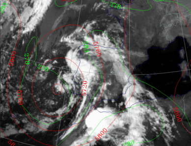
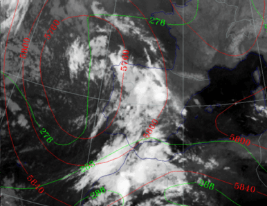
- The centre of the ULL has moved in a southward direction, with minimum height contour values of 568 gpdam, indicating a further deepening of the ULL.
- The ULL is in its cut-off stage because cloud and height tear-off has stopped and the ULL is now more pronounced.
- Cold advection can be found below the centre of the ULL, near the west coast of Morocco.
- The remnants of the CF band starts to curve cyclonically around the centre of the ULL.
- An intense white spot can be seen at the west side of a thickness ridge above Morocco, indicating an MCS.
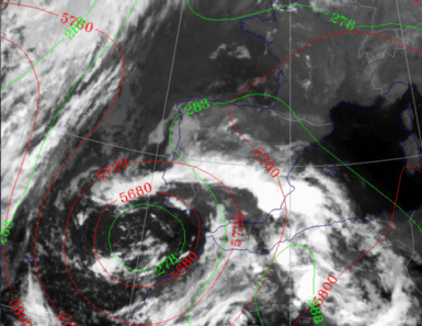
- The centre of ULL is now at its lowest value and is located SW of Portugal.
- The height contours at 500 hPa show a well-developed closed circulation (compare Conceptual Models: Upper Level Low - Meteorological physical background ).
- Values of Cold Advection are near zero, because the centre of the thermal low has the same location as the minimum in the height contours.
- The cyclonic curvature of the cloud bands becomes stronger, which indicates the maturity of the cut-off stage of the ULL.
The Dissolution Stage
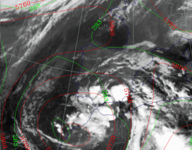
- The ULL has propagated in a SE direction. The values of the isohypses in the centre show that the ULL is in its early dissolution stage.
- CB clusters develop over S Spain and N Morocco at the edge of the ULL, indicating a potentially unstable stratification of the troposphere. (Compare Conceptual Models: Cumulonimbus (Cb) and Mesoscale Convective System (MCS) and Conceptual Models: Cumulonimbus Cluster ).
- At this stage the most severe weather was observed. In particular, high amounts of rainfall were observed over Andalucia and the
Alicante province.
In Alicante the maximum of the intensity of the rainfall was 60mm/hr. In a period of 5 hours 267 mm was measured.
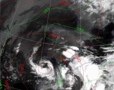
- The ULL is dissolving further, which can be seen in the height contours at 500 hPa, which are showing higher values in the centre of the ULL.
- Warmer, moist air has spiralled into the centre of the low as can be seen in the cloud imagery.
- Embedded CB Clusters can be seen in the area of the thickness ridge above SE Spain and west Algeria, indicating an unstable airmass.

