Upper Level Low - Meteorological Physical Background
by ZAMG and FMI
The development of a typical Upper Level Low goes through four stages, during which a bottom of an upper trough is detached from the main stream, until it finally fills up or merges with another trough:
- Upper level trough
- Tear-off
- Cut-off
- Final stage
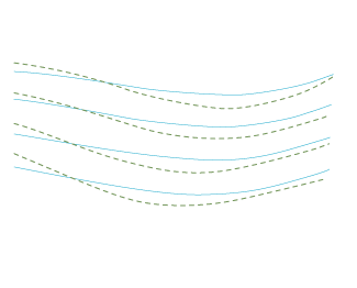
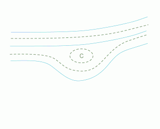
1. Upper Level Trough stage
The prerequisite of the forming of the Upper Level Low are unstable waves within the main stream, where the temperature wave is behind the geopotential wave.- There is cold advection within the trough and warm advection on the ridge of the geopotential wave.
- The vertical axis of the trough has a backward-oriented inclination with height.
- The amplitudes of the waves increase; the wavelenght can decrease.
|
Cyan: 500 hPa geopotential height, green: 500 hPa temperature
|
|
|
|
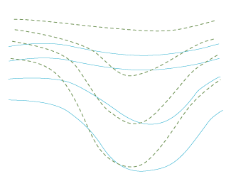
2. Tear-off stage
- The amplitudes of the waves increases further.
- The isohypses form an inverse omega-shape and the cold air flows into the middle of this omega.
- Often at the same time the ridge behind the main upper trough continues to move eastward quicklier than the trough, appearing to "fall forward".
- In the end of this stage the cold bottom of the trough is detached from the main stream.
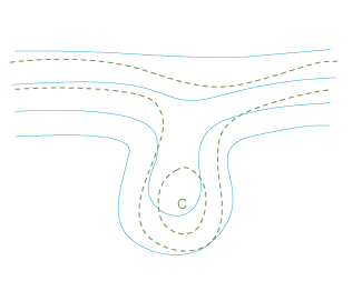
3. Cut-off stage
- The bottom of the upper trough is completely detached from the main stream forming a closed circulation.
- If there is a strong forward-falling ridge behind, it may also separate from the main stream and form an upper level high (a counterpart for the upper level low). This happens in most of the ULL cases.
- The cold core of the Upper level Low warms up slowly because of the diabatic warming of the sinking clod air.
- If a cold Upper Level Low is situated over a warm surface, convection arises within the core. This occurs especially over the Atlantic Ocean (Canarian Isles) and over the Mediterranean in summertime.
- Another location for convection is ahead of the low within the area of a thickness ridge.
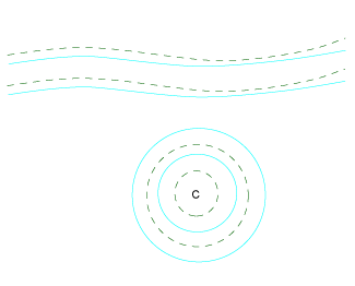
4. Final stage
Within an Upper Level Low there is convection, unless the surface is very cold. The air near the surface is warm and the circulation is slowed down by the friction. The convection brings warm air and friction upwards. Consequently, the Upper Level Low weakens slowly.- In most cases the Upper Level Low merges with the main stream before it has completely dissolved by the convection. Usually a large trough in the main stream approaches from the rear and catches the upper level low.
- The Upper Level Low can also merge with another Upper Level Low.
If the Upper Level Low is far from the main stream, it can dissolve solely by convection. This kind of development occurs mostly in southern areas; in Europe they can be found over the Mediterranean.
Upper Level Lows can be divided into two classes according to their size and lifetime:
- small lows with a lifetime of 2-4 days
- big lows with a lifetime of 5-14 days
Note that over land an Upper Level Low can also form when a surface low of an extratropical cyclone disappears due to friction. This is just a late stage of a cyclone development and the upper low fills up relatively quickly.


