29 JULY 1997 - SATELLITE FEATURES AND FRONTAL DIAGNOSIS FOR 18.00 UTC
by ZAMG
29 July 1997/18.00 UTC - Meteosat IR image; red: height contours 1000 hPa, yellow: height contours 300 hPa
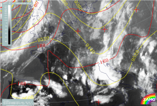
The image above shows the situation for 18 UTC. At this point of time only one main cloud system can be observed extending from south-east Austria across
Slovenia and the Adriatic Sea to Italy, consisting of huge thunderstorm complexes. The development of the MCSs will be shown in a separate chapter. The cloud band with much lower tops and only small convective cells at the eastern boundary over Croatia, Hungary and Slovakia can be evaluated as the remnants of the convergence band.
The surface level still shows an area of very weak gradients but in the upper levels there is a pronounced trough which has approached during the last 12 hours from Germany and has been superimposed on the convergence band originally situated there. This is one reason for the development of the strong thunderstorms.
29 July 1997/18.00 UTC - Meteosat IR image; blue: thermal front parameter (TFP) 500/850 hPa, green: equivalent thickness 500/850 hPa, red:
temparature advection - WA 1000 hPa
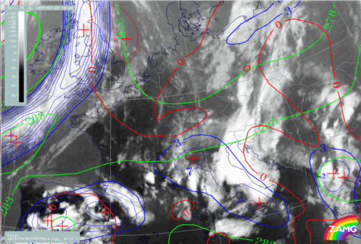
As can be seen from the image above, there is no notable change in the frontal characteristics; the area under consideration is still an east-west oriented air mass boundary. The new TFP branch over Italy is a consequence of the intensive cloudiness there. As before, well-developed frontal characteristics can be observed only at the cloud band over the Atlantic and England; however the relation to temperature advection has changed there and the biggest part of this cloud band is now under CA.


