29 JULY 1997 - SATELLITE FEATURES AND FRONTAL DIAGNOSIS FOR 12.00 UTC
by ZAMG
29 July 1997/12.00 UTC - Meteosat IR image; red: height contours 1000 hPa, green: height contours 500 hPa
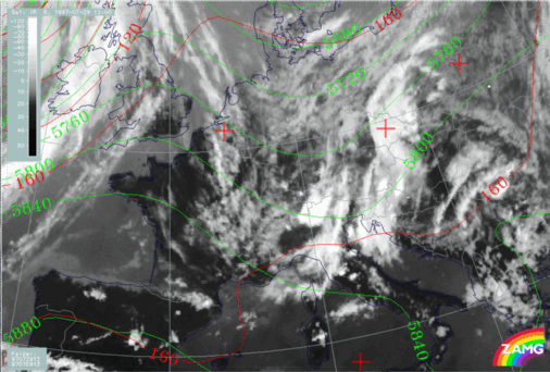
The expected mergence of the two cloud systems can already be observed at 12.00 UTC. The image above shows the eastern cloud system nearly at the same location as at 06.00 UTC extending from the north Adriatic Sea across east Austria to Poland (compare
Frontal Diagnosis
). The western system can now be located over west Austria and north Italy much closer to the eastern system. A thick convective cell has already developed over the Alps (centred around 46N/10E). Smaller cloud cells can be observed in the whole area especially over middle Italy.
As before there is a big area of high pressure at the surface (red lines) without any distinct gradients but a pronounced upper level trough (height contours at 300 hPa - yellow) connected with the western system.
29 July 1997/12.00 UTC - Meteosat IR image; blue: thermal front parameter (TFP) 500/850 hPa, green: equivalent thickness 500/850 hPa, red:
temparature advection - WA 1000 hPa
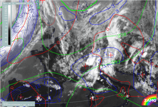
Also same as before are the frontal characteristics (image above); there is no frontal character in the area under consideration but only an air mass boundary (compare
Frontal Diagnosis
). An active front can be diagnosed for the cloud band at the western boundary of the image over the British Isles.


