07 JUNE 1997 - DIAGNOSIS FOR 07 JUNE 12.00 UTC
by KNMI
|
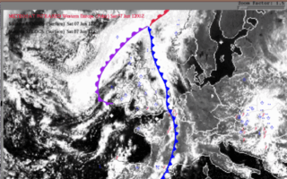
07 June 1997/12.00 UTC - Meteosat VIS image; weather events (blue: WW code, red: SFLOCS)
|
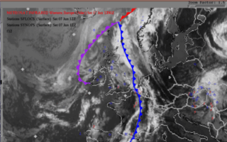
07 June 1997/12.00 UTC - Meteosat IR image; weather events (blue: WW code, red: SFLOCS)
|
|
|
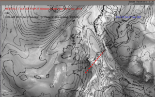
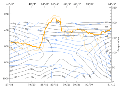
ABSTOP1000 + WA1000-500 + CA 500-300 + IR + Vertical Cross Section
|
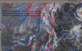
07 June 1997/12.00 UTC - Meteosat IR image; cyan: height contours 1000 hPa, red: temperature advection - WA 1000 hPa, blue:temperature advection -
CA 500hPa; position of vertical cross section indicated
|
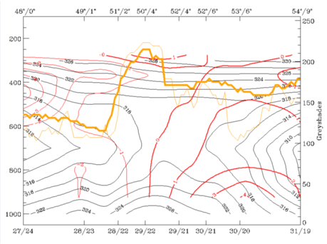
07 June 1997/12.00 UTC - Vertical cross section; black: isentropes (ThetaE), red thin: temperature advection - CA, red thick: temperature
advection - WA, orange thin: IR pixel values, orange thick: WV pixel values
|
|
|
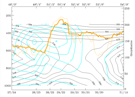
ThetaW 850 hPa + WV + Vertical Cross Section with relative humidity
|
07 June 1997/12.00 UTC - Meteosat WV image; black: wet bulb temperature 850 hPa; position of vertical cross section indicated
|
07 June 1997/12.00 UTC - Vertical cross section; black: isentropes (ThetaE), blue: relative humidity, orange thin: IR pixel values, orange thick:
WV pixel values
|
|
|
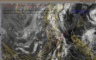
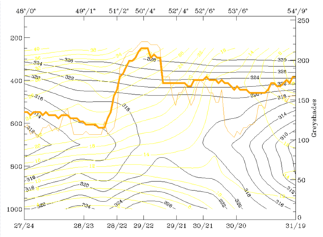
Isotachs 250 hPa >= 60kt + PVA500 >= 2 + IR + Vertical Cross Section
|
07 June 1997/12.00 UTC - Meteosat IR image; black: positive vorticity advection (PVA) 500 hPa, yellow: isotachs 250 hPa; position of vertical
cross section indicated
|
07 June 1997/12.00 UTC - Vertical cross section; black: isentropes (ThetaE), yellow: isotachs, orange thin: IR pixel values, orange thick:
WV pixel values
|
|
|
|
|
|
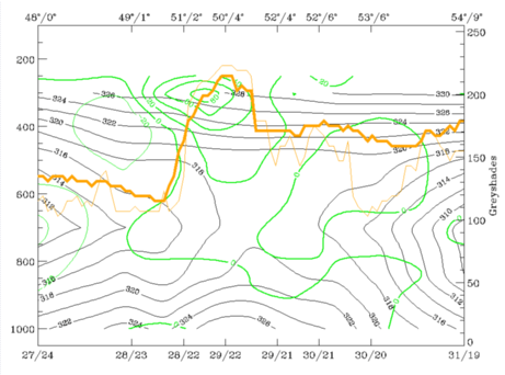
07 June 1997/12.00 UTC - Vertical cross section; black: isentropes (ThetaE), green thick: vorticity advection - PVA, green thin: vorticity
advection - NVA, orange thin: IR pixel values, orange thick: WV pixel values
|
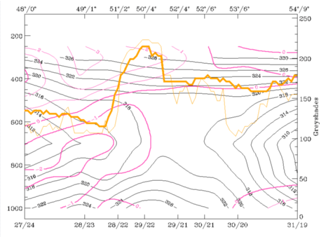
Divergence and vertical motion
|
07 June 1997/12.00 UTC - Vertical cross section; black: isentropes (ThetaE), magenta thin: divergence, magenta thick: convergence, orange thin: IR
pixel values, orange thick: WV pixel values
|
07 June 1997/12.00 UTC - Vertical cross section; black: isentropes (ThetaE), cyan thick: vertical motion (omega) - upward motion, cyan thin:
vertical motion (omega) - downward motion, orange thin: IR pixel values, orange thick: WV pixel values
|
|
|
Summary of diagnosis 12.00 UTC
The convective cluster over the southern Netherlands is now clearly under the influence of dynamic forcing. The temperature advection distribution, with warm advection in the lower layers and cold advection above, unstabilises the atmosphere. Strong convection is possible in such a situation.Strong positive vorticity advection causes strong upward motion which intensifies the activity of the MCS.


