07 JUNE 1997 - DEVELOPMENT OF THE MCS BETWEEN 06.00 UTC AND 12.00 UTC
by KNMI
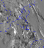
Developments and movements of the most important cloud clusters shows best with deviation images. High pixel values (white) indicate movement or/and development of high clouds, while low pixel values (black) give an indication of decreasing cloudiness.
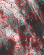
These deviation values can also be calculated. Positive values signify developing cloudiness, negative values dissolving cloudiness.
|
07 June 1997/08.00 - 09.00 UTC - Meteosat IR development image
|
07 June 1997/09.00 UTC - Meteosat IR image; red: mean values of grey shades of cloud development and decay
|
|
|
|
In the development image the white area just north of Paris indicates very strong developments in the cloud cluster which has moved steadily north-east in the period from 06.00 till 09.00 UTC. South-west of the area a black spot can be seen which indicates dissolving of the clouds. From the development values it can be seen that the maximum development of the cluster is at the north-eastern edge, while the maximum decay (negative values) is at the south-westerly side.
Radiosonde Soundings
Soundings from radiosondes are very helpful in detecting an unstable air mass. They have the advantage of giving a true picture of the state of the atmosphere, more than model fields can do. A disadvantage is the fact that they represent only a one dimensional state of the atmosphere. To make use of these soundings one has to assume that the data are representative of the whole air mass.
07 June 1997/12.00 UTC - Radiosounding De Bilt (06260)
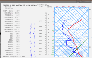
The radiosonde was released at 11.00 UTC in the same air mass as that in which the investigated cloud cluster existed. Particularly striking are the high instability values from the different instability indices which are listed at the left side of the tephigram. For instance the Boyden index (boyd) and the Total totals index (TTI) show very high values indicating the possibilities of heavy and frequent thunderstorm activity. The air is very unstable below 200 hPa with the exception of two capping inversions at 900 and 630 hPa. These inversions were situated below potential unstable layers and could therefore easily disappear in the case of strong convection. A strong positive vertical windshear is shown with a general veering with height.