07 JUNE 1997 - MATURE STAGE OF THE SYSTEM
by KNMI
|
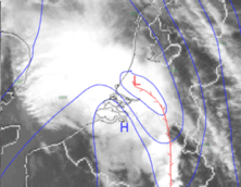
07 June 1997/13.00 UTC - NOAA HRPT image; blue: surface isobars, red: convergence line
|
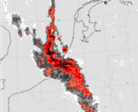
07 June 1997/13.00 UTC - Radar image; red: precipitation rates
|
|
|
The original Cold Front has amalgamated with the thermal trough which was originally situated in front of it. Significant is the sharp ridge in the isobars at the rear of the squall line due to the outflow of cold air from the storm cells. In the north-western part of the system the outflow patterns are to be seen over the North Sea. They may be the result of a strong rising Warm Conveyor Belt over the original Cold Front. Relative streams can give more clarity about this feature.
After 13.00 UTC the activity of the system decreased although thunderstorms were still reported in the remnants of the cluster at 18.00 UTC.


