19 FEBRUARY 1997 - USE OF VERTICAL CROSS SECTIONS FOR 00.00 UTC
by ZAMG
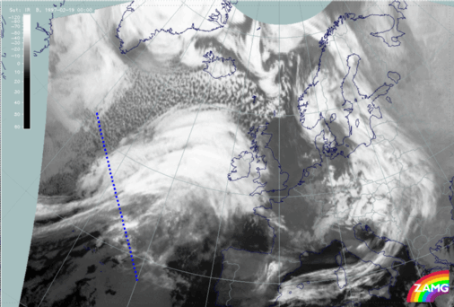
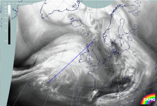
19 February 1997/00.00 UTC - Meteosat IR image; position of vertical cross section indicated
|
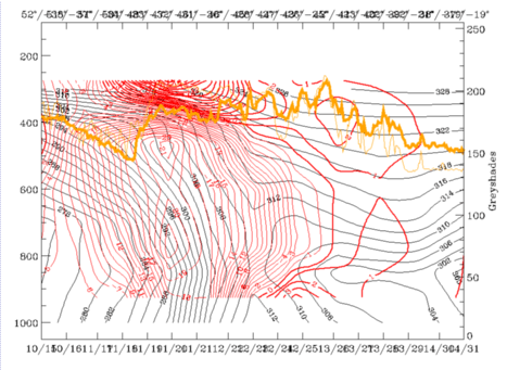
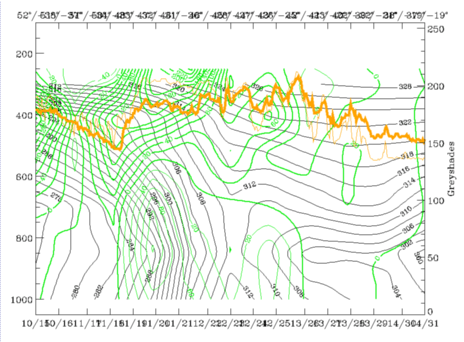
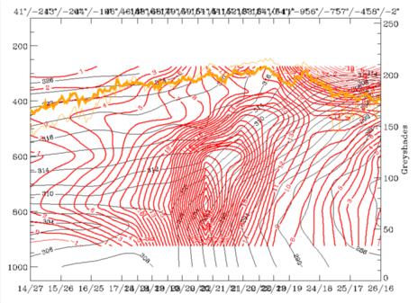
19 February 1997/00.00 UTC - Vertical cross section; black: isentropes (ThetaE), red thin: temperature advection - CA, red thick: temperature
advection - WA, orange thin: IR pixel values, orange thick: WV pixel values
|
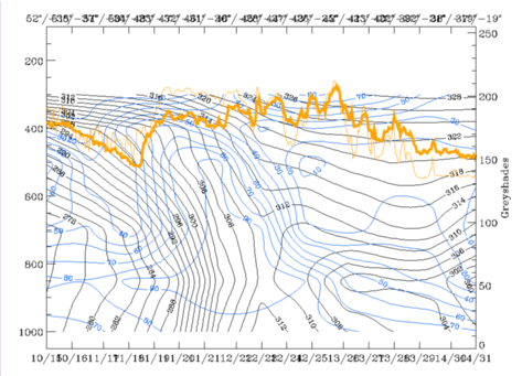
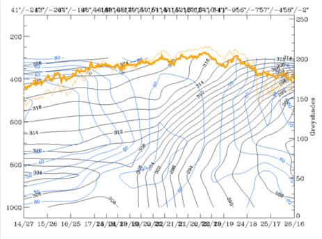
19 February 1997/00.00 UTC - Vertical cross section; black: isentropes (ThetaE), blue: relative humidity, orange thin: IR pixel values, orange
thick: WV pixel values
|
|
|
|
|
|
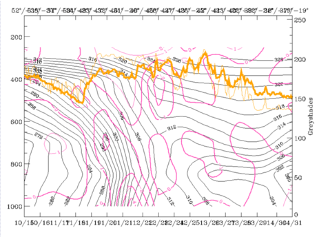
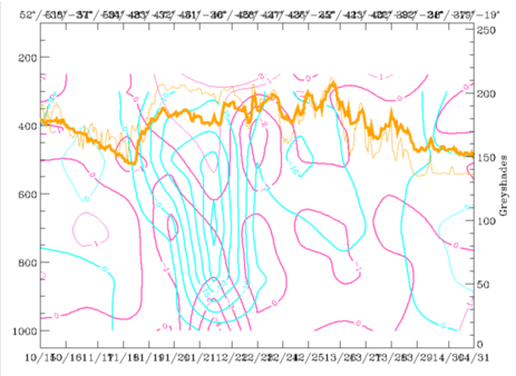
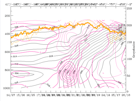
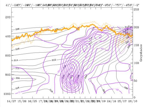
19 February 1997/00.00 UTC - Vertical cross section; black: isentropes (ThetaE), magenta thin: divergence, magenta thick: convergence, orange thin:
IR pixel values, orange thick: WV pixel values
|
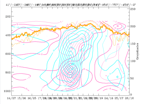
19 February 1997/00.00 UTC - Vertical cross section; cyan thick: vertical motion (omega) - upward motion, cyan thin: vertical motion (omega) -
downward motion, magenta thin: divergence, magenta thick: convergence, orange thin: IR pixel values, orange thick: WV pixel values
pixel values
|
|
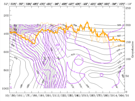
19 February 1997/00.00 UTC - Vertical cross section; black: isentropes (ThetaE), green thick: vorticity advection - PVA, green thin: vorticity
advection - NVA, orange thin: IR pixel values, orange thick: WV pixel values
|
19 February 1997/00.00 UTC - Vertical cross section; black: isentropes (ThetaE), lilac: Q-Vector (normal component), orange thin: IR pixel values,
orange thick: WV pixel values
|
|
|
19 February 1997/00.00 UTC - Meteosat WV image; position of vertical cross section indicated
|
19 February 1997/00.00 UTC - Vertical cross section; black: isentropes (ThetaE), red thin: temperature advection - CA, red thick: temperature
advection - WA, orange thin: IR pixel values, orange thick: WV pixel values
|
19 February 1997/00.00 UTC - Vertical cross section; black: isentropes (ThetaE), blue: relative humidity, orange thin: IR pixel values, orange
thick: WV pixel values
|
|
|
|
|
|
19 February 1997/00.00 UTC - Vertical cross section; black: isentropes (ThetaE), magenta thin: divergence, magenta thick: convergence, orange thin:
IR pixel values, orange thick: WV pixel values
|
19 February 1997/00.00 UTC - Vertical cross section; cyan thick: vertical motion (omega) - upward motion, cyan thin: vertical motion (omega) -
downward motion, magenta thin: divergence, magenta thick: convergence, orange thin: IR pixel values, orange thick: WV pixel values
|
19 February 1997/00.00 UTC - Vertical cross section; black: isentropes (ThetaE), lilac: Q-Vector (normal component), orange thin: IR pixel values, orange
thick: WV pixel values
Summarizing these diagnoses one can say that both Cold Front and Warm Front represent well-developed conceptual models (compare Conceptual Models: Cold Front and Conceptual Models: Warm Front Shield ) with rather classical distributions of the relevant key parameters. The next sub-chapter deals with the frontal situation six hours later (compare Frontal Diagnosis - 19 February 1997/06.00 UTC).


